TopoQuest Logo
Do you find TopoQuest useful?
Help keep TopoQuest running and adding new maps/features by donating!
Bitcoin:  19c7KJd3qBynnjoSw5npx9KScwjBe4ifkT
Litecoin:  LXs6TkuXGGXo1vDsWCkWVdjQX94eUKd6ui
Home View Maps Find Maps Find Places Resources & Links


Enterprise, Oklahoma Topographic Map

USGS Map Title: Enterprise, OK
USGS Map MRC: 35095B4
DRG (GeoTIFF) Download: o35095b4.tif


Neighboring USGS Topographic Map Quads:


  Eufaula, OK  
35095C5
 

  Texanna, OK  
35095C4
 

  Porum, OK  
35095C3
 

  Longtown, OK  
35095B5
 

  Enterprise, OK  
35095B4
 

  Quinton North, OK  
35095B3
 

  Blocker, OK  
35095A5
 

  Featherston, OK  
35095A4
 

  Quinton South, OK  
35095A3


Map MRC Location:

N36°
W96°
N36°
W95°
H8 H7 H6 H5 H4 H3 H2 H1
G8 G7 G6 G5 G4 G3 G2 G1
F8 F7 F6 F5 F4 F3 F2 F1
E8 E7 E6 E5 E4 E3 E2 E1
D8 D7 D6 D5 D4 D3 D2 D1
C8 C7 C6 C5 C4 C3 C2 C1
B8 B7 B6 B5 B4 B3 B2 B1
A8 A7 A6 A5 A4 A3 A2 A1
N35°
W96°
N35°
W95°

Enterprise, OK USGS 1:24K Topographic Map Preview:
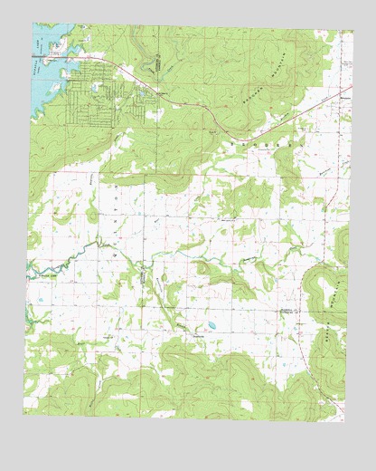
Enterprise, OK USGS Topographic Map
Click on map above to begin viewing in our Map Viewer.

This topographic map contains these locations and features:
Feature Name Type Latitude Longitude GNIS ID View Map
Bear CreekStreamN35.1782°W95.4639°1089901View Map
Brooken MountainSummitN35.2320°W95.4028°1090520View Map
EnterprisePopulated PlaceN35.2298°W95.3800°1092629View Map
Enterprise CemeteryCemeteryN35.2115°W95.4061°1092630View Map
Enterprise CemeteryCemeteryN35.2184°W95.3919°1092631View Map
Enterprise Census Designated PlaceCensusN35.2210°W95.3925°2629917View Map
Haytubbi CreekStreamN35.1798°W95.4725°1093622View Map
Heifer CreekStreamN35.1479°W95.4778°1093651View Map
Highway 9 LandingPopulated PlaceN35.2401°W95.4925°1100496View Map
House CreekStreamN35.1548°W95.4986°1093972View Map
Oak Ridge ChurchChurchN35.2284°W95.4508°1096126View Map
Oknoname 121003 DamDamN35.2284°W95.4769°1755539View Map
Oknoname 121003 ReservoirReservoirN35.2294°W95.4757°1755540View Map
Oknoname 121015 DamDamN35.2268°W95.4569°1755563View Map
Oknoname 121015 ReservoirReservoirN35.2284°W95.4568°1755564View Map
Palestine CemeteryCemeteryN35.1508°W95.4653°2712532View Map
Palestine ChurchChurchN35.1507°W95.4661°1096388View Map
RussellvillePopulated PlaceN35.1518°W95.4353°1100804View Map
Russellville BranchStreamN35.1729°W95.4528°1097546View Map
Township of BrookenCivilN35.2126°W95.3975°1824653View Map
West Liberty CemeteryCemeteryN35.1889°W95.4189°2709109View Map
West Liberty ChurchChurchN35.1887°W95.4194°1099580View Map

Note: Coordinates in the location and feature list above are referenced to NAD83 datum.


Copyright (C) 2008-2025 Ryan Niemi / Sunset Dynamics ... All Rights Reserved