TopoQuest Logo
Do you find TopoQuest useful?
Help keep TopoQuest running and adding new maps/features by donating!
Bitcoin:  19c7KJd3qBynnjoSw5npx9KScwjBe4ifkT
Litecoin:  LXs6TkuXGGXo1vDsWCkWVdjQX94eUKd6ui
Home View Maps Find Maps Find Places Resources & Links


Quinton North, Oklahoma Topographic Map

USGS Map Title: Quinton North, OK
USGS Map MRC: 35095B3
DRG (GeoTIFF) Download: o35095b3.tif


Neighboring USGS Topographic Map Quads:


  Texanna, OK  
35095C4
 

  Porum, OK  
35095C3
 

  Stigler West, OK  
35095C2
 

  Enterprise, OK  
35095B4
 

  Quinton North, OK  
35095B3
 

  Sans Bois, OK  
35095B2
 

  Featherston, OK  
35095A4
 

  Quinton South, OK  
35095A3
 

  Kinta, OK  
35095A2


Map MRC Location:

N36°
W96°
N36°
W95°
H8 H7 H6 H5 H4 H3 H2 H1
G8 G7 G6 G5 G4 G3 G2 G1
F8 F7 F6 F5 F4 F3 F2 F1
E8 E7 E6 E5 E4 E3 E2 E1
D8 D7 D6 D5 D4 D3 D2 D1
C8 C7 C6 C5 C4 C3 C2 C1
B8 B7 B6 B5 B4 B3 B2 B1
A8 A7 A6 A5 A4 A3 A2 A1
N35°
W96°
N35°
W95°

Quinton North, OK USGS 1:24K Topographic Map Preview:
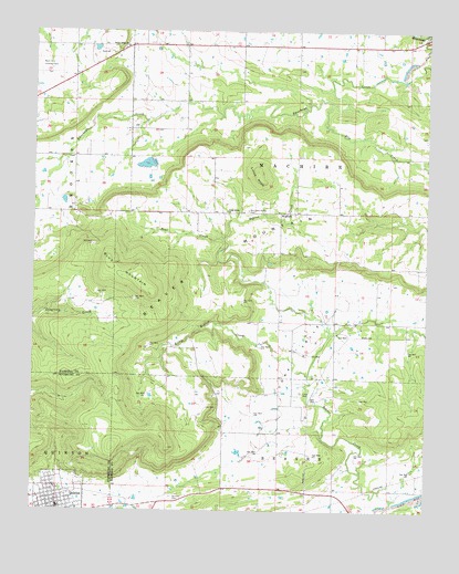
Quinton North, OK USGS Topographic Map
Click on map above to begin viewing in our Map Viewer.

This topographic map contains these locations and features:
Feature Name Type Latitude Longitude GNIS ID View Map
Bear CreekStreamN35.1957°W95.3150°1089902View Map
Beaver MountainSummitN35.1818°W95.3375°1089945View Map
Blu MountainSummitN35.1819°W95.3376°1090263View Map
Elm CreekStreamN35.2143°W95.2502°1092565View Map
HughartPopulated PlaceN35.2026°W95.2964°1100513View Map
Jesus Name ChurchChurchN35.2032°W95.3133°1094221View Map
KOET-TV (Eufaula)TowerN35.1837°W95.3391°1102832View Map
Little Beaver CreekStreamN35.1604°W95.2877°1094710View Map
Little KnobSummitN35.2134°W95.3036°1094787View Map
Lona CemeteryCemeteryN35.1559°W95.2897°1094890View Map
Lona ValleyValleyN35.1443°W95.2828°1094891View Map
Lona Valley Volunteer Fire DepartmentBuildingN35.1734°W95.2968°2657484View Map
Mountain Home CemeteryCemeteryN35.2034°W95.3064°1095647View Map
OETA Channel 3TowerN35.1815°W95.3369°1763630View Map
Quinton CemeteryCemeteryN35.1287°W95.3311°1096997View Map
Quinton Elementary SchoolSchoolN35.1309°W95.3676°1790776View Map
Quinton High SchoolSchoolN35.1262°W95.3662°1819303View Map
Sandy Ridge ChurchChurchN35.2459°W95.3458°1097828View Map
Township of MachireCivilN35.2154°W95.2919°1824654View Map
West Haskell DivisionCivilN35.1823°W95.2965°1937916View Map

Note: Coordinates in the location and feature list above are referenced to NAD83 datum.


Copyright (C) 2008-2025 Ryan Niemi / Sunset Dynamics ... All Rights Reserved