TopoQuest Logo
Do you find TopoQuest useful?
Help keep TopoQuest running and adding new maps/features by donating!
Bitcoin:  19c7KJd3qBynnjoSw5npx9KScwjBe4ifkT
Litecoin:  LXs6TkuXGGXo1vDsWCkWVdjQX94eUKd6ui
Home View Maps Find Maps Find Places Resources & Links


Epping, New Hampshire Topographic Map

USGS Map Title: Epping, NH
USGS Map MRC: 43071A1
DRG (GeoTIFF) Download: o43071a1.tif


Neighboring USGS Topographic Map Quads:


  Northwood, NH  
43071B2
 

  Barrington, NH  
43071B1
 

  Dover West, NH  
43070B8
 

  Mount Pawtuckaway, NH  
43071A2
 

  Epping, NH  
43071A1
 

  Newmarket, NH  
43070A8
 

  Sandown, NH  
42071H2
 

  Kingston, NH  
42071H1


Map MRC Location:

N44°
W72°
N44°
W71°
H8 H7 H6 H5 H4 H3 H2 H1
G8 G7 G6 G5 G4 G3 G2 G1
F8 F7 F6 F5 F4 F3 F2 F1
E8 E7 E6 E5 E4 E3 E2 E1
D8 D7 D6 D5 D4 D3 D2 D1
C8 C7 C6 C5 C4 C3 C2 C1
B8 B7 B6 B5 B4 B3 B2 B1
A8 A7 A6 A5 A4 A3 A2 A1
N43°
W72°
N43°
W71°

Epping, NH USGS 1:24K Topographic Map Preview:
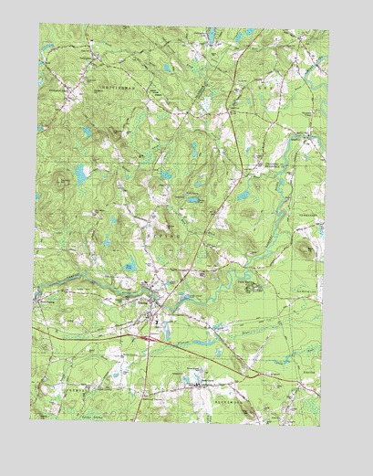
Epping, NH USGS Topographic Map
Click on map above to begin viewing in our Map Viewer.

This topographic map contains these locations and features:
Feature Name Type Latitude Longitude GNIS ID View Map
Bald HillSummitN43.0554°W71.0076°865346View Map
Brentwood CornersPopulated PlaceN43.0084°W71.0762°865780View Map
Brown BrookStreamN43.0165°W71.0837°2062879View Map
Camp HeddingPopulated PlaceN43.0429°W71.0317°865931View Map
Dame SchoolSchoolN43.1201°W71.1017°1914197View Map
Deer HillSummitN43.0051°W71.0306°866527View Map
EppingPopulated PlaceN43.0334°W71.0742°866805View Map
Epping Census Designated PlaceCensusN43.0345°W71.0903°2378062View Map
Epping Elementary SchoolSchoolN43.0455°W71.0754°1914231View Map
Epping Fire Department Central StationBuildingN43.0397°W71.0765°2605079View Map
Epping High SchoolSchoolN43.0442°W71.0756°2499430View Map
Epping Middle SchoolSchoolN43.0441°W71.0792°1914232View Map
Epping Police DeptBuildingN43.0394°W71.0729°2752814View Map
Epping Post OfficePost OfficeN43.0345°W71.0730°1914233View Map
Exeter High SchoolSchoolN43.0166°W71.0009°2499448View Map
Fox Run CampgroundLocaleN43.0906°W71.0123°1914762View Map
Glenmere VillagePopulated PlaceN43.0995°W71.0059°867084View Map
Harvey-Mitchell Memorial LibraryBuildingN43.0356°W71.0739°1914309View Map
Hoar PondReservoirN43.0492°W71.0827°1914317View Map
Hogarth Country Day SchoolSchoolN43.0375°W71.0712°2499415View Map
Isinglass HillSummitN43.1018°W71.1040°867727View Map
Jones HillSummitN43.0409°W71.1056°867805View Map
Kennard HillSummitN43.0756°W71.1153°867841View Map
Ladd CemeteryCemeteryN43.0646°W71.0749°867919View Map
Lawrence Yard CemeteryCemeteryN43.0773°W71.0492°1914351View Map
LeePopulated PlaceN43.1231°W71.0114°867983View Map
Lee Congregational ChurchChurchN43.1243°W71.0095°1914816View Map
Lee Fire and Rescue DepartmentBuildingN43.1241°W71.0155°2605050View Map
Lee Hill CemeteryCemeteryN43.1227°W71.0101°1914815View Map
Lee Police DepartmentBuildingN43.1239°W71.0157°2752807View Map
Lee Public LibraryBuildingN43.1237°W71.0098°1914818View Map
Little RiverStreamN43.1120°W71.0095°868086View Map
Lyford CrossingPopulated PlaceN43.0112°W71.0989°868215View Map
Magney HillSummitN43.0909°W71.0917°1914374View Map
Maple Tree PreschoolSchoolN43.0393°W71.0730°2499392View Map
Marston Pond DamDamN43.1201°W71.0495°1775689View Map
Martin CrossingPopulated PlaceN43.0209°W71.0859°871204View Map
Mitchel Memorial HospitalHospitalN43.0123°W71.0526°868501View Map
Moses Davis CemeteryCemeteryN43.0820°W71.0289°866494View Map
Muddy PondLakeN43.0743°W71.0648°1914388View Map
New England Dragway IncorporatedBuildingN43.0208°W71.0270°2605238View Map
New Hampshire State Police Troop ABuildingN43.0465°W71.0578°2753022View Map
North EppingPopulated PlaceN43.0715°W71.0603°871209View Map
North RiverStreamN43.0790°W71.0203°868808View Map
NottinghamPopulated PlaceN43.1145°W71.0998°868845View Map
Nottingham Community ChurchChurchN43.1137°W71.1006°1914442View Map
Nottingham LakeReservoirN43.1250°W71.0504°1775690View Map
Nottingham Police DeptBuildingN43.1197°W71.1020°2752828View Map
Nottingham Post OfficePost OfficeN43.1117°W71.0951°1914443View Map
Nottingham SquarePopulated PlaceN43.1031°W71.1106°868847View Map
Plumer CemeteryCemeteryN43.0499°W71.0573°1914462View Map
Prospect CemeteryCemeteryN43.0379°W71.0841°1914468View Map
Quaker CemeteryCemeteryN43.0417°W71.1231°1914469View Map
Redoak HillSummitN43.0618°W71.0695°869473View Map
Rockingham County FarmLocaleN43.0120°W71.0531°1914478View Map
Rockingham County Sheriff's OfficeBuildingN43.0143°W71.0507°2752855View Map
Rockingham Regional AmbulanceBuildingN43.0107°W71.0739°2658875View Map
Rollins BrookStreamN43.0926°W71.0567°1914482View Map
Rundlett HillSummitN43.0654°W71.0984°869644View Map
Saint Joseph Parish ChurchChurchN43.0345°W71.0748°1914498View Map
Seacoast Learning Collaborative SchoolSchoolN43.0166°W71.0237°2499491View Map
Sleeper CemeteryCemeteryN43.0156°W71.0850°1914539View Map
Smith State ForestForestN43.1048°W71.0745°869988View Map
South LeePopulated PlaceN43.0987°W71.0417°870042View Map
South Side CemeteryCemeteryN43.1067°W71.1042°1914563View Map
Square SchoolhouseSchoolN43.1034°W71.1101°1914568View Map
Star SpeedwayParkN43.0293°W71.0409°1914570View Map
Three Ponds CampgroundLocaleN43.0720°W71.0689°1914601View Map
Town of EppingCivilN43.0501°W71.0747°873591View Map
Town of LeeCivilN43.1197°W71.0069°873644View Map
Town of NottinghamCivilN43.1242°W71.1210°873690View Map
Wadley FallsPopulated PlaceN43.0920°W71.0078°870631View Map
Watson AcademySchoolN43.0431°W71.0753°870682View Map
West EppingPopulated PlaceN43.0373°W71.1226°871296View Map
Wiggin CemeteryCemeteryN43.0795°W71.0138°870885View Map

Note: Coordinates in the location and feature list above are referenced to NAD83 datum.


Copyright (C) 2008-2024 Ryan Niemi / Sunset Dynamics ... All Rights Reserved