TopoQuest Logo
Do you find TopoQuest useful?
Help keep TopoQuest running and adding new maps/features by donating!
Bitcoin:  19c7KJd3qBynnjoSw5npx9KScwjBe4ifkT
Litecoin:  LXs6TkuXGGXo1vDsWCkWVdjQX94eUKd6ui
Home View Maps Find Maps Find Places Resources & Links


Barrington, New Hampshire Topographic Map

USGS Map Title: Barrington, NH
USGS Map MRC: 43071B1
DRG (GeoTIFF) Download: o43071b1.tif


Neighboring USGS Topographic Map Quads:


  Parker Mountain, NH  
43071C2
 

  Baxter Lake, NH  
43071C1
 

  Rochester, NH  
43070C8
 

  Northwood, NH  
43071B2
 

  Barrington, NH  
43071B1
 

  Dover West, NH  
43070B8
 

  Mount Pawtuckaway, NH  
43071A2
 

  Epping, NH  
43071A1
 

  Newmarket, NH  
43070A8


Map MRC Location:

N44°
W72°
N44°
W71°
H8 H7 H6 H5 H4 H3 H2 H1
G8 G7 G6 G5 G4 G3 G2 G1
F8 F7 F6 F5 F4 F3 F2 F1
E8 E7 E6 E5 E4 E3 E2 E1
D8 D7 D6 D5 D4 D3 D2 D1
C8 C7 C6 C5 C4 C3 C2 C1
B8 B7 B6 B5 B4 B3 B2 B1
A8 A7 A6 A5 A4 A3 A2 A1
N43°
W72°
N43°
W71°

Barrington, NH USGS 1:24K Topographic Map Preview:
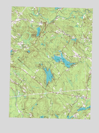
Barrington, NH USGS Topographic Map
Click on map above to begin viewing in our Map Viewer.

This topographic map contains these locations and features:
Feature Name Type Latitude Longitude GNIS ID View Map
Ayers Lake CampgroundLocaleN43.2490°W71.0495°1914684View Map
Ayers Lake DamDamN43.2484°W71.0581°1775048View Map
BarringtonPopulated PlaceN43.2229°W71.0470°865393View Map
Barrington Ambulance ServiceBuildingN43.2152°W71.0118°2658845View Map
Barrington Evangelical ChurchChurchN43.2279°W71.0526°1914686View Map
Barrington Fire and RescueBuildingN43.2152°W71.0116°2605075View Map
Barrington Police DeptBuildingN43.2152°W71.0113°2752974View Map
Bean RiverStreamN43.1306°W71.1106°865433View Map
Beauty HillSummitN43.1970°W71.0226°865467View Map
Berrys HillSummitN43.2401°W71.0065°865560View Map
Bumfagging HillSummitN43.1931°W71.1051°865853View Map
Caldwell BrookStreamN43.1515°W71.0228°865902View Map
Calef IslandIslandN43.1867°W71.0342°1914697View Map
Camp Don BoscoLocaleN43.2290°W71.0837°1914698View Map
Camp SpeedwellLocaleN43.1923°W71.0373°865954View Map
Canaan ChapelChurchN43.2045°W71.1023°1914699View Map
Capon CemeteryCemeteryN43.2201°W71.0392°1914700View Map
Cate PondLakeN43.2297°W71.0227°1914702View Map
Cedar WatersPopulated PlaceN43.1265°W71.0703°1914177View Map
Cedar WatersLakeN43.1264°W71.0737°866067View Map
Chapel of the NativityChurchN43.2154°W71.0065°1914706View Map
Childrens Workshop Nursery SchoolSchoolN43.1515°W71.0303°2499406View Map
Clark CemeteryCemeteryN43.2167°W71.0817°1914715View Map
Cocheco Arts and Technology Charter AcademySchoolN43.2195°W71.0375°2499490View Map
Cooper HillSummitN43.1876°W71.1215°866329View Map
Creek PondLakeN43.1681°W71.0326°1914723View Map
Cyrus PondLakeN43.1404°W71.0833°866453View Map
Davis PondLakeN43.1929°W71.1178°866501View Map
East BarringtonPopulated PlaceN43.2156°W71.0067°866686View Map
Evans CemeteryCemeteryN43.1826°W71.0817°1914747View Map
First Congregational ChurchChurchN43.2159°W71.0076°1914753View Map
Forest Glen CampgroundLocaleN43.1370°W71.0014°1914760View Map
Fort HillSummitN43.1293°W71.0598°866929View Map
Good Shepherd SchoolSchoolN43.2186°W71.0345°2499428View Map
Hale PondLakeN43.2222°W71.0726°867306View Map
Hall BrookStreamN43.2115°W71.1020°867322View Map
Hanson CemeteryCemeteryN43.2422°W71.1121°1914785View Map
Huckleberry HillSummitN43.2234°W71.0356°867665View Map
Langley PondLakeN43.1359°W71.0888°867948View Map
Len Kay Camping AreaLocaleN43.1845°W71.0292°1914821View Map
Locke CemeteryCemeteryN43.1947°W71.0092°868113View Map
Mast Way SchoolSchoolN43.1256°W71.0079°2499432View Map
Mendums PondReservoirN43.1733°W71.0652°868383View Map
Mendums Pond DamDamN43.1643°W71.0684°1774993View Map
Merri - Lee Child Care CenterSchoolN43.1593°W71.0039°2499455View Map
Merry HillSummitN43.1709°W71.0867°868403View Map
Mica PointCapeN43.1909°W71.0448°1914842View Map
Mile BrookStreamN43.1270°W71.1178°871276View Map
Mount MiserySummitN43.2212°W71.0773°868599View Map
Nippo BrookStreamN43.2440°W71.0934°868746View Map
Nippo HillSummitN43.2179°W71.0906°868747View Map
Nippo Lake Golf ClubLocaleN43.2312°W71.0809°1914857View Map
Nippo Lake Ski Touring CenterLocaleN43.2304°W71.0840°1914858View Map
Nippo PondReservoirN43.2227°W71.0825°868748View Map
Nippo Pond DamDamN43.2256°W71.0859°1774967View Map
North NottinghamPopulated PlaceN43.1670°W71.1056°868799View Map
Nottingham Elementary SchoolSchoolN43.1465°W71.1111°2499440View Map
Nottingham Fire DepartmentBuildingN43.1434°W71.1118°2605096View Map
Nottingham State ForestForestN43.1348°W71.1053°868848View Map
Peaked HillSummitN43.1879°W71.0426°869037View Map
Peavy HillSummitN43.1251°W71.0898°869048View Map
Pine Grove CemeteryCemeteryN43.2135°W71.0040°869165View Map
Round PondLakeN43.1856°W71.0760°869608View Map
Round PondsLakeN43.2073°W71.0725°869619View Map
Scruton PondReservoirN43.2403°W71.0275°866050View Map
Shackford-Jenness CemeteryCemeteryN43.2331°W71.1235°1914909View Map
South BarringtonPopulated PlaceN43.1823°W71.0342°871232View Map
Spruce BrookStreamN43.2209°W71.1053°870109View Map
Stonehouse BrookStreamN43.2290°W71.0937°870198View Map
Stonehouse PondReservoirN43.1998°W71.0964°870200View Map
Sunnyside HillSummitN43.2242°W71.0615°870281View Map
Sunnyside SchoolSchoolN43.2209°W71.0515°870282View Map
Swains LakeReservoirN43.1904°W71.0437°870298View Map
Town of BarringtonCivilN43.2140°W71.0424°873538View Map
Union LakeReservoirN43.1904°W71.0437°1775173View Map
Union Lake DamDamN43.1884°W71.0245°1775172View Map
University of New Hampshire Lee Center WestSchoolN43.1509°W71.0128°1914949View Map
University of New Hampshire School of Continuing StudiesSchoolN43.1506°W71.0120°1914950View Map
West BarringtonPopulated PlaceN43.2048°W71.1045°870742View Map
Wheelwright PondLakeN43.1372°W71.0090°870825View Map

Note: Coordinates in the location and feature list above are referenced to NAD83 datum.


Copyright (C) 2008-2025 Ryan Niemi / Sunset Dynamics ... All Rights Reserved