TopoQuest Logo
Do you find TopoQuest useful?
Help keep TopoQuest running and adding new maps/features by donating!
Bitcoin:  19c7KJd3qBynnjoSw5npx9KScwjBe4ifkT
Litecoin:  LXs6TkuXGGXo1vDsWCkWVdjQX94eUKd6ui
Home View Maps Find Maps Find Places Resources & Links


Erie, Colorado Topographic Map

USGS Map Title: Erie, CO
USGS Map MRC: 40105A1
DRG (GeoTIFF) Download: o40105a1.tif


Neighboring USGS Topographic Map Quads:


  Hygiene, CO  
40105B2
 

  Longmont, CO  
40105B1
 

  Gowanda, CO  
40104B8
 

  Niwot, CO  
40105A2
 

  Erie, CO  
40105A1
 

  Frederick, CO  
40104A8
 

  Louisville, CO  
39105H2
 

  Lafayette, CO  
39105H1
 

  Eastlake, CO  
39104H8


Map MRC Location:

N41°
W106°
N41°
W105°
H8 H7 H6 H5 H4 H3 H2 H1
G8 G7 G6 G5 G4 G3 G2 G1
F8 F7 F6 F5 F4 F3 F2 F1
E8 E7 E6 E5 E4 E3 E2 E1
D8 D7 D6 D5 D4 D3 D2 D1
C8 C7 C6 C5 C4 C3 C2 C1
B8 B7 B6 B5 B4 B3 B2 B1
A8 A7 A6 A5 A4 A3 A2 A1
N40°
W106°
N40°
W105°

Erie, CO USGS 1:24K Topographic Map Preview:
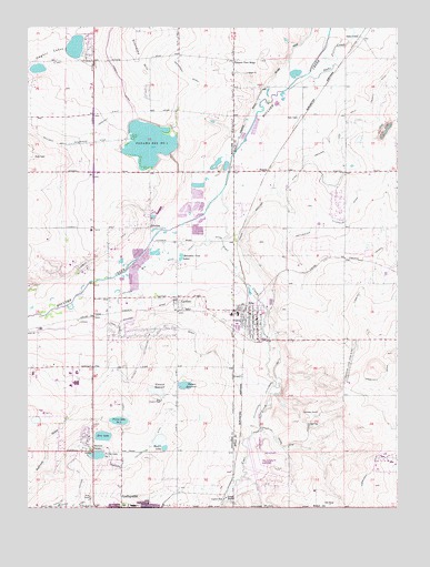
Erie, CO USGS Topographic Map
Click on map above to begin viewing in our Map Viewer.

This topographic map contains these locations and features:
Feature Name Type Latitude Longitude GNIS ID View Map
Alexander Dawson SchoolSchoolN40.0633°W105.1105°2060190View Map
Aspen Ridge Preparatory SchoolSchoolN40.0334°W105.0539°2730272View Map
Bailey Gravel PitMineN40.0508°W105.0508°1683936View Map
Black Rock Elementary SchoolSchoolN40.0062°W105.0158°2730276View Map
Boulder and Weld County DitchCanalN40.0833°W105.0416°202595View Map
Boulder Valley MineMineN40.0639°W105.0547°1683938View Map
Boulder Valley MineMineN40.0389°W105.0197°1683968View Map
Boulder Valley MineMineN40.0494°W105.0425°1683969View Map
Brennan MineMineN40.0500°W105.0644°1683939View Map
Briggs MineMineN40.0439°W105.0533°1683970View Map
Bullhead GulchValleyN40.0283°W105.1084°181229View Map
C and M Gravel PitMineN40.0508°W105.0508°1683940View Map
CanfieldPopulated PlaceN40.0536°W105.0747°178599View Map
Carr and Tyler DitchCanalN40.1163°W105.0186°2711485View Map
Chase MineMineN40.0472°W105.0672°1683942View Map
Clayton MineMineN40.0519°W105.0108°1683971View Map
Cleveland MineMineN40.0347°W105.0658°1683943View Map
Coal CreekStreamN40.0822°W105.0594°181118View Map
Colorado National Golf ClubLocaleN40.0050°W105.0252°2723808View Map
Columbine MineMineN40.0253°W105.0272°178734View Map
Cottonwood Extension DitchCanalN40.0528°W105.0425°178733View Map
Crandell Number One MineMineN40.0025°W105.0228°1685251View Map
Dave's AirportAirportN40.0349°W105.1241°204499View Map
Denver Regional LandfillLocaleN40.0247°W105.0275°2677961View Map
Elmwood DamDamN40.0300°W105.0797°198584View Map
Elmwood ReservoirReservoirN40.0304°W105.0814°178746View Map
EriePopulated PlaceN40.0503°W105.0500°178731View Map
Erie DamDamN40.0200°W105.0989°198586View Map
Erie Elementary SchoolSchoolN40.0503°W105.0565°2060185View Map
Erie Filtration PlantBuildingN40.0283°W105.0803°178745View Map
Erie High SchoolSchoolN40.0480°W105.0161°2060188View Map
Erie LakeReservoirN40.0188°W105.0994°178740View Map
Erie Middle SchoolSchoolN40.0508°W105.0537°2060187View Map
Erie MineMineN40.0986°W105.0047°178735View Map
Erie MineMineN40.0494°W105.0425°1735427View Map
Erie Municipal AirportAirportN40.0092°W105.0494°204388View Map
Erie PitMineN40.0508°W105.0508°1683945View Map
Erie Police DepartmentBuildingN40.0443°W105.0565°2732380View Map
Erie Post OfficePost OfficeN40.0499°W105.0471°2732375View Map
Escuela Bilingüe Pioneer SchoolSchoolN40.0007°W105.0893°2442432View Map
Eureka Number One MineMineN40.1036°W105.0003°1683994View Map
Excelsior MineMineN40.0069°W105.0839°1683946View Map
Fox Hole AirportAirportN40.0057°W105.0716°2443931View Map
Garfield MineMineN40.0333°W105.0672°1683947View Map
Garfield Number Two MineMineN40.0392°W105.0530°1683972View Map
Gaynor DamDamN40.1167°W105.1172°198704View Map
Gaynor LakeLakeN40.1167°W105.1172°178729View Map
Gladstone MineMineN40.0055°W105.0922°1683948View Map
Godding Dailey and Plumb DitchCanalN40.1222°W105.0311°202566View Map
GoodingPopulated PlaceN40.0736°W105.0830°178727View Map
Hayward MineMineN40.0022°W105.0586°178742View Map
Idaho CreekPopulated PlaceN40.1222°W105.0130°178736View Map
Jackson MineMineN40.0833°W105.0616°1735426View Map
Lafayette Fire DepartmentBuildingN40.0016°W105.0939°2060192View Map
Lafayette Police DepartmentBuildingN40.0025°W105.0946°2036543View Map
Lafayette Public LibraryBuildingN40.0008°W105.1003°2036536View Map
Lehigh MineMineN40.0333°W105.0478°1683950View Map
LeynerPopulated PlaceN40.0497°W105.1025°178725View Map
Leyner Census Designated PlaceCensusN40.0511°W105.1074°2583260View Map
Leyner Cottonwood Number 1 DitchCanalN40.0389°W105.0866°169491View Map
Leyners Hayfield Airport (historical)AirportN40.0461°W105.1125°204475View Map
Liggett DitchCanalN40.0861°W105.0811°202569View Map
Lister MineMineN40.0333°W105.0672°1683951View Map
Lloyd MineMineN40.0367°W105.0530°1683974View Map
Longs Peak MineMineN40.0833°W105.0616°1683952View Map
Lower Boulder DitchCanalN40.0569°W105.0672°202593View Map
MacGregor MineMineN40.0333°W105.0672°1683953View Map
Marfell Lake Number 1ReservoirN40.0183°W105.0805°198617View Map
Marfell Lake Number 1 DamDamN40.0183°W105.0805°198616View Map
Marfell LakesReservoirN40.0179°W105.0805°178744View Map
Marfell MineMineN40.0333°W105.0672°1683954View Map
Mile Hi MineMineN40.0222°W105.1005°1683955View Map
Mitchell MineMineN40.0055°W105.0922°1683956View Map
Mitchell Number Two MineMineN40.0305°W105.0569°1683975View Map
Monroe MineMineN40.0044°W105.0358°1683976View Map
Mountain View Fire Protection District Station 5 BrownsvilleBuildingN40.0501°W105.0976°2368603View Map
Mountain View Fire Protection District Station 6 ErieBuildingN40.0432°W105.0376°2060189View Map
Mountain View LakesReservoirN40.0653°W105.0736°178726View Map
New Star MineMineN40.0833°W105.0616°1683957View Map
Ninemile CornerPopulated PlaceN40.0153°W105.1036°178737View Map
North Colorado Med EvacBuildingN40.0109°W105.0543°2716949View Map
Northrup MineMineN40.0833°W105.0616°1683958View Map
Northwestern MineMineN40.0500°W105.0728°1683959View Map
Northwestern MineMineN40.0464°W105.0386°1683977View Map
Pallotts Coal WorkingsMineN40.0392°W105.0530°1683978View Map
Panama Number 1 DamDamN40.0930°W105.0758°198628View Map
Panama Reservoir Number 1ReservoirN40.0949°W105.0842°178728View Map
Paramount MineMineN40.0025°W105.1239°1683960View Map
Park MineMineN40.0083°W105.0450°1683961View Map
Parkland AirportAirportN40.0711°W105.0262°204389View Map
Pinnacle MineMineN40.0333°W105.0672°1683931View Map
Pleasant View RidgePopulated PlaceN40.1167°W105.0555°178732View Map
PlumbsPopulated PlaceN40.0878°W105.0439°178741View Map
Prince Lake Number OneReservoirN40.0140°W105.1010°178739View Map
Prince Lake Number TwoReservoirN40.0229°W105.0942°178738View Map
Prince Number 1 DamDamN40.0133°W105.1005°198630View Map
Prince Number 2 DamDamN40.0233°W105.0922°198632View Map
Red Hawk Elementary SchoolSchoolN40.0436°W105.0661°2730309View Map
Reliance MineMineN40.0642°W105.0291°1683979View Map
Simpson Coal MineMineN40.0055°W105.0922°1683963View Map
South Boulder CanyonCanalN40.0139°W105.0978°178743View Map
Standley HillSummitN40.1239°W105.0883°202594View Map
Star MineMineN40.0555°W105.0703°1683964View Map
State PitMineN40.0386°W105.0197°1683980View Map
Stewart MineMineN40.0500°W105.0603°1685243View Map
Stuart MineMineN40.0333°W105.0672°1683932View Map
TaborPopulated PlaceN40.0514°W105.0741°178748View Map
Thomas ReservoirReservoirN40.0320°W105.0719°178747View Map
Town of ErieCivilN40.0404°W105.0395°2412599View Map
Tri-County HeliportAirportN40.0105°W105.0525°204387View Map
Tynan MineMineN40.0333°W105.0672°1683933View Map
Vista Ridge AcademySchoolN40.0017°W105.0119°2060191View Map
Vista Ridge AcademySchoolN40.0036°W105.0108°2036534View Map
Warwick MineMineN40.0333°W105.0672°1683934View Map
Washington MineMineN40.0333°W105.0672°1683935View Map
Whiterock DitchCanalN40.1167°W105.0755°178730View Map

Note: Coordinates in the location and feature list above are referenced to NAD83 datum.


Copyright (C) 2008-2024 Ryan Niemi / Sunset Dynamics ... All Rights Reserved