TopoQuest Logo
Do you find TopoQuest useful?
Help keep TopoQuest running and adding new maps/features by donating!
Bitcoin:  19c7KJd3qBynnjoSw5npx9KScwjBe4ifkT
Litecoin:  LXs6TkuXGGXo1vDsWCkWVdjQX94eUKd6ui
Home View Maps Find Maps Find Places Resources & Links


Hygiene, Colorado Topographic Map

USGS Map Title: Hygiene, CO
USGS Map MRC: 40105B2
DRG (GeoTIFF) Download: o40105b2.tif


Neighboring USGS Topographic Map Quads:


  Pinewood Lake, CO  
40105C3
 

  Carter Lake Reservoir, CO  
40105C2
 

  Berthoud, CO  
40105C1
 

  Lyons, CO  
40105B3
 

  Hygiene, CO  
40105B2
 

  Longmont, CO  
40105B1
 

  Boulder, CO  
40105A3
 

  Niwot, CO  
40105A2
 

  Erie, CO  
40105A1


Map MRC Location:

N41°
W106°
N41°
W105°
H8 H7 H6 H5 H4 H3 H2 H1
G8 G7 G6 G5 G4 G3 G2 G1
F8 F7 F6 F5 F4 F3 F2 F1
E8 E7 E6 E5 E4 E3 E2 E1
D8 D7 D6 D5 D4 D3 D2 D1
C8 C7 C6 C5 C4 C3 C2 C1
B8 B7 B6 B5 B4 B3 B2 B1
A8 A7 A6 A5 A4 A3 A2 A1
N40°
W106°
N40°
W105°

Hygiene, CO USGS 1:24K Topographic Map Preview:
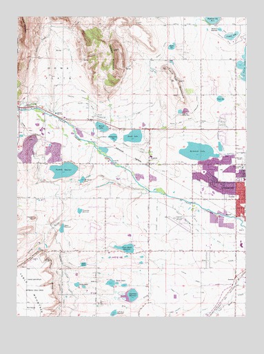
Hygiene, CO USGS Topographic Map
Click on map above to begin viewing in our Map Viewer.

This topographic map contains these locations and features:
Feature Name Type Latitude Longitude GNIS ID View Map
Bellmire ReservoirReservoirN40.2448°W105.1397°178344View Map
Bohn LakeReservoirN40.1468°W105.2138°178320View Map
Boulder Feeder CanalCanalN40.1417°W105.2222°202564View Map
Burch LakeReservoirN40.2002°W105.1865°178334View Map
Centennial Square Shopping CenterLocaleN40.1861°W105.1311°1763974View Map
Clark DamDamN40.2147°W105.1394°201054View Map
Clark ReservoirReservoirN40.2159°W105.1394°178339View Map
Clover Basin DamDamN40.1522°W105.1864°198496View Map
Clover Basin DitchCanalN40.1500°W105.1689°178350View Map
Clover Basin ReservoirReservoirN40.1536°W105.1904°178321View Map
Crystal DamDamN40.2417°W105.1305°199738View Map
Crystal LakeReservoirN40.2422°W105.1333°178337View Map
Davis and Downing DitchCanalN40.1761°W105.1817°2711859View Map
Davis DamDamN40.1620°W105.2248°200350View Map
Davis ReservoirReservoirN40.1616°W105.2256°178322View Map
Denver ARTCC HeliportAirportN40.1869°W105.1269°204496View Map
DominionPopulated PlaceN40.1430°W105.1269°178314View Map
Dowe FlatsFlatN40.2264°W105.2283°178342View Map
Flagstaff AcademySchoolN40.1407°W105.1274°2730186View Map
Foothills DamDamN40.1893°W105.2221°198498View Map
Foothills Inlet DitchCanalN40.1981°W105.2332°2712097View Map
Foothills ReservoirReservoirN40.1860°W105.2245°178329View Map
Front Range Community College Boulder County CampusSchoolN40.1384°W105.1301°2057426View Map
Frontier PitMineN40.1878°W105.1780°1683636View Map
Goss Private Ditch Number 1CanalN40.1984°W105.2227°2712310View Map
Highland DitchCanalN40.2139°W105.2089°202519View Map
Highland Number 2 DamDamN40.2472°W105.1436°200360View Map
HygienePopulated PlaceN40.1886°W105.1808°178333View Map
Hygiene Fire DepartmentBuildingN40.1891°W105.1778°2368660View Map
Hygiene North CemeteryCemeteryN40.1894°W105.1689°2062318View Map
Hygiene PitMineN40.1886°W105.1944°1683641View Map
Hygiene Post OfficePost OfficeN40.1894°W105.1776°2750932View Map
Hygiene South CemeteryCemeteryN40.1883°W105.1689°2062319View Map
Independent DamDamN40.1983°W105.1969°200386View Map
Independent ReservoirReservoirN40.1999°W105.1976°178335View Map
James DitchCanalN40.1653°W105.1925°178349View Map
KLMO-AM (Longmont)TowerN40.1911°W105.1269°204038View Map
Knoth DamDamN40.2389°W105.1641°198502View Map
Knoth ReservoirReservoirN40.2377°W105.1658°178340View Map
KQKS-FM (Longmont)TowerN40.1911°W105.1269°204163View Map
Lagerman DamDamN40.1342°W105.1844°200390View Map
Lagerman ReservoirReservoirN40.1338°W105.1879°178316View Map
Left Hand DamDamN40.1264°W105.1969°201694View Map
Left Hand ReservoirReservoirN40.1265°W105.1972°178315View Map
Longmont Church of the NazareneChurchN40.1805°W105.1286°2036533View Map
Longmont DivisionCivilN40.1781°W105.1814°1935515View Map
Longmont Filtration PlantLocaleN40.2128°W105.2461°178346View Map
Longmont Fire Department Station 2BuildingN40.1813°W105.1319°2368599View Map
Longmont Fire Department Station 5BuildingN40.1516°W105.1527°2368602View Map
Longmont Supply DitchCanalN40.1944°W105.1822°178347View Map
Longmont United HospitalHospitalN40.1822°W105.1262°2036529View Map
Longmont United Hospital HeliportAirportN40.1786°W105.1258°204497View Map
Longmont Water TankReservoirN40.2128°W105.2292°178345View Map
Longs Peak Filtration PlantLocaleN40.2097°W105.1614°178338View Map
Longs Peak Number 1 DamDamN40.2100°W105.1605°198508View Map
Longs Peak Number 2 DamDamN40.2100°W105.1572°198510View Map
Longs Peak Reservoir Number 1ReservoirN40.2106°W105.1613°198509View Map
Longs Peak Reservoir Number 2ReservoirN40.2109°W105.1584°198511View Map
Lykins GulchValleyN40.1650°W105.2249°178284View Map
Marlatt PitMineN40.1878°W105.1780°1683637View Map
MarnettPopulated PlaceN40.1683°W105.1339°178325View Map
Marnette PitMineN40.1636°W105.1328°1683638View Map
Martin Marietta Limestone QuarryMineN40.2000°W105.2172°1683635View Map
McCall DamDamN40.2033°W105.2022°200854View Map
McCall LakeReservoirN40.2041°W105.2040°178336View Map
McCaslin DamDamN40.1831°W105.2136°200394View Map
McCaslin LakeReservoirN40.1820°W105.2146°178330View Map
McIntosh DamDamN40.1914°W105.1572°200396View Map
McIntosh LakeReservoirN40.1939°W105.1514°178332View Map
Mill DitchCanalN40.1833°W105.1617°178331View Map
Montview Shopping CenterLocaleN40.1828°W105.1297°1763977View Map
Mullen ParkFlatN40.2353°W105.1272°178279View Map
Niwot DitchCanalN40.1583°W105.1464°178326View Map
Northwest Mutual DitchCanalN40.1725°W105.1661°2723803View Map
Oligarchy Number 1 DamDamN40.1967°W105.1889°200408View Map
Oligarchy Reservoir Number 1ReservoirN40.1967°W105.1889°200409View Map
Palmerton DitchCanalN40.2083°W105.1894°202555View Map
Peck DitchCanalN40.1639°W105.1842°178351View Map
Potato HillSummitN40.1658°W105.2408°178328View Map
Rabbit MountainSummitN40.2361°W105.1978°178343View Map
Rough and Ready DitchCanalN40.2111°W105.1422°202557View Map
Ryssby ChurchChurchN40.1397°W105.2064°178318View Map
Ryssby Church CemeteryCemeteryN40.1397°W105.2055°2062317View Map
Silver CreekStreamN40.1425°W105.1764°1930510View Map
Silver Creek High SchoolSchoolN40.1512°W105.1672°1927054View Map
Slinde DamDamN40.1467°W105.2122°198522View Map
Smead DitchCanalN40.2100°W105.2488°2724265View Map
South Flat DitchCanalN40.1611°W105.1478°178327View Map
Spirit of Peace Catholicf ChurchChurchN40.1853°W105.1305°2036532View Map
Steele Brothers Number 1 DamDamN40.1391°W105.2163°200366View Map
Steele Brothers Number 2 DamDamN40.1377°W105.2128°200368View Map
Steele Brothers Reservoir Number 1ReservoirN40.1383°W105.2173°200367View Map
Steele Brothers Reservoir Number 2ReservoirN40.1375°W105.2136°200369View Map
Steele LakesReservoirN40.1380°W105.2155°178319View Map
STK Longmont HeliportAirportN40.1386°W105.1369°204498View Map
Swede DamDamN40.1389°W105.1950°200788View Map
Swede DitchCanalN40.1667°W105.2228°202556View Map
Swede LakesReservoirN40.1389°W105.1954°178317View Map
Table Mountain Antenna Field SitesAreaN40.1333°W105.2450°178288View Map
Table Top MountainSummitN40.2283°W105.1686°178341View Map
Terry LateralCanalN40.2444°W105.1308°202562View Map
Trevarton ReservoirReservoirN40.1691°W105.2159°178323View Map
Twin Peaks MallLocaleN40.1417°W105.1305°1763980View Map
Vance Brand AirportAirportN40.1655°W105.1624°178324View Map
Weisner CemeteryCemeteryN40.2062°W105.2469°2062315View Map
Weng PitMineN40.2025°W105.2086°1683639View Map
Westview Presbyterian ChurchChurchN40.1855°W105.1305°2036530View Map
Ziegler PitMineN40.2028°W105.2086°1683640View Map

Note: Coordinates in the location and feature list above are referenced to NAD83 datum.


Copyright (C) 2008-2024 Ryan Niemi / Sunset Dynamics ... All Rights Reserved