TopoQuest Logo
Do you find TopoQuest useful?
Help keep TopoQuest running and adding new maps/features by donating!
Bitcoin:  19c7KJd3qBynnjoSw5npx9KScwjBe4ifkT
Litecoin:  LXs6TkuXGGXo1vDsWCkWVdjQX94eUKd6ui
Home View Maps Find Maps Find Places Resources & Links


Errol, New Hampshire Topographic Map

USGS Map Title: Errol, NH
USGS Map MRC: 44071G2
DRG (GeoTIFF) Download: o44071g2.tif


Neighboring USGS Topographic Map Quads:


  Diamond Pond, NH  
44071H3
 

  Mount Pisgah, NH  
44071H2
 

  Wilsons Mills, ME  
44071H1
 

  Dixville Notch, NH  
44071G3
 

  Errol, NH  
44071G2
 

  Umbagog Lake North, NH  
44071G1
 

  Dummer Ponds, NH  
44071F3
 

  Teakettle Ridge, NH  
44071F2
 

  Umbagog Lake South, NH  
44071F1


Map MRC Location:

N45°
W72°
N45°
W71°
H8 H7 H6 H5 H4 H3 H2 H1
G8 G7 G6 G5 G4 G3 G2 G1
F8 F7 F6 F5 F4 F3 F2 F1
E8 E7 E6 E5 E4 E3 E2 E1
D8 D7 D6 D5 D4 D3 D2 D1
C8 C7 C6 C5 C4 C3 C2 C1
B8 B7 B6 B5 B4 B3 B2 B1
A8 A7 A6 A5 A4 A3 A2 A1
N44°
W72°
N44°
W71°

Errol, NH USGS 1:24K Topographic Map Preview:
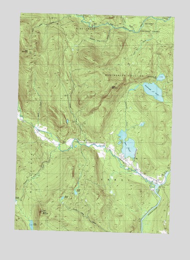
Errol, NH USGS Topographic Map
Click on map above to begin viewing in our Map Viewer.

This topographic map contains these locations and features:
Feature Name Type Latitude Longitude GNIS ID View Map
Akers PondReservoirN44.8003°W71.1600°865208View Map
Akers Pond DamDamN44.7917°W71.1495°1775822View Map
Black MountainSummitN44.8348°W71.1762°865629View Map
Clear StreamStreamN44.7784°W71.1381°866205View Map
Corser BrookStreamN44.7995°W71.1926°866354View Map
Dixie DamDamN44.8678°W71.1923°866590View Map
East Branch Swift Diamond RiverStreamN44.8659°W71.1567°866697View Map
Ellingwood FallsFallsN44.8734°W71.1287°866778View Map
ErrolPopulated PlaceN44.7814°W71.1379°866809View Map
Errol AirportAirportN44.7927°W71.1643°873391View Map
Errol Consolidated Elementary SchoolSchoolN44.7804°W71.1346°1916250View Map
Errol Emergency Medical ServicesBuildingN44.7799°W71.1331°2658863View Map
Errol Fire DepartmentBuildingN44.7798°W71.1333°2605279View Map
Errol Police DepartmentBuildingN44.7810°W71.1367°2752859View Map
Errol Post OfficePost OfficeN44.7810°W71.1370°1916251View Map
Greenough BrookStreamN44.7853°W71.1512°867241View Map
Greenough PondLakeN44.8320°W71.1402°867243View Map
Larrys BrookStreamN44.8731°W71.1381°867951View Map
Little Greenough PondLakeN44.8399°W71.1344°868060View Map
Long PondLakeN44.7530°W71.2359°868145View Map
Millsfield Pond BrookStreamN44.7967°W71.2129°868463View Map
Palmers CabinLocaleN44.8673°W71.1623°868985View Map
Rice MountainSummitN44.8528°W71.2404°869490View Map
Signal MountainSummitN44.7614°W71.2276°869919View Map
Signal PondLakeN44.7691°W71.2112°869920View Map
Squeeze Hole BrookStreamN44.8675°W71.1745°870129View Map
Sweat PondLakeN44.7722°W71.2008°870308View Map
Town of ErrolCivilN44.7673°W71.1259°873593View Map
Umbagog LakeBrags BayReservoirN44.7883°W71.1250°1775047View Map
Welch BrookStreamN44.8092°W71.2340°870720View Map
Wentworth LocationCivilN44.8427°W71.1287°873751View Map
West Branch Clear StreamStreamN44.8200°W71.2481°870746View Map

Note: Coordinates in the location and feature list above are referenced to NAD83 datum.


Copyright (C) 2008-2025 Ryan Niemi / Sunset Dynamics ... All Rights Reserved