TopoQuest Logo
Do you find TopoQuest useful?
Help keep TopoQuest running and adding new maps/features by donating!
Bitcoin:  19c7KJd3qBynnjoSw5npx9KScwjBe4ifkT
Litecoin:  LXs6TkuXGGXo1vDsWCkWVdjQX94eUKd6ui
Home View Maps Find Maps Find Places Resources & Links


Wilsons Mills, Maine Topographic Map

USGS Map Title: Wilsons Mills, ME
USGS Map MRC: 44071H1
DRG (GeoTIFF) Download: o44071h1.tif


Neighboring USGS Topographic Map Quads:


  Magalloway Mountain, NH  
45071A2
 

  Bosebuck Mountain, ME  
45071A1
 

  Lincoln Pond, ME  
45070A8
 

  Mount Pisgah, NH  
44071H2
 

  Wilsons Mills, ME  
44071H1
 

  Richardson Pond, ME  
44070H8
 

  Errol, NH  
44071G2
 

  Umbagog Lake North, NH  
44071G1
 

  Middle Dam, ME  
44070G8


Map MRC Location:

N45°
W72°
N45°
W71°
H8 H7 H6 H5 H4 H3 H2 H1
G8 G7 G6 G5 G4 G3 G2 G1
F8 F7 F6 F5 F4 F3 F2 F1
E8 E7 E6 E5 E4 E3 E2 E1
D8 D7 D6 D5 D4 D3 D2 D1
C8 C7 C6 C5 C4 C3 C2 C1
B8 B7 B6 B5 B4 B3 B2 B1
A8 A7 A6 A5 A4 A3 A2 A1
N44°
W72°
N44°
W71°

Wilsons Mills, ME USGS 1:24K Topographic Map Preview:
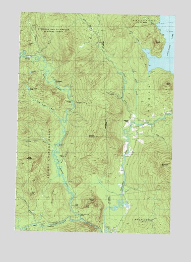
Wilsons Mills, ME USGS Topographic Map
Click on map above to begin viewing in our Map Viewer.

This topographic map contains these locations and features:
Feature Name Type Latitude Longitude GNIS ID View Map
Abbott BrookStreamN44.9384°W71.0306°561049View Map
Abbott Brook DikeDamN44.9673°W71.0202°1774288View Map
Alder BrookStreamN44.8792°W71.1081°865213View Map
Alice LedgeCliffN44.8898°W71.0734°871085View Map
Atkinson and Gilmanton Academy GrantCivilN44.9900°W71.1241°871100View Map
Aziscohos LakeReservoirN44.9731°W71.0155°561377View Map
Aziscohos MountainSummitN44.9141°W71.0018°561378View Map
Bennett BridgeBridgeN44.9191°W71.0384°1907922View Map
Bennett BrookStreamN44.9153°W71.0381°562053View Map
Bennett BrookStreamN44.8770°W71.1148°865542View Map
Black MountainSummitN44.9139°W71.1134°865630View Map
Bog BrookStreamN44.9806°W71.0256°562650View Map
Clark BrookStreamN44.9376°W71.0190°564021View Map
Cold BrookStreamN44.9953°W71.0145°564178View Map
College FarmLocaleN44.9192°W71.0867°866287View Map
Dart Wentworth SpringSpringN44.8845°W71.0712°871087View Map
Dead Diamond RiverStreamN44.8756°W71.0504°866512View Map
Diamond PeaksSummitN44.8926°W71.0617°866571View Map
East Horne BrookStreamN44.9748°W71.1087°866713View Map
Emerys MiserySummitN44.9841°W71.0151°565910View Map
Finnsons CliffCliffN44.9817°W71.1170°871094View Map
Halfmoon MountainSummitN44.9303°W71.0615°867313View Map
Hell GateLocaleN44.9742°W71.1165°867452View Map
Hell Gate PondLakeN44.9657°W71.1153°871093View Map
Horne BrookStreamN44.9748°W71.1090°867603View Map
Lamb Valley BrookStreamN44.9381°W71.0892°867934View Map
Lamb Valley PondLakeN44.9559°W71.1163°867935View Map
Lincoln Plantation CemeteryCemeteryN44.9290°W71.0284°2736372View Map
Linda LedgeCliffN44.8906°W71.0662°871086View Map
Little Abbott BrookStreamN44.9423°W71.0298°569653View Map
Little Dead Diamond RiverStreamN44.9753°W71.1231°868056View Map
Loomis Valley BrookStreamN44.9217°W71.0956°868154View Map
Magalloway Fire DepartmentBuildingN44.8757°W71.0424°2553042View Map
Meadow BrookStreamN44.8962°W71.0392°579068View Map
Merrill BrookStreamN44.9156°W71.0926°868394View Map
Miller-Quinn Landing Strip (historical)AirportN44.8773°W71.0531°871088View Map
Monahans BathtubBendN44.9273°W71.0915°871089View Map
Parker HillSummitN44.9602°W71.0059°572981View Map
Rands RockSummitN44.8959°W71.1120°871083View Map
Sams LookoutSummitN44.8789°W71.1031°871082View Map
Sanderson BrookStreamN44.9523°W71.0398°574862View Map
Second College GrantCivilN44.9129°W71.1071°871136View Map
SlewgundyLocaleN44.9606°W71.0945°871092View Map
Stoddards CabinLocaleN44.9278°W71.1004°871090View Map
Swift Diamond RiverStreamN44.8825°W71.0717°870316View Map
The HandPopulated PlaceN44.8798°W71.0915°873204View Map
Washburn BrookStreamN44.9498°W71.0806°871091View Map
West Branch Abbott BrookStreamN44.9895°W71.0612°870743View Map
Wilsons MillsPopulated PlaceN44.9381°W71.0354°579842View Map
Wilsons Mills Fire DepartmentBuildingN44.9319°W71.0293°2553030View Map
Wilsons Mills Post OfficePost OfficeN44.9301°W71.0284°1908259View Map
Windey RidgeRidgeN44.8962°W71.0940°871084View Map

Note: Coordinates in the location and feature list above are referenced to NAD83 datum.


Copyright (C) 2008-2025 Ryan Niemi / Sunset Dynamics ... All Rights Reserved