TopoQuest Logo
Do you find TopoQuest useful?
Help keep TopoQuest running and adding new maps/features by donating!
Bitcoin:  19c7KJd3qBynnjoSw5npx9KScwjBe4ifkT
Litecoin:  LXs6TkuXGGXo1vDsWCkWVdjQX94eUKd6ui
Home View Maps Find Maps Find Places Resources & Links


Esperanza Mill, Arizona Topographic Map

USGS Map Title: Esperanza Mill, AZ
USGS Map MRC: 31111G1
DRG (GeoTIFF) Download: o31111g1.tif


Neighboring USGS Topographic Map Quads:


  Samaniego Peak, AZ  
31111H2
 

  Twin Buttes, AZ  
31111H1
 

  Sahuarita, AZ  
31110H8
 

  Batamote Hills, AZ  
31111G2
 

  Esperanza Mill, AZ  
31111G1
 

  Green Valley, AZ  
31110G8
 

  Saucito Mountain, AZ  
31111F2
 

  Amado, AZ  
31111F1
 

  Mount Hopkins, AZ  
31110F8


Map MRC Location:

N32°
W112°
N32°
W111°
H8 H7 H6 H5 H4 H3 H2 H1
G8 G7 G6 G5 G4 G3 G2 G1
F8 F7 F6 F5 F4 F3 F2 F1
E8 E7 E6 E5 E4 E3 E2 E1
D8 D7 D6 D5 D4 D3 D2 D1
C8 C7 C6 C5 C4 C3 C2 C1
B8 B7 B6 B5 B4 B3 B2 B1
A8 A7 A6 A5 A4 A3 A2 A1
N31°
W112°
N31°
W111°

Esperanza Mill, AZ USGS 1:24K Topographic Map Preview:
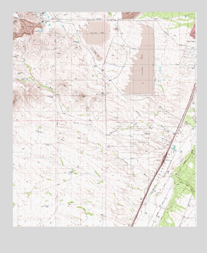
Esperanza Mill, AZ USGS Topographic Map
Click on map above to begin viewing in our Map Viewer.

This topographic map contains these locations and features:
Feature Name Type Latitude Longitude GNIS ID View Map
Agua Caliente CanyonValleyN31.7547°W111.0347°25480View Map
Amargosa WashArroyoN31.8654°W111.0909°15261View Map
Ball TankReservoirN31.7963°W111.0608°15272View Map
Canoa InterchangeCrossingN31.7898°W111.0215°15297View Map
Canoa Railroad StationBuildingN31.7684°W111.0201°15299View Map
Canoa RanchLocaleN31.7937°W111.0156°15298View Map
Canoa Ranch Golf ClubLocaleN31.7891°W111.0328°2622975View Map
Demetrie WashStreamN31.8045°W111.0062°3838View Map
Demetrie WellWellN31.8043°W111.0331°15328View Map
Desert Hills Golf Club of Green ValleyLocaleN31.8350°W111.0093°2622969View Map
Desert Hills Golf CourseLocaleN31.8350°W111.0093°43340View Map
Desert Hills Lutheran ChurchChurchN31.8384°W111.0166°2623069View Map
Duval LakeReservoirN31.8642°W111.1056°15340View Map
Duval Leach Flood Dam Number OneDamN31.8651°W111.1056°15341View Map
Escondido WashArroyoN31.7765°W111.0256°15356View Map
Esperanza MillMineN31.8695°W111.1040°15358View Map
Esperanza TankReservoirN31.8388°W111.1220°15360View Map
Esperanza WashStreamN31.8043°W111.0176°4490View Map
Esperanza WellWellN31.8487°W111.1223°15361View Map
Gemelo TankReservoirN31.8262°W111.0976°15376View Map
Gordo TankReservoirN31.7818°W111.0867°15379View Map
Green Valley Census Designated PlaceCensusN31.8437°W111.0172°2408329View Map
Green Valley Fire DepartmentBuildingN31.8227°W111.0417°2622548View Map
Hollywood TankReservoirN31.8578°W111.0800°15396View Map
KEZG-FM (Green Valley)TowerN31.7934°W111.0390°43352View Map
Madera Canyon WashArroyoN31.7820°W111.0162°37389View Map
New TankReservoirN31.8437°W111.0699°15483View Map
Roades Ranch (historical)LocaleN31.7834°W111.0506°24054View Map
Salcedo TankReservoirN31.7625°W111.1004°15562View Map
Salcedo WellWellN31.7565°W111.0631°15563View Map
San Ignacio Golf ClubLocaleN31.8079°W111.0200°2622973View Map
Sierrita MillMineN31.8737°W111.1081°15593View Map
Sierrita Tailings DamDamN31.8501°W111.0506°15596View Map
Tinaja WashStreamN31.8345°W111.1118°12488View Map
Vally Presbyterian ChurchChurchN31.8294°W111.0159°2623342View Map
White Iron CanyonValleyN31.8337°W111.1115°13634View Map
Wino TankReservoirN31.8278°W111.0618°20624View Map
Wire Corral TankReservoirN31.7981°W111.0984°20625View Map

Note: Coordinates in the location and feature list above are referenced to NAD83 datum.


Copyright (C) 2008-2025 Ryan Niemi / Sunset Dynamics ... All Rights Reserved