TopoQuest Logo
Do you find TopoQuest useful?
Help keep TopoQuest running and adding new maps/features by donating!
Bitcoin:  19c7KJd3qBynnjoSw5npx9KScwjBe4ifkT
Litecoin:  LXs6TkuXGGXo1vDsWCkWVdjQX94eUKd6ui
Home View Maps Find Maps Find Places Resources & Links


Twin Buttes, Arizona Topographic Map

USGS Map Title: Twin Buttes, AZ
USGS Map MRC: 31111H1
DRG (GeoTIFF) Download: o31111h1.tif


Neighboring USGS Topographic Map Quads:


  San Xavier Mission SW, AZ  
32111A2
 

  San Xavier Mission, AZ  
32111A1
 

  Tucson SW, AZ  
32110A8
 

  Samaniego Peak, AZ  
31111H2
 

  Twin Buttes, AZ  
31111H1
 

  Sahuarita, AZ  
31110H8
 

  Batamote Hills, AZ  
31111G2
 

  Esperanza Mill, AZ  
31111G1
 

  Green Valley, AZ  
31110G8


Map MRC Location:

N32°
W112°
N32°
W111°
H8 H7 H6 H5 H4 H3 H2 H1
G8 G7 G6 G5 G4 G3 G2 G1
F8 F7 F6 F5 F4 F3 F2 F1
E8 E7 E6 E5 E4 E3 E2 E1
D8 D7 D6 D5 D4 D3 D2 D1
C8 C7 C6 C5 C4 C3 C2 C1
B8 B7 B6 B5 B4 B3 B2 B1
A8 A7 A6 A5 A4 A3 A2 A1
N31°
W112°
N31°
W111°

Twin Buttes, AZ USGS 1:24K Topographic Map Preview:
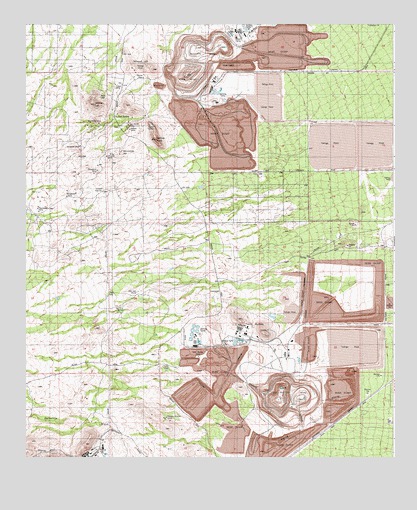
Twin Buttes, AZ USGS Topographic Map
Click on map above to begin viewing in our Map Viewer.

This topographic map contains these locations and features:
Feature Name Type Latitude Longitude GNIS ID View Map
Angelica WashArroyoN31.9651°W111.0637°15262View Map
Banner MineMineN31.9842°W111.0815°999View Map
Bobbie MineMineN31.9701°W111.0907°15284View Map
Dogtown MineMineN31.9512°W111.1104°15333View Map
Duval Commerce ParkLocaleN31.8978°W111.0020°2622382View Map
Esperanza Tailings DamDamN31.9834°W111.0673°37292View Map
Flying Diamond AirportAirportN31.9372°W111.1215°2623648View Map
Helmet PeakSummitN31.9667°W111.0815°5719View Map
Helmet Peak Volunteer Fire DepartmentBuildingN31.9697°W111.0934°2622549View Map
Indian KitchenSummitN31.9515°W111.0990°15404View Map
KGMS-FM (Green Valley)TowerN31.9109°W111.0445°45190View Map
KQYT-FM (Green Valley)TowerN31.9109°W111.0445°45191View Map
Marjorie WashArroyoN31.9810°W111.0884°23956View Map
Mineral HillSummitN31.9867°W111.0812°8100View Map
Mineral Hill MineMineN31.9867°W111.0882°15469View Map
Mission MineMineN31.9917°W111.0631°15472View Map
Mission Tailings Dam Number OneDamN31.9834°W111.0673°15474View Map
Missions Tailings Dam Number TwoDamN31.9834°W111.0673°15475View Map
Olivette MineMineN31.9626°W111.0965°15488View Map
Paymaster MineMineN31.9467°W111.1215°15515View Map
Pima MineMineN31.9823°W111.0637°9441View Map
Prosperity MineMineN31.9573°W111.1018°15534View Map
Punta del AguaLocaleN31.9501°W111.1007°24051View Map
Rodolfo WashArroyoN31.9792°W111.0798°15551View Map
Ruby Star AirparkAirportN31.9085°W111.1220°2623652View Map
Ruby-Star RanchLocaleN31.9220°W111.0870°10576View Map
San XavierPopulated PlaceN31.9737°W111.0951°10864View Map
San Xavier MineMineN31.9715°W111.0904°15570View Map
Senator Morgan MineMineN31.8862°W111.0779°15588View Map
Swastika MineMineN31.9651°W111.1068°15621View Map
Twin ButtesPopulated PlaceN31.9026°W111.0606°24663View Map
Twin ButtesSummitN31.9115°W111.0451°12929View Map
Twin Buttes CemeteryCemeteryN31.9042°W111.0669°15649View Map
Twin Buttes MineMineN31.8931°W111.0356°15650View Map
Twin Buttes Tailings DamDamN31.8834°W111.0340°15651View Map
University MineMineN31.9715°W111.1020°15655View Map
Vulcan MineMineN31.9826°W111.0948°15671View Map
Whitcomb HillSummitN31.9634°W111.0923°15674View Map
White HillSummitN31.9767°W111.1020°20620View Map

Note: Coordinates in the location and feature list above are referenced to NAD83 datum.


Copyright (C) 2008-2024 Ryan Niemi / Sunset Dynamics ... All Rights Reserved