TopoQuest Logo
Do you find TopoQuest useful?
Help keep TopoQuest running and adding new maps/features by donating!
Bitcoin:  19c7KJd3qBynnjoSw5npx9KScwjBe4ifkT
Litecoin:  LXs6TkuXGGXo1vDsWCkWVdjQX94eUKd6ui
Home View Maps Find Maps Find Places Resources & Links


Etna, Wyoming Topographic Map

USGS Map Title: Etna, WY
USGS Map MRC: 43111A1
DRG (GeoTIFF) Download: o43111a1.tif


Neighboring USGS Topographic Map Quads:


  Poker Peak, ID  
43111B2
 

  Alpine, WY  
43111B1
 

  Ferry Peak, WY  
43110B8
 

  Tincup Mountain, ID  
43111A2
 

  Etna, WY  
43111A1
 

  Stewart Peak, WY  
43110A8
 

  Stump Peak, ID  
42111H2
 

  Thayne West, WY  
42111H1
 

  Thayne East, WY  
42110H8


Map MRC Location:

N44°
W112°
N44°
W111°
H8 H7 H6 H5 H4 H3 H2 H1
G8 G7 G6 G5 G4 G3 G2 G1
F8 F7 F6 F5 F4 F3 F2 F1
E8 E7 E6 E5 E4 E3 E2 E1
D8 D7 D6 D5 D4 D3 D2 D1
C8 C7 C6 C5 C4 C3 C2 C1
B8 B7 B6 B5 B4 B3 B2 B1
A8 A7 A6 A5 A4 A3 A2 A1
N43°
W112°
N43°
W111°

Etna, WY USGS 1:24K Topographic Map Preview:
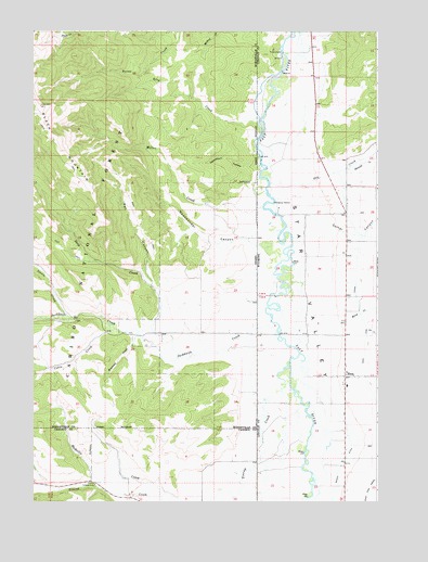
Etna, WY USGS Topographic Map
Click on map above to begin viewing in our Map Viewer.

This topographic map contains these locations and features:
Feature Name Type Latitude Longitude GNIS ID View Map
Amesville CemeteryCemeteryN43.0914°W111.0334°2774428View Map
Baker DitchCanalN43.0102°W111.0130°1597874View Map
Birch CreekStreamN43.0469°W111.0113°1598190View Map
Cabin CreekStreamN43.0460°W111.0974°378646View Map
Corral CanyonValleyN43.0730°W111.0324°1598907View Map
Deep CreekStreamN43.0383°W111.0730°380384View Map
Double L Ranch AirportAirportN43.0799°W111.0327°2717246View Map
Dry CreekStreamN43.0849°W111.0385°1599333View Map
EtnaPopulated PlaceN43.0333°W111.0110°1599637View Map
Etna Census Designated PlaceCensusN43.0334°W111.0129°2408093View Map
Etna Post OfficePost OfficeN43.0326°W111.0124°2767863View Map
Freedom Air Ranch AirportAirportN43.0420°W111.0392°2443888View Map
Grouse CreekStreamN43.0019°W111.0885°382726View Map
Hawthorn HollowValleyN43.0894°W111.0424°382979View Map
Hawthorn HollowValleyN43.0894°W111.0419°1600237View Map
Jackknife CreekStreamN43.0480°W111.0393°383825View Map
King CreekStreamN43.1019°W111.0433°384228View Map
Lee CreekStreamN43.0455°W111.0038°1600875View Map
Metcalf SchoolSchoolN43.0333°W111.0110°1795564View Map
Miller CreekStreamN43.0719°W111.0352°1601461View Map
Miller CreekStreamN43.0785°W111.0416°386965View Map
Newswander CanyonValleyN43.0691°W111.0472°387545View Map
Newswander CanyonValleyN43.0721°W111.0352°1601692View Map
Pat CanyonValleyN43.0580°W111.0819°388258View Map
Raymond CreekStreamN43.0452°W111.0874°389175View Map
Squaw CreekStreamN43.0491°W111.1119°391286View Map
Star ValleyValleyN43.1233°W111.0277°1604492View Map
Stewart CreekStreamN43.0885°W111.0110°1603359View Map
Tincup CampgroundLocaleN43.0046°W111.1027°392177View Map
Tincup CreekStreamN43.0366°W111.0324°392180View Map

Note: Coordinates in the location and feature list above are referenced to NAD83 datum.


Copyright (C) 2008-2024 Ryan Niemi / Sunset Dynamics ... All Rights Reserved