TopoQuest Logo
Do you find TopoQuest useful?
Help keep TopoQuest running and adding new maps/features by donating!
Bitcoin:  19c7KJd3qBynnjoSw5npx9KScwjBe4ifkT
Litecoin:  LXs6TkuXGGXo1vDsWCkWVdjQX94eUKd6ui
Home View Maps Find Maps Find Places Resources & Links


Eureka, Kansas Topographic Map

USGS Map Title: Eureka, KS
USGS Map MRC: 37096G3
DRG (GeoTIFF) Download: o37096g3.tif


Neighboring USGS Topographic Map Quads:


  Lapland, KS  
37096H4
 

  Eureka NE, KS  
37096H3
 

  Hamilton, KS  
37096H2
 

  Reece, KS  
37096G4
 

  Eureka, KS  
37096G3
 

  Tonovay, KS  
37096G2
 

  Piedmont NW, KS  
37096F4
 

  Piedmont NE, KS  
37096F3
 

  Severy North, KS  
37096F2


Map MRC Location:

N38°
W97°
N38°
W96°
H8 H7 H6 H5 H4 H3 H2 H1
G8 G7 G6 G5 G4 G3 G2 G1
F8 F7 F6 F5 F4 F3 F2 F1
E8 E7 E6 E5 E4 E3 E2 E1
D8 D7 D6 D5 D4 D3 D2 D1
C8 C7 C6 C5 C4 C3 C2 C1
B8 B7 B6 B5 B4 B3 B2 B1
A8 A7 A6 A5 A4 A3 A2 A1
N37°
W97°
N37°
W96°

Eureka, KS USGS 1:24K Topographic Map Preview:
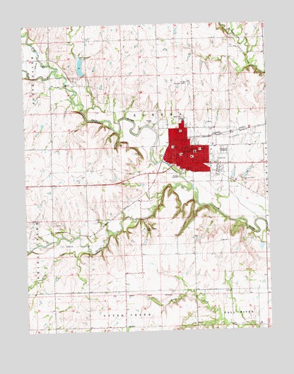
Eureka, KS USGS Topographic Map
Click on map above to begin viewing in our Map Viewer.

This topographic map contains these locations and features:
Feature Name Type Latitude Longitude GNIS ID View Map
Bible Baptist ChurchChurchN37.8300°W96.2931°2025290View Map
Christ Lutheran ChurchChurchN37.8213°W96.2930°2025291View Map
Christian and Congregational ChurchChurchN37.8210°W96.2931°2688851View Map
Christian Hills CampLocaleN37.7914°W96.3142°474638View Map
Chuckwagon Recreational Vehicle ParkLocaleN37.8165°W96.2802°2692555View Map
City of EurekaCivilN37.8261°W96.2888°485572View Map
East Branch Fall RiverStreamN37.8567°W96.3575°474424View Map
EurekaPopulated PlaceN37.8239°W96.2892°474640View Map
Eureka Church of ChristChurchN37.8173°W96.2945°2025292View Map
Eureka City HallBuildingN37.8217°W96.2959°2693337View Map
Eureka Country ClubLocaleN37.8368°W96.3083°2694559View Map
Eureka DownsLocaleN37.8203°W96.2768°480976View Map
Eureka Fire DepartmentBuildingN37.8185°W96.2938°2111308View Map
Eureka Junior / Senior High SchoolSchoolN37.8279°W96.2795°480973View Map
Eureka Junior High SchoolSchoolN37.8228°W96.2878°480974View Map
Eureka Kindergarten (historical)SchoolN37.8237°W96.2920°2437499View Map
Eureka Oil FieldOilfieldN37.8286°W96.2558°474648View Map
Eureka Post OfficePost OfficeN37.8214°W96.2959°2025289View Map
Eureka Public LibraryBuildingN37.8249°W96.2937°2025300View Map
Eureka Senior CenterBuildingN37.8207°W96.2959°2692556View Map
Eureka Seventh Day Adventist ChurchChurchN37.8183°W96.2738°2689290View Map
First Baptist ChurchChurchN37.8235°W96.2931°2025293View Map
First Church of GodChurchN37.8210°W96.2979°2025294View Map
First United Methodist ChurchChurchN37.8239°W96.2944°2025298View Map
Greenwood CemeteryCemeteryN37.8231°W96.2728°474644View Map
Greenwood County CourthouseBuildingN37.8217°W96.2947°2625096View Map
Greenwood County Emergency Medical ServicesBuildingN37.8148°W96.2796°2696504View Map
Greenwood County FairgroundsLocaleN37.8205°W96.2768°2692998View Map
Greenwood County Health DepartmentBuildingN37.8193°W96.2958°2695014View Map
Greenwood County Historical Society MuseumBuildingN37.8225°W96.2951°2694905View Map
Greenwood County HospitalHospitalN37.8357°W96.2936°2025297View Map
Greenwood County JailBuildingN37.8218°W96.2947°2504305View Map
Greenwood County Sheriff's OfficeBuildingN37.8216°W96.2947°2504041View Map
Jefferson Street Baptist ChurchChurchN37.8167°W96.2794°2025295View Map
Kansas Highway Patrol Troop H GreenwoodBuildingN37.8218°W96.2947°2504131View Map
Kingdom Hall of Jehovah's WitnessesChurchN37.8186°W96.2973°2025296View Map
Kitty CreekStreamN37.7831°W96.3428°474636View Map
KOTE - FM (Eureka)BuildingN37.7912°W96.2902°2625297View Map
Landergin (historical)Populated PlaceN37.7889°W96.3392°484960View Map
Lions ParkParkN37.8131°W96.2764°474639View Map
Lt William M Milliken AirportAirportN37.8513°W96.2904°474645View Map
Marshall Elementary SchoolSchoolN37.8295°W96.2796°2437511View Map
Matt Samuels Community BuildingBuildingN37.8184°W96.2797°2692948View Map
Mulberry Elementary School (historical)SchoolN37.8206°W96.2897°2437466View Map
New Life Assembly of God ChurchChurchN37.8316°W96.2947°2689131View Map
North Side SchoolSchoolN37.8314°W96.2947°474641View Map
Prince of Peace Pentecostal Holiness ChurchChurchN37.8259°W96.2945°2689150View Map
Random Elementary School (historical)SchoolN37.8247°W96.2986°474642View Map
Reece Oil FieldOilfieldN37.7917°W96.3725°474637View Map
Sacred Heart Catholic ChurchChurchN37.8236°W96.2923°2025299View Map
Sacred Heart School (historical)SchoolN37.8242°W96.2919°474643View Map
Spring CreekStreamN37.8078°W96.2894°474635View Map
Township of EurekaCivilN37.8401°W96.3072°474419View Map
West Branch Fall RiverStreamN37.8567°W96.3575°474418View Map
Yates Memorial Seventh - day Adventist SchoolSchoolN37.8086°W96.2587°2437453View Map

Note: Coordinates in the location and feature list above are referenced to NAD83 datum.


Copyright (C) 2008-2025 Ryan Niemi / Sunset Dynamics ... All Rights Reserved