TopoQuest Logo
Do you find TopoQuest useful?
Help keep TopoQuest running and adding new maps/features by donating!
Bitcoin:  19c7KJd3qBynnjoSw5npx9KScwjBe4ifkT
Litecoin:  LXs6TkuXGGXo1vDsWCkWVdjQX94eUKd6ui
Home View Maps Find Maps Find Places Resources & Links


Eveleth, Minnesota Topographic Map

USGS Map Title: Eveleth, MN
USGS Map MRC: 47092D5
DRG (GeoTIFF) Download: o47092d5.tif


Neighboring USGS Topographic Map Quads:


  Kinney, MN  
47092E6
 

  Virginia, MN  
47092E5
 

  McKinley, MN  
47092E4
 

  Kirk, MN  
47092D6
 

  Eveleth, MN  
47092D5
 

  Gilbert, MN  
47092D4
 

  Casco, MN  
47092C6
 

  Zim, MN  
47092C5
 

  Central Lakes, MN  
47092C4


Map MRC Location:

N48°
W93°
N48°
W92°
H8 H7 H6 H5 H4 H3 H2 H1
G8 G7 G6 G5 G4 G3 G2 G1
F8 F7 F6 F5 F4 F3 F2 F1
E8 E7 E6 E5 E4 E3 E2 E1
D8 D7 D6 D5 D4 D3 D2 D1
C8 C7 C6 C5 C4 C3 C2 C1
B8 B7 B6 B5 B4 B3 B2 B1
A8 A7 A6 A5 A4 A3 A2 A1
N47°
W93°
N47°
W92°

Eveleth, MN USGS 1:24K Topographic Map Preview:
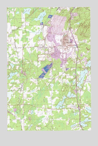
Eveleth, MN USGS Topographic Map
Click on map above to begin viewing in our Map Viewer.

This topographic map contains these locations and features:
Feature Name Type Latitude Longitude GNIS ID View Map
Adams PitMineN47.4694°W92.5477°660624View Map
Arrowhead Health Care CenterHospitalN47.4653°W92.5403°2126476View Map
Auburn PitMineN47.4996°W92.5343°660696View Map
Borg LakeLakeN47.3791°W92.5910°660853View Map
Burns MineMineN47.4513°W92.5138°660913View Map
Camp OlcottLocaleN47.3785°W92.5127°660946View Map
Camp WarrenLocaleN47.3872°W92.5041°660949View Map
City of EvelethCivilN47.4637°W92.5440°2394712View Map
City of Iron JunctionCivilN47.4190°W92.6084°2395435View Map
City of LeonidasCivilN47.4678°W92.5674°2395683View Map
De ForestPopulated PlaceN47.4599°W92.5794°661098View Map
Duluth Clinic-EvelethHospitalN47.4617°W92.5356°2126478View Map
Elbow LakeLakeN47.4289°W92.6225°661194View Map
Emmanuel Baptist ChurchChurchN47.4889°W92.5292°2123712View Map
EvelethPopulated PlaceN47.4624°W92.5399°661233View Map
Eveleth Ambulance ServiceBuildingN47.4646°W92.5385°2721384View Map
Eveleth CemeteryCemeteryN47.4778°W92.5342°2678346View Map
Eveleth City HallBuildingN47.4628°W92.5389°2126479View Map
Eveleth Fire DepartmentBuildingN47.4645°W92.5385°2126473View Map
Eveleth Golf CourseLocaleN47.4244°W92.5199°661234View Map
Eveleth NurseryLocaleN47.3988°W92.5255°661235View Map
Eveleth Police DeptBuildingN47.4628°W92.5390°2126480View Map
Eveleth Post OfficePost OfficeN47.4636°W92.5383°2126471View Map
Eveleth Public LibraryBuildingN47.4625°W92.5353°2126472View Map
Eveleth-Gilbert Senior High SchoolSchoolN47.4644°W92.5314°2126475View Map
Eveleth-Virginia Municipal AirportAirportN47.4262°W92.5033°660607View Map
Fayal Fire DepartmentBuildingN47.4367°W92.5018°2666568View Map
Fayal Number Two PitMineN47.4549°W92.5413°661251View Map
Fayal PitMineN47.4549°W92.5291°661252View Map
Fayal Police DepartmentBuildingN47.4367°W92.5018°2758758View Map
Fayal PondLakeN47.4598°W92.5232°661253View Map
Fayal SchoolSchoolN47.4608°W92.5341°661254View Map
First Apostolic Lutheran ChurchChurchN47.4925°W92.5194°2123713View Map
Franklin Elementary SchoolSchoolN47.4658°W92.5317°2126474View Map
Fresenius Medical CareHospitalN47.4617°W92.5356°2126477View Map
GenoaPopulated PlaceN47.4644°W92.5088°661347View Map
Half Moon LakeLakeN47.3803°W92.5066°661411View Map
Harvey LakeLakeN47.3919°W92.5235°661435View Map
Horseshoe LakeLakeN47.4108°W92.5304°661505View Map
Hull-Nelson MineMineN47.4688°W92.5546°661514View Map
Iron JunctionPopulated PlaceN47.4188°W92.6035°661552View Map
Iron JunctionLocaleN47.4189°W92.6033°2123629View Map
Iron Post OfficePost OfficeN47.4175°W92.6045°2123628View Map
Kalleva IslandIslandN47.3997°W92.5460°661613View Map
Kapla LakeLakeN47.4151°W92.5869°661617View Map
KeenanPopulated PlaceN47.3833°W92.6044°661622View Map
Keenan LakeLakeN47.3937°W92.5884°661623View Map
LargoPopulated PlaceN47.4802°W92.5705°661689View Map
LeonidasPopulated PlaceN47.4616°W92.5719°661705View Map
Leonidas MineMineN47.4699°W92.5632°661706View Map
Lincoln SchoolSchoolN47.4674°W92.5366°661719View Map
Long LakeLakeN47.4019°W92.5451°661797View Map
Manganika LakeLakeN47.4903°W92.5743°661856View Map
Mashkenode LakeLakeN47.4956°W92.5957°661876View Map
Mesabi Range CollegeSchoolN47.4711°W92.5247°2126465View Map
MidwayPopulated PlaceN47.4910°W92.5257°661917View Map
Midway Post Office (historical)Post OfficeN47.4911°W92.5256°2117831View Map
Monroe ParkParkN47.4633°W92.5417°2126463View Map
Moon LakeLakeN47.3797°W92.5267°661944View Map
Morrow MineMineN47.4571°W92.5010°661968View Map
Mud LakeLakeN47.4232°W92.5256°661989View Map
Mud LakeLakeN47.4834°W92.5187°661991View Map
Northside ParkParkN47.4717°W92.5367°2126462View Map
Rainy JunctionPopulated PlaceN47.4985°W92.5452°662244View Map
RamshawPopulated PlaceN47.4274°W92.5813°662247View Map
Resurrection ChurchChurchN47.4625°W92.5383°2126469View Map
Saint Johns Episcopal ChurchChurchN47.4625°W92.5347°2126470View Map
Saint Marys LakeLakeN47.4283°W92.5132°662339View Map
Saint Marys Lake Wayside ParkParkN47.4206°W92.5211°2126612View Map
SnowdenPopulated PlaceN47.4552°W92.5505°662486View Map
Soutside ParkParkN47.4589°W92.5347°2126464View Map
SprucePopulated PlaceN47.4274°W92.5630°662523View Map
Spruce MineMineN47.4638°W92.5485°662526View Map
Township of ClintonCivilN47.4139°W92.6244°663827View Map
United in Christ Lutheran ChurchChurchN47.4611°W92.5375°2126468View Map
United Methodist ChurchChurchN47.4617°W92.5375°2126467View Map
United States Hockey Hall of FameBuildingN47.4717°W92.5286°2126466View Map
Virginia Assembly of God ChurchChurchN47.4906°W92.5222°2123710View Map
Virginia MineMineN47.4774°W92.5555°662721View Map
Warren LakeLakeN47.3895°W92.5076°662742View Map
WEVE-AM (Eveleth)TowerN47.4777°W92.5335°662910View Map
WolfPopulated PlaceN47.4505°W92.6088°662817View Map

Note: Coordinates in the location and feature list above are referenced to NAD83 datum.


Copyright (C) 2008-2025 Ryan Niemi / Sunset Dynamics ... All Rights Reserved