TopoQuest Logo
Do you find TopoQuest useful?
Help keep TopoQuest running and adding new maps/features by donating!
Bitcoin:  19c7KJd3qBynnjoSw5npx9KScwjBe4ifkT
Litecoin:  LXs6TkuXGGXo1vDsWCkWVdjQX94eUKd6ui
Home View Maps Find Maps Find Places Resources & Links


Everly, Iowa Topographic Map

USGS Map Title: Everly, IA
USGS Map MRC: 43095B3
DRG (GeoTIFF) Download: o43095b3.tif


Neighboring USGS Topographic Map Quads:


  May City, IA  
43095C4
 

  Lake Park SE, IA  
43095C3
 

  Milford, IA  
43095C2
 

  Hartley, IA  
43095B4
 

  Everly, IA  
43095B3
 

  Spencer, IA  
43095B2
 

  Hartley SW, IA  
43095A4
 

  Royal, IA  
43095A3
 

  Greenville, IA  
43095A2


Map MRC Location:

N44°
W96°
N44°
W95°
H8 H7 H6 H5 H4 H3 H2 H1
G8 G7 G6 G5 G4 G3 G2 G1
F8 F7 F6 F5 F4 F3 F2 F1
E8 E7 E6 E5 E4 E3 E2 E1
D8 D7 D6 D5 D4 D3 D2 D1
C8 C7 C6 C5 C4 C3 C2 C1
B8 B7 B6 B5 B4 B3 B2 B1
A8 A7 A6 A5 A4 A3 A2 A1
N43°
W96°
N43°
W95°

Everly, IA USGS 1:24K Topographic Map Preview:
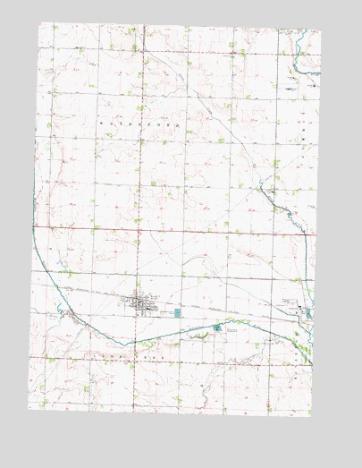
Everly, IA USGS Topographic Map
Click on map above to begin viewing in our Map Viewer.

This topographic map contains these locations and features:
Feature Name Type Latitude Longitude GNIS ID View Map
Berends FarmLocaleN43.1914°W95.3300°2727459View Map
City of EverlyCivilN43.1619°W95.3198°2394714View Map
Clay Central - Everly Elementary School at EverlySchoolN43.1586°W95.3236°2719794View Map
Clay Central - Everly Junior / Senior High School at EverlySchoolN43.1586°W95.3240°1944358View Map
Cromwell Center Post Office (historical)Post OfficeN43.2416°W95.2586°1944229View Map
EverlyLocaleN43.1616°W95.3281°1944353View Map
EverlyPopulated PlaceN43.1600°W95.3275°456447View Map
Everly City HallBuildingN43.1594°W95.3269°1944350View Map
Everly City ParkParkN43.1611°W95.3278°1944359View Map
Everly Fire and RescueBuildingN43.1590°W95.3277°2577446View Map
Everly Post OfficePost OfficeN43.1597°W95.3269°1944351View Map
Everly Public LibraryBuildingN43.1605°W95.3269°1944349View Map
Fairchild FarmLocaleN43.1428°W95.2625°2727453View Map
Farmers Co-op ElevatorLocaleN43.1644°W95.3272°1944352View Map
First Reformed ChurchChurchN43.2405°W95.2886°456608View Map
First Reformed Church CemeteryCemeteryN43.2399°W95.2882°1944357View Map
Foss FarmsLocaleN43.1864°W95.2900°2727460View Map
Geerdes FarmLocaleN43.1403°W95.3197°2727454View Map
Hildreth FarmLocaleN43.2228°W95.3303°2727458View Map
Hope Lutheran ChurchChurchN43.1602°W95.3206°1944355View Map
Jensen FarmsLocaleN43.1756°W95.2872°2611861View Map
Kirksey FarmsLocaleN43.1797°W95.3275°2727455View Map
Kruse FarmsLocaleN43.1261°W95.3419°2727457View Map
Lone Tree CemeteryCemeteryN43.1411°W95.3350°458581View Map
Ocheyedan River State Game RefugeParkN43.1452°W95.2525°459797View Map
Q B FarmLocaleN43.1975°W95.3375°2727456View Map
Saint Marys Catholic ChurchChurchN43.1564°W95.3278°1944354View Map
Scharnberg County ParkParkN43.1525°W95.2900°461460View Map
Schoeleman FarmsLocaleN43.1258°W95.2878°2727467View Map
Sewer CreekStreamN43.1533°W95.3511°461514View Map
Spring CreekStreamN43.1508°W95.2656°461882View Map
Sunny Brooks School (historical)SchoolN43.1611°W95.3278°1944360View Map
Township of Lone TreeCivilN43.1266°W95.3287°468302View Map
Township of WaterfordCivilN43.2123°W95.3286°468948View Map
Tuttle Marsh AreaParkN43.2166°W95.2739°1944235View Map
United Methodist ChurchChurchN43.1602°W95.3292°1944356View Map

Note: Coordinates in the location and feature list above are referenced to NAD83 datum.


Copyright (C) 2008-2024 Ryan Niemi / Sunset Dynamics ... All Rights Reserved