TopoQuest Logo
Do you find TopoQuest useful?
Help keep TopoQuest running and adding new maps/features by donating!
Bitcoin:  19c7KJd3qBynnjoSw5npx9KScwjBe4ifkT
Litecoin:  LXs6TkuXGGXo1vDsWCkWVdjQX94eUKd6ui
Home View Maps Find Maps Find Places Resources & Links


Fair Play, Missouri Topographic Map

USGS Map Title: Fair Play, MO
USGS Map MRC: 37093F5
DRG (GeoTIFF) Download: o37093f5.tif


Neighboring USGS Topographic Map Quads:


  Arnica, MO  
37093G6
 

  Humansville, MO  
37093G5
 

  Elkton, MO  
37093G4
 

  Bearcreek, MO  
37093F6
 

  Fair Play, MO  
37093F5
 

  Cliquot, MO  
37093F4
 

  Bona, MO  
37093E6
 

  Aldrich, MO  
37093E5
 

  Bolivar, MO  
37093E4


Map MRC Location:

N38°
W94°
N38°
W93°
H8 H7 H6 H5 H4 H3 H2 H1
G8 G7 G6 G5 G4 G3 G2 G1
F8 F7 F6 F5 F4 F3 F2 F1
E8 E7 E6 E5 E4 E3 E2 E1
D8 D7 D6 D5 D4 D3 D2 D1
C8 C7 C6 C5 C4 C3 C2 C1
B8 B7 B6 B5 B4 B3 B2 B1
A8 A7 A6 A5 A4 A3 A2 A1
N37°
W94°
N37°
W93°

Fair Play, MO USGS 1:24K Topographic Map Preview:
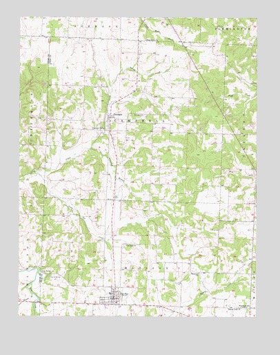
Fair Play, MO USGS Topographic Map
Click on map above to begin viewing in our Map Viewer.

This topographic map contains these locations and features:
Feature Name Type Latitude Longitude GNIS ID View Map
Barren Creek ChurchChurchN37.6289°W93.5083°713695View Map
Bismount ChurchChurchN37.6431°W93.5302°714277View Map
Bushy Creek CemeteryCemeteryN37.6553°W93.5688°715108View Map
Campbell BranchStreamN37.6950°W93.5866°715297View Map
Cave SpringSpringN37.6435°W93.6127°715537View Map
Cave Spring CemeteryCemeteryN37.6414°W93.6091°715543View Map
City of Fair PlayCivilN37.6332°W93.5768°2394724View Map
Consolidated School Number 7SchoolN37.6345°W93.5771°732738View Map
DunneganPopulated PlaceN37.7081°W93.5769°735587View Map
Dunnegan CemeteryCemeteryN37.7092°W93.5592°717193View Map
Dunnegan Post OfficePost OfficeN37.7075°W93.5783°2779536View Map
Dunnegan Rural Fire Department Station 1BuildingN37.7037°W93.5792°2621583View Map
Dunnegan School (historical)SchoolN37.7148°W93.5788°732733View Map
Dunnegan SpringSpringN37.7036°W93.5803°717196View Map
Fair PlayPopulated PlaceN37.6300°W93.5733°735611View Map
Fair Play Fire DepartmentBuildingN37.6301°W93.5724°2621757View Map
Fair Play Police DepartmentBuildingN37.6327°W93.5738°2752124View Map
Fair Play Post OfficePost OfficeN37.6318°W93.5781°2782588View Map
Hopkins School (historical)SchoolN37.6781°W93.5930°732730View Map
Jump Off CreekStreamN37.6848°W93.6169°720458View Map
Moore BranchStreamN37.6342°W93.6171°722566View Map
Mount Herman School (historical)SchoolN37.7320°W93.5160°732732View Map
New Home School (historical)SchoolN37.7017°W93.5399°732734View Map
New Hope School (historical)SchoolN37.6831°W93.5096°732735View Map
Pickel CemeteryCemeteryN37.6614°W93.5196°724302View Map
Pickel School (historical)SchoolN37.6542°W93.5244°732737View Map
Plum Grove ChurchChurchN37.7406°W93.5583°724667View Map
Plum Grove School (historical)SchoolN37.7367°W93.5633°732731View Map
Rock School (historical)SchoolN37.6800°W93.5488°732736View Map
Township of CampbellCivilN37.7070°W93.5644°767210View Map
Township of East MadisonCivilN37.6286°W93.5405°767213View Map
Township of West MadisonCivilN37.6304°W93.5952°767230View Map
Woodlawn SchoolLocaleN37.6292°W93.5035°729114View Map

Note: Coordinates in the location and feature list above are referenced to NAD83 datum.


Copyright (C) 2008-2024 Ryan Niemi / Sunset Dynamics ... All Rights Reserved