TopoQuest Logo
Do you find TopoQuest useful?
Help keep TopoQuest running and adding new maps/features by donating!
Bitcoin:  19c7KJd3qBynnjoSw5npx9KScwjBe4ifkT
Litecoin:  LXs6TkuXGGXo1vDsWCkWVdjQX94eUKd6ui
Home View Maps Find Maps Find Places Resources & Links


Falcon Village, Texas Topographic Map

USGS Map Title: Falcon Village, TX
USGS Map MRC: 26099E2
DRG (GeoTIFF) Download: o26099e2.tif


Neighboring USGS Topographic Map Quads:


  Beckwith Arm, TX  
26099F2
 

  Lopeno, TX  
26099F1


  Falcon Village, TX  
26099E2
 

  Salineno, TX  
26099E1


  Roma-Los Saenz West, TX  
26099D1


Map MRC Location:

N27°
W100°
N27°
W99°
H8 H7 H6 H5 H4 H3 H2 H1
G8 G7 G6 G5 G4 G3 G2 G1
F8 F7 F6 F5 F4 F3 F2 F1
E8 E7 E6 E5 E4 E3 E2 E1
D8 D7 D6 D5 D4 D3 D2 D1
C8 C7 C6 C5 C4 C3 C2 C1
B8 B7 B6 B5 B4 B3 B2 B1
A8 A7 A6 A5 A4 A3 A2 A1
N26°
W100°
N26°
W99°

Falcon Village, TX USGS 1:24K Topographic Map Preview:
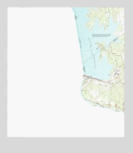
Falcon Village, TX USGS Topographic Map
Click on map above to begin viewing in our Map Viewer.

This topographic map contains these locations and features:
Feature Name Type Latitude Longitude GNIS ID View Map
Arroyo MedioValleyN26.6154°W99.1410°1329739View Map
Arroyo MorterosStreamN26.5245°W99.1264°1329744View Map
Chapeno CemeteryCemeteryN26.5348°W99.1495°1332661View Map
Chapeno Census Designated PlaceCensusN26.5509°W99.1339°2584620View Map
Chapeno Gaging StationLocaleN26.5328°W99.1548°1384334View Map
Falcon DamDamN26.5589°W99.1648°1335663View Map
Falcon Dam StationLocaleN26.5531°W99.1448°1377489View Map
Falcon State ParkParkN26.5801°W99.1428°1335667View Map
Falcon State Park Airport (historical)AirportN26.5867°W99.1381°1387420View Map
Falcon State Park TrailTrailN26.5801°W99.1431°2032747View Map
Falcon VillagePopulated PlaceN26.5614°W99.1345°1335668View Map
Falcon Village Census Designated PlaceCensusN26.5651°W99.1342°2408110View Map
Government CoveBayN26.5642°W99.1503°1377487View Map
H Cuellar Estates ColoniaPopulated PlaceN26.5614°W99.1264°2010844View Map
H. Cuellar Estates Census Designated PlaceCensusN26.5611°W99.1258°2584649View Map
International Falcon LakeReservoirN26.5587°W99.1620°1854285View Map
International Falcon Lake DamDamN26.5587°W99.1620°1854284View Map
Los Lobos Census Designated PlaceCensusN26.6065°W99.1613°2584687View Map
Miguel Garza ColoniaPopulated PlaceN26.5542°W99.1334°2010795View Map
United States Border Patrol StationBuildingN26.5532°W99.1444°2750775View Map

Note: Coordinates in the location and feature list above are referenced to NAD83 datum.


Copyright (C) 2008-2025 Ryan Niemi / Sunset Dynamics ... All Rights Reserved