TopoQuest Logo
Do you find TopoQuest useful?
Help keep TopoQuest running and adding new maps/features by donating!
Bitcoin:  19c7KJd3qBynnjoSw5npx9KScwjBe4ifkT
Litecoin:  LXs6TkuXGGXo1vDsWCkWVdjQX94eUKd6ui
Home View Maps Find Maps Find Places Resources & Links


Fall Creek, Texas Topographic Map

USGS Map Title: Fall Creek, TX
USGS Map MRC: 29099H2
DRG (GeoTIFF) Download: o29099h2.tif


Neighboring USGS Topographic Map Quads:


  Hunt, TX  
30099A3
 

  Kerrville, TX  
30099A2
 

  Legion, TX  
30099A1
 

  Echo Hill Ranch, TX  
29099H3
 

  Fall Creek, TX  
29099H2
 

  Center Point, TX  
29099H1
 

  A Bar A Ranch, TX  
29099G3
 

  Rock Cliff Reservoir, TX  
29099G2
 

  Bandera Pass, TX  
29099G1


Map MRC Location:

N30°
W100°
N30°
W99°
H8 H7 H6 H5 H4 H3 H2 H1
G8 G7 G6 G5 G4 G3 G2 G1
F8 F7 F6 F5 F4 F3 F2 F1
E8 E7 E6 E5 E4 E3 E2 E1
D8 D7 D6 D5 D4 D3 D2 D1
C8 C7 C6 C5 C4 C3 C2 C1
B8 B7 B6 B5 B4 B3 B2 B1
A8 A7 A6 A5 A4 A3 A2 A1
N29°
W100°
N29°
W99°

Fall Creek, TX USGS 1:24K Topographic Map Preview:
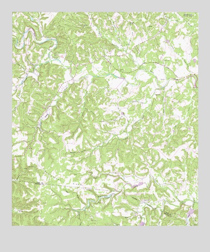
Fall Creek, TX USGS Topographic Map
Click on map above to begin viewing in our Map Viewer.

This topographic map contains these locations and features:
Feature Name Type Latitude Longitude GNIS ID View Map
Barclays Roost Airport (historical)AirportN29.9747°W99.1687°1387010View Map
Bushwhack CreekStreamN29.9722°W99.2237°1372855View Map
Calf RunStreamN29.9580°W99.2442°1331882View Map
Camp ChrysalisLocaleN29.9808°W99.2220°1331957View Map
Camp MaddoxLocaleN29.9824°W99.2481°1331987View Map
Coker HollowValleyN29.9638°W99.2399°1333069View Map
Cow CreekStreamN29.9558°W99.1264°1333542View Map
Crow CanyonValleyN29.8837°W99.1493°1373293View Map
Fall CreekStreamN29.9563°W99.1489°1335675View Map
Fall Creek Ranch AirportAirportN29.9088°W99.2091°2676581View Map
Falls LakeReservoirN29.8924°W99.1865°1863299View Map
Falls Lake DamDamN29.8934°W99.1841°1863298View Map
Grave HollowValleyN29.9438°W99.2023°1336860View Map
Habecker CemeteryCemeteryN29.9658°W99.1778°1337171View Map
Hog BranchStreamN29.8869°W99.1989°1337873View Map
Huntsberry RidgeRidgeN29.9033°W99.2178°1338316View Map
Indian CreekStreamN29.9483°W99.1589°1338399View Map
Kickapoo CampLocaleN29.9735°W99.2231°1339077View Map
Lambs CreekStreamN29.9602°W99.2078°1339588View Map
Lin ProngStreamN29.9005°W99.1712°1339935View Map
Little Lambs CreekStreamN29.9627°W99.1945°1340131View Map
Marshall CreekStreamN29.9774°W99.1731°1340993View Map
Mexican HollowValleyN29.9196°W99.1959°1341449View Map
Palmer CreekStreamN29.8891°W99.1364°1343470View Map
Panther HollowValleyN29.9687°W99.2348°1343545View Map
Peterson CreekStreamN29.9774°W99.1731°1343907View Map
Peterson SpringSpringN29.9941°W99.1709°1343910View Map
Prison CanyonValleyN29.8891°W99.1281°1375569View Map
Ranch HollowValleyN29.8838°W99.2058°1375624View Map
Real CemeteryCemeteryN29.9610°W99.1473°1344873View Map
Roden LakeReservoirN29.9004°W99.1612°1863552View Map
Roden Lake DamDamN29.9002°W99.1620°1863551View Map
South CreekStreamN29.9566°W99.1478°1347429View Map
Stone CreekStreamN29.9633°W99.1300°1347959View Map
T S Clements DamDamN29.8786°W99.1620°1863579View Map
T S Clements LakeReservoirN29.8786°W99.1620°1863580View Map
Turtle Creek CemeteryCemeteryN29.9755°W99.2198°1348927View Map
Turtle Creek Volunteer Fire DepartmentBuildingN29.9743°W99.2196°2551223View Map
Verde SpringsSpringN29.8752°W99.1753°1998593View Map
Walters DamDamN29.8852°W99.1286°1859092View Map
Walters LakeReservoirN29.8833°W99.1304°1859093View Map
West CreekStreamN29.9666°W99.1603°1376688View Map
Wolf CreekStreamN29.9360°W99.1670°1350459View Map

Note: Coordinates in the location and feature list above are referenced to NAD83 datum.


Copyright (C) 2008-2025 Ryan Niemi / Sunset Dynamics ... All Rights Reserved