TopoQuest Logo
Do you find TopoQuest useful?
Help keep TopoQuest running and adding new maps/features by donating!
Bitcoin:  19c7KJd3qBynnjoSw5npx9KScwjBe4ifkT
Litecoin:  LXs6TkuXGGXo1vDsWCkWVdjQX94eUKd6ui
Home View Maps Find Maps Find Places Resources & Links


Rock Cliff Reservoir, Texas Topographic Map

USGS Map Title: Rock Cliff Reservoir, TX
USGS Map MRC: 29099G2
DRG (GeoTIFF) Download: o29099g2.tif


Neighboring USGS Topographic Map Quads:


  Echo Hill Ranch, TX  
29099H3
 

  Fall Creek, TX  
29099H2
 

  Center Point, TX  
29099H1
 

  A Bar A Ranch, TX  
29099G3
 

  Rock Cliff Reservoir, TX  
29099G2
 

  Bandera Pass, TX  
29099G1
 

  Tarpley, TX  
29099F3
 

  Tarpley Pass, TX  
29099F2
 

  Bandera, TX  
29099F1


Map MRC Location:

N30°
W100°
N30°
W99°
H8 H7 H6 H5 H4 H3 H2 H1
G8 G7 G6 G5 G4 G3 G2 G1
F8 F7 F6 F5 F4 F3 F2 F1
E8 E7 E6 E5 E4 E3 E2 E1
D8 D7 D6 D5 D4 D3 D2 D1
C8 C7 C6 C5 C4 C3 C2 C1
B8 B7 B6 B5 B4 B3 B2 B1
A8 A7 A6 A5 A4 A3 A2 A1
N29°
W100°
N29°
W99°

Rock Cliff Reservoir, TX USGS 1:24K Topographic Map Preview:
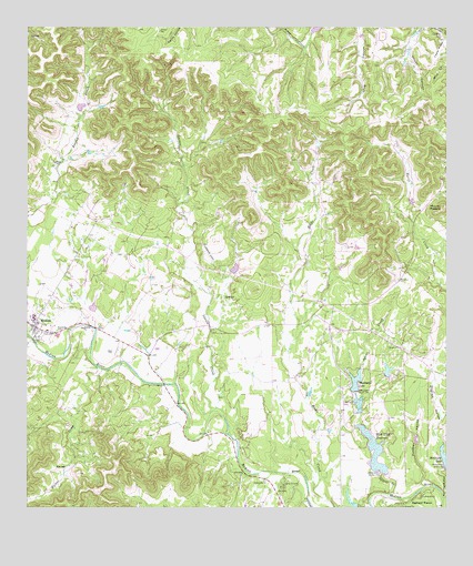
Rock Cliff Reservoir, TX USGS Topographic Map
Click on map above to begin viewing in our Map Viewer.

This topographic map contains these locations and features:
Feature Name Type Latitude Longitude GNIS ID View Map
Bandera County Constable's Office Precinct 3BuildingN29.7978°W99.2477°2750709View Map
Boazman LakeReservoirN29.8036°W99.1887°1864086View Map
Boazman Lake DamDamN29.8036°W99.1887°1864085View Map
Camp SionitoLocaleN29.7555°W99.1742°1353674View Map
Flying L AirportAirportN29.7563°W99.1488°2675969View Map
Hadfield LakeReservoirN29.8013°W99.2305°1864084View Map
Hadfield Lake DamDamN29.8019°W99.2303°1864083View Map
Highland WatersPopulated PlaceN29.7516°W99.1359°1374070View Map
Laxson CreekStreamN29.7741°W99.1914°1360999View Map
MedinaPopulated PlaceN29.7966°W99.2464°1362568View Map
Medina Post OfficePost OfficeN29.7971°W99.2476°2732089View Map
Medina Volunteer Fire DepartmentBuildingN29.7982°W99.2474°2552045View Map
Montague HollowValleyN29.7533°W99.1261°1363056View Map
Montague Lake DamDamN29.7602°W99.1253°1860005View Map
Mount MedinaSummitN29.8286°W99.1261°1362572View Map
Panther HollowValleyN29.7559°W99.1318°1364787View Map
Prison Canyon Ranch Airport (historical)AirportN29.8741°W99.1278°1387014View Map
Rock Cliff Lake DamDamN29.7586°W99.1453°1860003View Map
Rock Cliff ReservoirReservoirN29.7639°W99.1461°1366637View Map
Spires CreekStreamN29.7536°W99.1425°1368913View Map
T-4 Ranch AirportAirportN29.8141°W99.1948°1387170View Map
Thallman LakeReservoirN29.7827°W99.1523°1369766View Map
Thalmann Lake DamDamN29.7802°W99.1520°1860001View Map
Walker CreekStreamN29.7863°W99.2275°1376616View Map
Walters LakeReservoirN29.8652°W99.1286°1864088View Map
Walters Lake DamDamN29.8652°W99.1286°1864087View Map

Note: Coordinates in the location and feature list above are referenced to NAD83 datum.


Copyright (C) 2008-2024 Ryan Niemi / Sunset Dynamics ... All Rights Reserved