TopoQuest Logo
Do you find TopoQuest useful?
Help keep TopoQuest running and adding new maps/features by donating!
Bitcoin:  19c7KJd3qBynnjoSw5npx9KScwjBe4ifkT
Litecoin:  LXs6TkuXGGXo1vDsWCkWVdjQX94eUKd6ui
Home View Maps Find Maps Find Places Resources & Links


Farmington, New Hampshire Topographic Map

USGS Map Title: Farmington, NH
USGS Map MRC: 43071D1
DRG (GeoTIFF) Download: o43071d1.tif


Neighboring USGS Topographic Map Quads:


  Wolfeboro, NH  
43071E2
 

  Sanbornville, NH  
43071E1
 

  Great East Lake, ME  
43070E8
 

  Alton, NH  
43071D2
 

  Farmington, NH  
43071D1
 

  Milton, NH  
43070D8
 

  Parker Mountain, NH  
43071C2
 

  Baxter Lake, NH  
43071C1
 

  Rochester, NH  
43070C8


Map MRC Location:

N44°
W72°
N44°
W71°
H8 H7 H6 H5 H4 H3 H2 H1
G8 G7 G6 G5 G4 G3 G2 G1
F8 F7 F6 F5 F4 F3 F2 F1
E8 E7 E6 E5 E4 E3 E2 E1
D8 D7 D6 D5 D4 D3 D2 D1
C8 C7 C6 C5 C4 C3 C2 C1
B8 B7 B6 B5 B4 B3 B2 B1
A8 A7 A6 A5 A4 A3 A2 A1
N43°
W72°
N43°
W71°

Farmington, NH USGS 1:24K Topographic Map Preview:
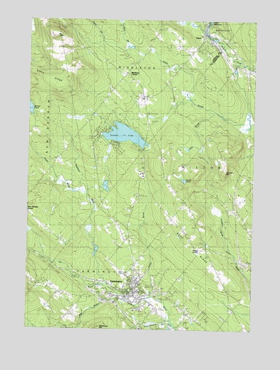
Farmington, NH USGS Topographic Map
Click on map above to begin viewing in our Map Viewer.

This topographic map contains these locations and features:
Feature Name Type Latitude Longitude GNIS ID View Map
Birch RidgeRidgeN43.4723°W71.1092°865598View Map
Branch River Dam Number 1DamN43.4934°W71.0195°1775831View Map
Branch River ReservoirReservoirN43.4926°W71.0220°1775832View Map
Currier DamDamN43.4334°W71.0812°1775840View Map
Currier PondReservoirN43.4329°W71.0812°1775841View Map
Dames BrookStreamN43.3873°W71.0534°866461View Map
Ela RiverStreamN43.3929°W71.0795°866771View Map
FarmingtonPopulated PlaceN43.3898°W71.0651°866840View Map
Farmington Census Designated PlaceCensusN43.3995°W71.0724°2378064View Map
Farmington Country ClubLocaleN43.3834°W71.0495°1914750View Map
Farmington Fire DepartmentBuildingN43.3887°W71.0642°2605073View Map
Farmington Pentecostal ChurchChurchN43.3887°W71.0603°1914751View Map
Farmington Police DepartmentBuildingN43.3912°W71.0647°2752967View Map
Farmington Post OfficePost OfficeN43.3883°W71.0656°1914752View Map
Farmington Senior High SchoolSchoolN43.3944°W71.0737°2499479View Map
Goodwin LibraryBuildingN43.3873°W71.0606°1914771View Map
Gould PondLakeN43.4353°W71.0379°867151View Map
Hart BrookStreamN43.4623°W71.0228°867392View Map
Hayes BrookStreamN43.4279°W71.0892°867416View Map
Hayes CemeteryCemeteryN43.4083°W71.0271°1914788View Map
Hayes CornerPopulated PlaceN43.4084°W71.0245°867418View Map
Henry Wilson Memorial SchoolSchoolN43.3928°W71.0707°1914790View Map
Horn BrookStreamN43.4873°W71.0681°867599View Map
Interchange 17CrossingN43.4026°W71.0053°1914809View Map
Interchange 18CrossingN43.4795°W71.0048°1914810View Map
Jones BrookStreamN43.4823°W71.0090°867803View Map
Lyman BrookStreamN43.4056°W71.0092°865180View Map
Mad RiverStreamN43.3873°W71.0673°868230View Map
Main Street SchoolSchoolN43.3870°W71.0623°1914830View Map
Memorial Drive SchoolSchoolN43.3923°W71.0703°868380View Map
Middleton CornersPopulated PlaceN43.4762°W71.0695°868423View Map
Middleton Fire and RescueBuildingN43.4787°W71.0709°2605309View Map
Middleton Police DepartmentBuildingN43.4784°W71.0702°2752830View Map
Mount JesseSummitN43.4909°W71.1073°867775View Map
New Durham CornerPopulated PlaceN43.4220°W71.1245°868704View Map
Nute RidgeRidgeN43.4067°W71.0292°868858View Map
Nute Ridge SchoolSchoolN43.3998°W71.0187°868859View Map
Nutes Ridge CemeteryCemeteryN43.4223°W71.0470°1914867View Map
Pokamoonshine BrookStreamN43.3787°W71.0451°869274View Map
Saint Peters SchoolSchoolN43.3876°W71.0748°869735View Map
Sunrise LakeReservoirN43.4536°W71.0716°870283View Map
Sunrise Lake DamDamN43.4523°W71.0809°1775311View Map
Teneriffe MountainSummitN43.4379°W71.0148°870357View Map
Therriaults LandingAirportN43.4818°W71.0588°2770547View Map
Town of MiddletonCivilN43.4832°W71.0685°873664View Map
Town of MiltonCivilN43.4493°W71.0075°873668View Map
UnionPopulated PlaceN43.4915°W71.0231°870569View Map
Union Census Designated PlaceCensusN43.4912°W71.0231°2629743View Map
Union Meadows DamDamN43.4984°W71.0262°1775152View Map
Union Post OfficePost OfficeN43.4895°W71.0203°1916141View Map
Valley View Community Elementary SchoolSchoolN43.3958°W71.0765°2499484View Map
Wakefield Fire and Rescue Station 3BuildingN43.4925°W71.0249°2605053View Map
Waldron Mill PondReservoirN43.4078°W71.0859°1914952View Map
Wentworth CemeteryCemeteryN43.4436°W71.0608°1914955View Map
Whitehouse CemeteryCemeteryN43.4677°W71.0606°870857View Map

Note: Coordinates in the location and feature list above are referenced to NAD83 datum.


Copyright (C) 2008-2024 Ryan Niemi / Sunset Dynamics ... All Rights Reserved