TopoQuest Logo
Do you find TopoQuest useful?
Help keep TopoQuest running and adding new maps/features by donating!
Bitcoin:  19c7KJd3qBynnjoSw5npx9KScwjBe4ifkT
Litecoin:  LXs6TkuXGGXo1vDsWCkWVdjQX94eUKd6ui
Home View Maps Find Maps Find Places Resources & Links


Farmington Falls, Maine Topographic Map

USGS Map Title: Farmington Falls, ME
USGS Map MRC: 44070E1
DRG (GeoTIFF) Download: o44070e1.tif


Neighboring USGS Topographic Map Quads:


  Farmington, ME  
44070F2
 

  New Sharon, ME  
44070F1
 

  Mercer, ME  
44069F8
 

  Wilton, ME  
44070E2
 

  Farmington Falls, ME  
44070E1
 

  Belgrade Lakes, ME  
44069E8
 

  Livermore Falls, ME  
44070D2
 

  Fayette, ME  
44070D1
 

  Readfield, ME  
44069D8


Map MRC Location:

N45°
W71°
N45°
W70°
H8 H7 H6 H5 H4 H3 H2 H1
G8 G7 G6 G5 G4 G3 G2 G1
F8 F7 F6 F5 F4 F3 F2 F1
E8 E7 E6 E5 E4 E3 E2 E1
D8 D7 D6 D5 D4 D3 D2 D1
C8 C7 C6 C5 C4 C3 C2 C1
B8 B7 B6 B5 B4 B3 B2 B1
A8 A7 A6 A5 A4 A3 A2 A1
N44°
W71°
N44°
W70°

Farmington Falls, ME USGS 1:24K Topographic Map Preview:
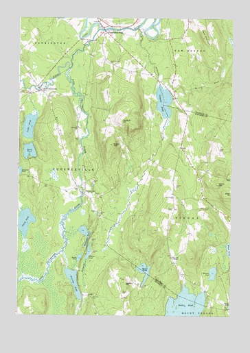
Farmington Falls, ME USGS Topographic Map
Click on map above to begin viewing in our Map Viewer.

This topographic map contains these locations and features:
Feature Name Type Latitude Longitude GNIS ID View Map
Blabon HillSummitN44.5718°W70.0697°562382View Map
Black PondLakeN44.5281°W70.0006°562499View Map
Cape Cod HillSummitN44.6168°W70.0161°563466View Map
Cape Cod Hill Elementary SchoolSchoolN44.6110°W70.0332°1908289View Map
Center CemeteryCemeteryN44.5534°W70.0891°563746View Map
Chapman CemeteryCemeteryN44.5176°W70.0284°2736695View Map
ChestervillePopulated PlaceN44.5512°W70.0862°563919View Map
Chesterville Hill CemeteryCemeteryN44.6059°W70.0719°563920View Map
Chesterville SchoolSchoolN44.5792°W70.0898°563921View Map
Chesterville Volunteer Fire StationBuildingN44.5781°W70.0900°2553116View Map
Chesterville Wildlife Management AreaParkN44.5398°W70.0973°1908297View Map
Crowell PondLakeN44.5901°W70.0397°564618View Map
Eaton MountainSummitN44.5512°W70.0001°565757View Map
Egypt PondLakeN44.5187°W70.0503°565816View Map
Farmington FallsPopulated PlaceN44.6209°W70.0753°566055View Map
Farmington Falls Fire DepartmentBuildingN44.6214°W70.0745°2552725View Map
Farmington Falls Post OfficePost OfficeN44.6211°W70.0758°1908324View Map
Farmington Falls Union Baptist ChurchChurchN44.6237°W70.0770°1908325View Map
Fellows PondLakeN44.5264°W70.0833°566092View Map
Franklin CemeteryCemeteryN44.5545°W70.0328°566534View Map
Horseshoe PondLakeN44.5346°W70.0855°568315View Map
Little Norridgewock StreamStreamN44.6037°W70.0953°569939View Map
Little Norridgewock Stream ReservoirReservoirN44.5510°W70.0869°1773732View Map
Locke PondLakeN44.5793°W70.1186°570148View Map
Lowell CemeteryCemeteryN44.5742°W70.0889°570461View Map
McGurdy StreamStreamN44.6206°W70.0545°570989View Map
Mercer DamDamN44.5510°W70.0869°1773731View Map
Norcross CemeteryCemeteryN44.5076°W70.0807°572226View Map
Norcross PondLakeN44.5143°W70.0918°572229View Map
North ChestervillePopulated PlaceN44.5945°W70.1120°572322View Map
North PondLakeN44.5392°W70.1207°572393View Map
North Vienna ChurchChurchN44.5498°W70.0339°572422View Map
Old Bluff HillSummitN44.5820°W70.0645°572685View Map
Robinson PondLakeN44.5606°W70.1248°574332View Map
Round PondLakeN44.5242°W70.0885°574504View Map
Sanborn HillSummitN44.5140°W70.0617°574814View Map
Sand PondLakeN44.5688°W70.1185°574856View Map
Seaveys CornerPopulated PlaceN44.5248°W70.0337°579682View Map
Seaveys Corner CemeteryCemeteryN44.5254°W70.0349°2736768View Map
Soper CemeteryCemeteryN44.5098°W70.0634°575729View Map
Sugar BrookStreamN44.5437°W70.1226°576493View Map
Town of ChestervilleCivilN44.5493°W70.0918°582409View Map
Town of ViennaCivilN44.5474°W70.0030°582781View Map
Vienna MountainSummitN44.5556°W70.0076°577719View Map
Webster CemeteryCemeteryN44.5929°W70.1235°577955View Map
Whittier BrookStreamN44.5951°W70.0401°578437View Map
Whittier PondLakeN44.5181°W70.0101°578440View Map
Wilson StreamStreamN44.6203°W70.0778°578558View Map
York HillSummitN44.5701°W70.0076°578776View Map
Zion HillSummitN44.5778°W70.1017°578818View Map
Zion Hill CemeteryCemeteryN44.5920°W70.1081°578819View Map

Note: Coordinates in the location and feature list above are referenced to NAD83 datum.


Copyright (C) 2008-2024 Ryan Niemi / Sunset Dynamics ... All Rights Reserved