TopoQuest Logo
Do you find TopoQuest useful?
Help keep TopoQuest running and adding new maps/features by donating!
Bitcoin:  19c7KJd3qBynnjoSw5npx9KScwjBe4ifkT
Litecoin:  LXs6TkuXGGXo1vDsWCkWVdjQX94eUKd6ui
Home View Maps Find Maps Find Places Resources & Links


Farson, Iowa Topographic Map

USGS Map Title: Farson, IA
USGS Map MRC: 41092A3
DRG (GeoTIFF) Download: o41092a3.tif


Neighboring USGS Topographic Map Quads:


  Fremont, IA  
41092B4
 

  Hedrick, IA  
41092B3
 

  Pekin, IA  
41092B2
 

  Ottumwa North, IA  
41092A4
 

  Farson, IA  
41092A3
 

  Abingdon, IA  
41092A2
 

  Ottumwa South, IA  
40092H4
 

  Agency, IA  
40092H3
 

  Eldon, IA  
40092H2


Map MRC Location:

N42°
W93°
N42°
W92°
H8 H7 H6 H5 H4 H3 H2 H1
G8 G7 G6 G5 G4 G3 G2 G1
F8 F7 F6 F5 F4 F3 F2 F1
E8 E7 E6 E5 E4 E3 E2 E1
D8 D7 D6 D5 D4 D3 D2 D1
C8 C7 C6 C5 C4 C3 C2 C1
B8 B7 B6 B5 B4 B3 B2 B1
A8 A7 A6 A5 A4 A3 A2 A1
N41°
W93°
N41°
W92°

Farson, IA USGS 1:24K Topographic Map Preview:
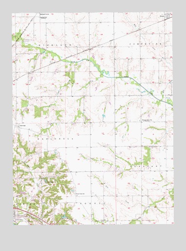
Farson, IA USGS Topographic Map
Click on map above to begin viewing in our Map Viewer.

This topographic map contains these locations and features:
Feature Name Type Latitude Longitude GNIS ID View Map
Bladensburg CemeteryCemeteryN41.0456°W92.2689°454671View Map
Brumsey CemeteryCemeteryN41.0097°W92.2668°1975605View Map
Coon CreekStreamN41.0103°W92.2699°455597View Map
Crossroads SchoolSchoolN41.0164°W92.3046°465638View Map
DahlonegaPopulated PlaceN41.0586°W92.3699°455767View Map
Dahlonega CemeteryCemeteryN41.0540°W92.3702°1975620View Map
Dahlonega Post Office (historical)Post OfficeN41.0586°W92.3699°1975402View Map
FarsonLocaleN41.1208°W92.2546°1975400View Map
FarsonPopulated PlaceN41.1222°W92.2552°456559View Map
Farson Post Office (historical)Post OfficeN41.1222°W92.2552°1975401View Map
Garrison Rock CemeteryCemeteryN41.0667°W92.3446°1975603View Map
Highland SchoolLocaleN41.1225°W92.3538°457484View Map
Jonathan Woody Historical MarkerParkN41.0539°W92.3699°1975597View Map
Kitterman CemeteryCemeteryN41.0417°W92.3446°1975618View Map
Little Cedar CreekStreamN41.0956°W92.3294°458452View Map
Loch BurnsPopulated PlaceN41.0256°W92.3502°458547View Map
McCormick CemeteryCemeteryN41.1092°W92.3650°458897View Map
Nasby Corner CemeteryCemeteryN41.0833°W92.3419°1975617View Map
Nasby SchoolSchoolN41.0761°W92.2960°459434View Map
Pleasant Grove SchoolLocaleN41.0606°W92.2732°460233View Map
Round Point CemeteryCemeteryN41.0188°W92.3270°1975619View Map
Round Point SchoolSchoolN41.0183°W92.3268°460830View Map
Sterner CemeteryCemeteryN41.0126°W92.2501°461989View Map
Sugar CreekStreamN41.0186°W92.3574°462060View Map
Township of DahlonegaCivilN41.0535°W92.3433°467671View Map
Township of HighlandCivilN41.1189°W92.3529°468041View Map
Tunis Post Office (historical)Post OfficeN41.0172°W92.2960°1975391View Map
Wapello County Grain Incorporated ElevatorLocaleN41.0556°W92.2960°1975424View Map
Wolf CreekStreamN41.0728°W92.2588°463165View Map

Note: Coordinates in the location and feature list above are referenced to NAD83 datum.


Copyright (C) 2008-2025 Ryan Niemi / Sunset Dynamics ... All Rights Reserved