TopoQuest Logo
Do you find TopoQuest useful?
Help keep TopoQuest running and adding new maps/features by donating!
Bitcoin:  19c7KJd3qBynnjoSw5npx9KScwjBe4ifkT
Litecoin:  LXs6TkuXGGXo1vDsWCkWVdjQX94eUKd6ui
Home View Maps Find Maps Find Places Resources & Links


Ottumwa South, Iowa Topographic Map

USGS Map Title: Ottumwa South, IA
USGS Map MRC: 40092H4
DRG (GeoTIFF) Download: o40092h4.tif


Neighboring USGS Topographic Map Quads:


  Chillicothe, IA  
41092A5
 

  Ottumwa North, IA  
41092A4
 

  Farson, IA  
41092A3
 

  Blakesburg NE, IA  
40092H5
 

  Ottumwa South, IA  
40092H4
 

  Agency, IA  
40092H3
 

  Paris, IA  
40092G5
 

  Bloomfield North, IA  
40092G4
 

  Floris, IA  
40092G3


Map MRC Location:

N41°
W93°
N41°
W92°
H8 H7 H6 H5 H4 H3 H2 H1
G8 G7 G6 G5 G4 G3 G2 G1
F8 F7 F6 F5 F4 F3 F2 F1
E8 E7 E6 E5 E4 E3 E2 E1
D8 D7 D6 D5 D4 D3 D2 D1
C8 C7 C6 C5 C4 C3 C2 C1
B8 B7 B6 B5 B4 B3 B2 B1
A8 A7 A6 A5 A4 A3 A2 A1
N40°
W93°
N40°
W92°

Ottumwa South, IA USGS 1:24K Topographic Map Preview:
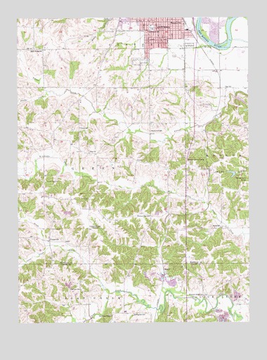
Ottumwa South, IA USGS Topographic Map
Click on map above to begin viewing in our Map Viewer.

This topographic map contains these locations and features:
Feature Name Type Latitude Longitude GNIS ID View Map
Agassiz Elementary SchoolSchoolN40.9979°W92.4166°454104View Map
Airpower MuseumBuildingN40.9878°W92.4841°1975427View Map
Airpower Museum LibraryBuildingN40.9878°W92.4841°1975426View Map
American Little League FieldParkN40.9986°W92.4374°1975428View Map
Bible Baptist ChurchChurchN40.9981°W92.4349°1975442View Map
Browns Mills Post Office (historical)Post OfficeN40.8792°W92.4585°1976025View Map
Brush CreekStreamN40.8872°W92.4513°454885View Map
CarbonPopulated PlaceN40.8964°W92.4219°464490View Map
Carbon (historical)LocaleN40.8964°W92.4219°1976021View Map
Carbon Hill Post Office (historical)Post OfficeN40.8972°W92.4219°1976022View Map
Carbon Post Office (historical)Post OfficeN40.8964°W92.4219°1976024View Map
Church of the BrethrenChurchN40.9981°W92.4396°1975444View Map
Coon CreekStreamN40.9067°W92.4838°455610View Map
County Farm Number One CemeteryCemeteryN40.9917°W92.4752°1975604View Map
Dexter Baby GraveCemeteryN40.9333°W92.4168°1975609View Map
Douma Elementary SchoolSchoolN40.9953°W92.4270°1975538View Map
Dove Ministries ChurchChurchN40.9806°W92.4285°1975515View Map
Evangelistic TempleChurchN40.9911°W92.4163°1975513View Map
Fairview SchoolSchoolN40.8889°W92.4666°456515View Map
Forest Lake CampLocaleN40.9345°W92.3824°456674View Map
Golden Arrow Mobile ParkPopulated PlaceN40.9931°W92.4035°1975448View Map
Gray Eagle Wildlife ReserveParkN40.9958°W92.3932°1975384View Map
Hazel Dell SchoolSchoolN40.9536°W92.4288°457359View Map
Hickory Flat SchoolSchoolN40.9189°W92.4291°457432View Map
Hickory Grove CampLocaleN40.9411°W92.4082°457433View Map
High Point SchoolSchoolN40.9875°W92.4866°457450View Map
Horan SchoolSchoolN40.9136°W92.3910°457660View Map
Jefferson ParkParkN40.9903°W92.4155°1975646View Map
Jefferson SchoolSchoolN40.9945°W92.4299°457931View Map
Jehovahs WitnessesChurchN40.9981°W92.4107°1975445View Map
Jesus is the Answer FellowshipChurchN40.9928°W92.4174°1975440View Map
KOIA-TV (Ottumwa)TowerN40.9639°W92.3974°467366View Map
Liberty SchoolSchoolN40.9361°W92.3944°458328View Map
Livingston SchoolSchoolN40.8786°W92.4380°458539View Map
McIntire CemeteryCemeteryN40.9645°W92.4006°458918View Map
Midwest Therapeutic ClinicHospitalN40.9950°W92.4460°1975450View Map
Ogg SchoolSchoolN40.9711°W92.3877°459809View Map
OrmanvillePopulated PlaceN40.9086°W92.4832°464684View Map
Ormanville CemeteryCemeteryN40.9134°W92.4823°459901View Map
Ormanville Post Office (historical)Post OfficeN40.9086°W92.4832°1975394View Map
Ottumwa Baptist TempleChurchN40.9981°W92.4269°1975441View Map
Pickwick Church of ChristChurchN40.9981°W92.4374°1975443View Map
Pickwick Elementary SchoolSchoolN40.9982°W92.4415°1975539View Map
Pickwick ParkParkN40.9970°W92.4285°1975647View Map
Pioneer Ridge Nature Area and Nature CenterParkN40.9084°W92.4002°1975429View Map
Pleasant Ridge CemeteryCemeteryN40.9330°W92.4855°460283View Map
Pleasant Ridge SchoolSchoolN40.8859°W92.3999°460288View Map
Plymouth Brethren Bible ChapelChurchN40.9992°W92.4338°1975512View Map
Point Isabel CemeteryCemeteryN40.9258°W92.4616°460345View Map
Point Isabelle Post Office (historical)Post OfficeN40.9222°W92.4621°1975393View Map
Rater Post Office (historical)Post OfficeN40.8964°W92.4224°1976020View Map
Rime CemeteryCemeteryN40.8900°W92.4284°460637View Map
Sandy CreekStreamN40.9706°W92.4721°461417View Map
Shaul CemeteryCemeteryN40.9955°W92.4501°461542View Map
Sherman ChapelChurchN40.8778°W92.4496°461571View Map
Sherman Chapel CemeteryCemeteryN40.8784°W92.4515°1976140View Map
Spence CemeteryCemeteryN40.8917°W92.3766°1976144View Map
Township of GreenCivilN40.9354°W92.4672°467966View Map
Trinity Lutheran ChurchChurchN40.9978°W92.4460°1975438View Map
Union SchoolSchoolN40.9547°W92.4671°462465View Map
Valley Village Mobile Home ParkPopulated PlaceN40.9861°W92.3794°1975531View Map
Wilkenson GraveCemeteryN40.9528°W92.4418°1975610View Map
Zion CemeteryCemeteryN40.9449°W92.4615°1975611View Map
Zion ChurchChurchN40.9450°W92.4621°463268View Map
Zion Community Church of GodChurchN40.9820°W92.4385°1975434View Map

Note: Coordinates in the location and feature list above are referenced to NAD83 datum.


Copyright (C) 2008-2025 Ryan Niemi / Sunset Dynamics ... All Rights Reserved