TopoQuest Logo
Do you find TopoQuest useful?
Help keep TopoQuest running and adding new maps/features by donating!
Bitcoin:  19c7KJd3qBynnjoSw5npx9KScwjBe4ifkT
Litecoin:  LXs6TkuXGGXo1vDsWCkWVdjQX94eUKd6ui
Home View Maps Find Maps Find Places Resources & Links


Fawnskin, California Topographic Map

USGS Map Title: Fawnskin, CA
USGS Map MRC: 34116C8
DRG (GeoTIFF) Download: o34116c8.tif


Neighboring USGS Topographic Map Quads:


  Fifteenmile Valley, CA  
34117D1
 

  Lucerne Valley, CA  
34116D8
 

  Cougar Buttes, CA  
34116D7
 

  Butler Peak, CA  
34117C1
 

  Fawnskin, CA  
34116C8
 

  Big Bear City, CA  
34116C7
 

  Keller Peak, CA  
34117B1
 

  Big Bear Lake, CA  
34116B8
 

  Moonridge, CA  
34116B7


Map MRC Location:

N35°
W117°
N35°
W116°
H8 H7 H6 H5 H4 H3 H2 H1
G8 G7 G6 G5 G4 G3 G2 G1
F8 F7 F6 F5 F4 F3 F2 F1
E8 E7 E6 E5 E4 E3 E2 E1
D8 D7 D6 D5 D4 D3 D2 D1
C8 C7 C6 C5 C4 C3 C2 C1
B8 B7 B6 B5 B4 B3 B2 B1
A8 A7 A6 A5 A4 A3 A2 A1
N34°
W117°
N34°
W116°

Fawnskin, CA USGS 1:24K Topographic Map Preview:
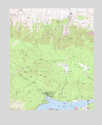
Fawnskin, CA USGS Topographic Map
Click on map above to begin viewing in our Map Viewer.

This topographic map contains these locations and features:
Feature Name Type Latitude Longitude GNIS ID View Map
Arctic CanyonValleyN34.3600°W116.8820°269569View Map
Arctic Canyon PitMineN34.3533°W116.8973°269570View Map
BellevilleLocaleN34.3011°W116.8842°269793View Map
Bertha PeakSummitN34.2831°W116.8992°269799View Map
Bertha RidgeRidgeN34.2817°W116.8861°269800View Map
Big Bear Ranger StationLocaleN34.2633°W116.9009°269808View Map
Big Bear Solar ObservatoryLocaleN34.2583°W116.9211°269809View Map
Bousic CanyonValleyN34.3661°W116.9114°269992View Map
Claudia QuarryMineN34.3167°W116.9522°2676079View Map
Cougar Crest TrailheadLocaleN34.2633°W116.9111°274969View Map
Crystal CreekStreamN34.3722°W116.9278°270696View Map
Delamar MountainSummitN34.2908°W116.9450°270828View Map
Delamar SpringSpringN34.2929°W116.9563°270829View Map
Dry CanyonValleyN34.3706°W116.9686°241628View Map
Eagle PointCapeN34.2533°W116.9039°270969View Map
East Boat RampLocaleN34.2611°W116.8875°1841827View Map
East Fork Dry CanyonValleyN34.3475°W116.9659°270990View Map
FawnskinPopulated PlaceN34.2681°W116.9425°271110View Map
Fawnskin Community ChurchChurchN34.2703°W116.9448°1841828View Map
Fawnskin Post OfficePost OfficeN34.2692°W116.9486°1841829View Map
Fawnskin ValleyBasinN34.2839°W116.9656°271111View Map
Furnace CanyonValleyN34.3625°W116.9223°271254View Map
Furnace SpringSpringN34.3586°W116.9285°271255View Map
Gilner PointCapeN34.2520°W116.9400°271300View Map
Grays CampsiteLocaleN34.2733°W116.9703°271418View Map
Grays LandingLocaleN34.2508°W116.9617°1841832View Map
Grays PeakSummitN34.2608°W116.9709°1656534View Map
Greenland Camp (historical)LocaleN34.3194°W116.9798°1667128View Map
Greenlead CreekStreamN34.3022°W116.9778°271437View Map
Greenlead MineMineN34.3169°W116.9748°271438View Map
Grout BayBayN34.2636°W116.9425°271452View Map
Grout Bay CampgroundLocaleN34.2622°W116.9467°274973View Map
Grout Bay Recreation AreaParkN34.2645°W116.9481°1841833View Map
Grout CreekStreamN34.2670°W116.9467°271453View Map
Hanna FlatFlatN34.2895°W116.9795°271486View Map
Hanna Flat CampgroundLocaleN34.2881°W116.9756°1841834View Map
Hanna RocksSummitN34.2717°W116.9895°1656538View Map
Harold F Whittle CampLocaleN34.2822°W116.9656°271498View Map
Harry SpringSpringN34.2927°W116.9840°271505View Map
Harvey K MineMineN34.3144°W116.9017°1667129View Map
Hitchcock RanchLocaleN34.3050°W116.9173°271585View Map
Hitchcock SpringSpringN34.3121°W116.9550°271586View Map
Holcomb ValleyValleyN34.3072°W116.9275°271603View Map
Holcomb Valley CampgroundLocaleN34.3028°W116.8973°274971View Map
Interlaken Shopping CenterLocaleN34.2528°W116.8850°1841835View Map
John Bull FlatFlatN34.3256°W116.8942°271796View Map
Juniper PointCapeN34.2603°W116.9001°274972View Map
Juniper Point MarinaLocaleN34.2603°W116.9009°1841838View Map
Lagonita PointCapeN34.2506°W116.9320°1841839View Map
Lakeview Shopping CenterLocaleN34.2533°W116.8842°1841843View Map
Lighthouse Trailer ResortLocaleN34.2611°W116.9128°1841846View Map
Little Bear PeakSummitN34.2911°W116.9703°272069View Map
Little Bear SpringSpringN34.2969°W116.9748°272071View Map
Marble Canyon QuarryMineN34.3453°W116.8806°2674824View Map
Meadows Edge Picnic AreaLocaleN34.2606°W116.9000°274968View Map
MinnelusaPopulated PlaceN34.2664°W116.8925°1667137View Map
Minnelusa CanyonValleyN34.2625°W116.8920°272494View Map
North Shore Elementary SchoolSchoolN34.2619°W116.8843°272717View Map
North Shore LandingLocaleN34.2522°W116.9600°1841850View Map
North Shore Recreation AreaParkN34.2645°W116.9314°1841851View Map
Old Baldy Council CampLocaleN34.2953°W116.9139°272780View Map
Poligue CanyonValleyN34.2603°W116.9214°273072View Map
Quail SpringSpringN34.3636°W116.9709°273148View Map
Rathbun CreekStreamN34.2547°W116.8903°273207View Map
San Bernardino County Fire Department Station 96 FawnskinBuildingN34.2698°W116.9471°2664561View Map
Sawmill Cove LandingLocaleN34.2506°W116.9378°1841857View Map
Serrano CampgroundLocaleN34.2611°W116.9156°1841859View Map
Shelter CoveBayN34.2611°W116.9442°1841860View Map
Upper Holcomb ValleyValleyN34.3036°W116.9067°274288View Map
West Fork Dry CanyonValleyN34.3475°W116.9659°274429View Map
West Public Boat RampLocaleN34.2578°W116.9517°1841865View Map
Wilbur GraveCemeteryN34.3058°W116.9003°274492View Map
Wild Rose CanyonValleyN34.3456°W116.9217°274496View Map
Windy PointCapeN34.2595°W116.9431°274553View Map
Woodland TrailheadLocaleN34.2631°W116.8886°274967View Map
Wright MineMineN34.3428°W116.9981°274578View Map

Note: Coordinates in the location and feature list above are referenced to NAD83 datum.


Copyright (C) 2008-2024 Ryan Niemi / Sunset Dynamics ... All Rights Reserved