TopoQuest Logo
Do you find TopoQuest useful?
Help keep TopoQuest running and adding new maps/features by donating!
Bitcoin:  19c7KJd3qBynnjoSw5npx9KScwjBe4ifkT
Litecoin:  LXs6TkuXGGXo1vDsWCkWVdjQX94eUKd6ui
Home View Maps Find Maps Find Places Resources & Links


Fenton, Louisiana Topographic Map

USGS Map Title: Fenton, LA
USGS Map MRC: 30092C8
DRG (GeoTIFF) Download: o30092c8.tif


Neighboring USGS Topographic Map Quads:


  Topsy, LA  
30093D1
 

  Indian Village, LA  
30092D8
 

  Kinder, LA  
30092D7
 

  Hecker, LA  
30093C1
 

  Fenton, LA  
30092C8
 

  Welsh North, LA  
30092C7
 

  Iowa, LA  
30093B1
 

  Lacassine, LA  
30092B8
 

  Welsh South, LA  
30092B7


Map MRC Location:

N31°
W93°
N31°
W92°
H8 H7 H6 H5 H4 H3 H2 H1
G8 G7 G6 G5 G4 G3 G2 G1
F8 F7 F6 F5 F4 F3 F2 F1
E8 E7 E6 E5 E4 E3 E2 E1
D8 D7 D6 D5 D4 D3 D2 D1
C8 C7 C6 C5 C4 C3 C2 C1
B8 B7 B6 B5 B4 B3 B2 B1
A8 A7 A6 A5 A4 A3 A2 A1
N30°
W93°
N30°
W92°

Fenton, LA USGS 1:24K Topographic Map Preview:
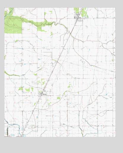
Fenton, LA USGS Topographic Map
Click on map above to begin viewing in our Map Viewer.

This topographic map contains these locations and features:
Feature Name Type Latitude Longitude GNIS ID View Map
FentonPopulated PlaceN30.3671°W92.9182°534930View Map
Fenton Baptist ChurchChurchN30.3669°W92.9174°2601702View Map
Fenton Elementary Junior High SchoolSchoolN30.3664°W92.9210°545828View Map
Fenton Gas FieldOilfieldN30.3696°W92.9251°545827View Map
Fenton Post OfficePost OfficeN30.3640°W92.9171°1630362View Map
Greater Saint Joseph Baptist ChurchChurchN30.3690°W92.9188°2601864View Map
Jefferson Davis Parish Fire District 5BuildingN30.3654°W92.9181°2691831View Map
Lacassine Gas FieldOilfieldN30.2608°W92.9407°545855View Map
Little BayouStreamN30.3663°W92.9990°536480View Map
Lonesome Dove AirfieldAirportN30.2856°W92.9404°2676748View Map
Parish Governing Authority District 10CivilN30.3665°W92.9334°1929783View Map
Pine Hill CemeteryCemeteryN30.2602°W92.9635°538179View Map
Saint Charles Borromeo Catholic ChurchChurchN30.3656°W92.9202°2602616View Map
Village of FentonCivilN30.3638°W92.9164°2407452View Map
WoodlawnPopulated PlaceN30.2930°W92.9585°540520View Map
Woodlawn Baptist ChurchChurchN30.2932°W92.9600°2602987View Map
Woodlawn Oil and Gas FieldOilfieldN30.2874°W92.9296°540527View Map
Woodlawn Oil FieldOilfieldN30.3280°W92.9426°545890View Map
Woodlawn Volunteer Fire DepartmentBuildingN30.2898°W92.9607°2691706View Map

Note: Coordinates in the location and feature list above are referenced to NAD83 datum.


Copyright (C) 2008-2025 Ryan Niemi / Sunset Dynamics ... All Rights Reserved