TopoQuest Logo
Do you find TopoQuest useful?
Help keep TopoQuest running and adding new maps/features by donating!
Bitcoin:  19c7KJd3qBynnjoSw5npx9KScwjBe4ifkT
Litecoin:  LXs6TkuXGGXo1vDsWCkWVdjQX94eUKd6ui
Home View Maps Find Maps Find Places Resources & Links


Lacassine, Louisiana Topographic Map

USGS Map Title: Lacassine, LA
USGS Map MRC: 30092B8
DRG (GeoTIFF) Download: o30092b8.tif


Neighboring USGS Topographic Map Quads:


  Hecker, LA  
30093C1
 

  Fenton, LA  
30092C8
 

  Welsh North, LA  
30092C7
 

  Iowa, LA  
30093B1
 

  Lacassine, LA  
30092B8
 

  Welsh South, LA  
30092B7
 

  Lake Charles SE, LA  
30093A1
 

  Hayes, LA  
30092A8
 

  Thornwell, LA  
30092A7


Map MRC Location:

N31°
W93°
N31°
W92°
H8 H7 H6 H5 H4 H3 H2 H1
G8 G7 G6 G5 G4 G3 G2 G1
F8 F7 F6 F5 F4 F3 F2 F1
E8 E7 E6 E5 E4 E3 E2 E1
D8 D7 D6 D5 D4 D3 D2 D1
C8 C7 C6 C5 C4 C3 C2 C1
B8 B7 B6 B5 B4 B3 B2 B1
A8 A7 A6 A5 A4 A3 A2 A1
N30°
W93°
N30°
W92°

Lacassine, LA USGS 1:24K Topographic Map Preview:
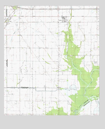
Lacassine, LA USGS Topographic Map
Click on map above to begin viewing in our Map Viewer.

This topographic map contains these locations and features:
Feature Name Type Latitude Longitude GNIS ID View Map
Bayou CheneStreamN30.1444°W92.8904°532508View Map
Bon Air Oil FieldOilfieldN30.1747°W92.9757°553747View Map
Broussard CemeteryCemeteryN30.1821°W92.9126°533432View Map
East Bayou LacassineStreamN30.1591°W92.8904°534697View Map
East Bell City Gas FieldOilfieldN30.1413°W92.9627°551262View Map
Foremans HallPopulated PlaceN30.1863°W92.9293°541093View Map
Gotreaux StripAirportN30.2128°W92.9336°2770512View Map
Interchange 44CrossingN30.2488°W92.9838°541382View Map
Interchange 48CrossingN30.2466°W92.9290°541383View Map
LacassinePopulated PlaceN30.2355°W92.9215°554960View Map
Lacassine Census Designated PlaceCensusN30.2331°W92.9208°2586689View Map
Lacassine High SchoolSchoolN30.2354°W92.9213°545856View Map
Lacassine Post OfficePost OfficeN30.2349°W92.9229°1630366View Map
Lacassine Volunteer Fire DepartmentBuildingN30.2351°W92.9180°2691869View Map
Lambert Chapel Christian Methodist Episcopal ChurchChurchN30.1587°W92.9291°2602165View Map
Light Plane Flyers AirfieldAirportN30.2495°W92.9716°2676800View Map
Lorrain CemeteryCemeteryN30.1399°W92.9121°536735View Map
North Hayes Gas FieldOilfieldN30.1352°W92.9502°537733View Map
Northeast Bon Air Gas FieldOilfieldN30.2335°W92.9490°545863View Map
O'Brien Flying ServiceAirportN30.2275°W92.9978°1632770View Map
Parish Governing Authority District 13CivilN30.1579°W92.9024°1929842View Map
Saint John Catholic ChurchChurchN30.2341°W92.9180°2602650View Map
South Iowa Oil FieldOilfieldN30.2024°W92.9963°551365View Map
Southeast Iowa Gas FieldOilfieldN30.2302°W92.9813°545878View Map
VerretPopulated PlaceN30.1566°W92.9290°540152View Map
Ward EightCivilN30.2355°W92.9379°545086View Map
West Bayou LacassineStreamN30.1594°W92.8910°540300View Map

Note: Coordinates in the location and feature list above are referenced to NAD83 datum.


Copyright (C) 2008-2025 Ryan Niemi / Sunset Dynamics ... All Rights Reserved