TopoQuest Logo
Do you find TopoQuest useful?
Help keep TopoQuest running and adding new maps/features by donating!
Bitcoin:  19c7KJd3qBynnjoSw5npx9KScwjBe4ifkT
Litecoin:  LXs6TkuXGGXo1vDsWCkWVdjQX94eUKd6ui
Home View Maps Find Maps Find Places Resources & Links


Fife Lake, Michigan Topographic Map

USGS Map Title: Fife Lake, MI
USGS Map MRC: 44085E3
DRG (GeoTIFF) Download: o44085e3.tif


Neighboring USGS Topographic Map Quads:


  Jacks Landing, MI  
44085F4
 

  South Boardman, MI  
44085F3
 

  Kalkaska, MI  
44085F2
 

  Walton, MI  
44085E4
 

  Fife Lake, MI  
44085E3
 

  Smithville, MI  
44085E2


Map MRC Location:

N45°
W86°
N45°
W85°
H8 H7 H6 H5 H4 H3 H2 H1
G8 G7 G6 G5 G4 G3 G2 G1
F8 F7 F6 F5 F4 F3 F2 F1
E8 E7 E6 E5 E4 E3 E2 E1
D8 D7 D6 D5 D4 D3 D2 D1
C8 C7 C6 C5 C4 C3 C2 C1
B8 B7 B6 B5 B4 B3 B2 B1
A8 A7 A6 A5 A4 A3 A2 A1
N44°
W86°
N44°
W85°

Fife Lake, MI USGS 1:24K Topographic Map Preview:
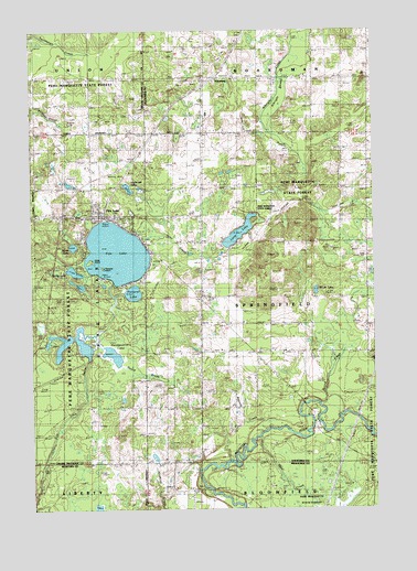
Fife Lake, MI USGS Topographic Map
Click on map above to begin viewing in our Map Viewer.

This topographic map contains these locations and features:
Feature Name Type Latitude Longitude GNIS ID View Map
Albright SwampSwampN44.6120°W85.2809°619910View Map
Bloom LakeLakeN44.5568°W85.2713°621610View Map
Bourne CreekStreamN44.5206°W85.2889°621779View Map
Cedar Creek SchoolSchoolN44.6125°W85.3542°622909View Map
Clark CemeteryCemeteryN44.5550°W85.3139°2494761View Map
Fife LakeLakeN44.5668°W85.3440°625936View Map
Fife LakePopulated PlaceN44.5769°W85.3506°625937View Map
Fife Lake Area Emergency Medical ServicesBuildingN44.5764°W85.3520°2661974View Map
Fife Lake Area Historical MuseumBuildingN44.5764°W85.3497°2496163View Map
Fife Lake Area ParkParkN44.5750°W85.3403°2496167View Map
Fife Lake Baptist ChurchChurchN44.5778°W85.3428°2496166View Map
Fife Lake CemeteryCemeteryN44.5778°W85.3550°2496210View Map
Fife Lake City ParkParkN44.5758°W85.3483°2496168View Map
Fife Lake Elementary SchoolSchoolN44.5764°W85.3561°2496161View Map
Fife Lake Medical ClinicHospitalN44.5767°W85.3500°2496162View Map
Fife Lake Post OfficePost OfficeN44.5772°W85.3483°2496160View Map
Fife Lake StationLocaleN44.5761°W85.3486°2496081View Map
Fife Lake Union District Number One Schoolhouse Historical MarkerParkN44.6125°W85.3533°2496194View Map
Fife Lake United Methodist ChurchChurchN44.5786°W85.3519°2496165View Map
Florence IslandIslandN44.5631°W85.3495°626188View Map
Forest Area High SchoolSchoolN44.6033°W85.3106°2494771View Map
Gould CreekStreamN44.5372°W85.3428°627020View Map
Ham CreekStreamN44.5186°W85.2920°627668View Map
Headquarters LakeLakeN44.5404°W85.3456°628026View Map
Helen IslandIslandN44.5650°W85.3534°628059View Map
Holbrook LakeLakeN44.5839°W85.3394°628406View Map
HousemanPopulated PlaceN44.6131°W85.3084°1617629View Map
Inlet CreekStreamN44.5703°W85.3351°629045View Map
Long LakeLakeN44.5722°W85.2990°630942View Map
Maple Hill SchoolSchoolN44.5258°W85.3134°631471View Map
Mirror LakeLakeN44.5687°W85.3598°632482View Map
Pickerel LakeLakeN44.5565°W85.3380°634789View Map
Saint Aloysius Catholic ChurchChurchN44.5772°W85.3442°2496164View Map
Saint Aloysius CemeteryCemeteryN44.5778°W85.3444°2496211View Map
Spring CreekStreamN44.5270°W85.2703°638553View Map
Spring LakeLakeN44.5622°W85.3596°638587View Map
Spring Lake CampgroundLocaleN44.5625°W85.3625°2496169View Map
Springfield ChurchChurchN44.5542°W85.3126°638624View Map
Stampfler SchoolSchoolN44.5114°W85.3242°638707View Map
Tannehill AirfieldAirportN44.5919°W85.3088°2650924View Map
Township of SpringfieldCivilN44.5549°W85.2729°1627109View Map
Village of Fife LakeCivilN44.5731°W85.3511°2398875View Map
Weaver SchoolSchoolN44.5836°W85.3131°1615927View Map

Note: Coordinates in the location and feature list above are referenced to NAD83 datum.


Copyright (C) 2008-2025 Ryan Niemi / Sunset Dynamics ... All Rights Reserved