TopoQuest Logo
Do you find TopoQuest useful?
Help keep TopoQuest running and adding new maps/features by donating!
Bitcoin:  19c7KJd3qBynnjoSw5npx9KScwjBe4ifkT
Litecoin:  LXs6TkuXGGXo1vDsWCkWVdjQX94eUKd6ui
Home View Maps Find Maps Find Places Resources & Links


Fiftone, Florida Topographic Map

USGS Map Title: Fiftone, FL
USGS Map MRC: 30081B8
DRG (GeoTIFF) Download: o30081b8.tif


Neighboring USGS Topographic Map Quads:


  Macclenny East, FL  
30082C1
 

  Baldwin, FL  
30081C8
 

  Marietta, FL  
30081C7
 

  Maxville, FL  
30082B1
 

  Fiftone, FL  
30081B8
 

  Jacksonville Heights, FL  
30081B7
 

  Lawtey, FL  
30082A1
 

  Middleburg SW, FL  
30081A8
 

  Middleburg, FL  
30081A7


Map MRC Location:

N31°
W82°
N31°
W81°
H8 H7 H6 H5 H4 H3 H2 H1
G8 G7 G6 G5 G4 G3 G2 G1
F8 F7 F6 F5 F4 F3 F2 F1
E8 E7 E6 E5 E4 E3 E2 E1
D8 D7 D6 D5 D4 D3 D2 D1
C8 C7 C6 C5 C4 C3 C2 C1
B8 B7 B6 B5 B4 B3 B2 B1
A8 A7 A6 A5 A4 A3 A2 A1
N30°
W82°
N30°
W81°

Fiftone, FL USGS 1:24K Topographic Map Preview:
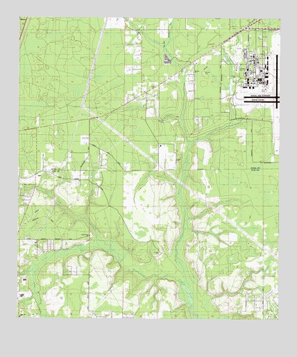
Fiftone, FL USGS Topographic Map
Click on map above to begin viewing in our Map Viewer.

This topographic map contains these locations and features:
Feature Name Type Latitude Longitude GNIS ID View Map
Big BranchStreamN30.1658°W81.9201°278636View Map
Caldwell BranchStreamN30.2383°W81.9301°279822View Map
Camp BranchStreamN30.1669°W81.9676°279871View Map
Cecil AirportAirportN30.2209°W81.8881°2676735View Map
Deese CemeteryCemeteryN30.1922°W81.9254°304964View Map
FiftonePopulated PlaceN30.2491°W81.9959°294409View Map
Fretwell ParkParkN30.2236°W81.8959°304959View Map
Gum BranchStreamN30.1472°W81.9901°283524View Map
Jacksonville Fire and Rescue Department Station 56BuildingN30.2208°W81.8816°2644237View Map
Lake FretwellReservoirN30.2214°W81.8983°304961View Map
Lake NewmanReservoirN30.2337°W81.9015°304962View Map
Long BranchStreamN30.1552°W81.9609°285969View Map
Long Branch CemeteryCemeteryN30.1597°W81.9648°304956View Map
Long Branch ChurchChurchN30.1597°W81.9651°285975View Map
Manning CemeteryCemeteryN30.2072°W81.9298°304963View Map
Mill BranchStreamN30.1622°W81.9198°286853View Map
Mill BranchStreamN30.1352°W81.9907°286859View Map
Moore BranchStreamN30.2077°W81.9212°287097View Map
Mount Zion ChurchChurchN30.2289°W81.9170°304960View Map
POW/MIA Memorial ParkParkN30.2300°W81.8909°304957View Map
Rowell CreekStreamN30.2061°W81.8979°290018View Map
Sal Taylor CreekStreamN30.1977°W81.9170°290412View Map
Wheeler BranchStreamN30.1336°W81.9076°293175View Map
Whitker CemeteryCemeteryN30.2272°W81.9093°304958View Map
Yellow Water CreekStreamN30.1380°W81.9182°293588View Map

Note: Coordinates in the location and feature list above are referenced to NAD83 datum.


Copyright (C) 2008-2024 Ryan Niemi / Sunset Dynamics ... All Rights Reserved