TopoQuest Logo
Do you find TopoQuest useful?
Help keep TopoQuest running and adding new maps/features by donating!
Bitcoin:  19c7KJd3qBynnjoSw5npx9KScwjBe4ifkT
Litecoin:  LXs6TkuXGGXo1vDsWCkWVdjQX94eUKd6ui
Home View Maps Find Maps Find Places Resources & Links


Middleburg SW, Florida Topographic Map

USGS Map Title: Middleburg SW, FL
USGS Map MRC: 30081A8
DRG (GeoTIFF) Download: o30081a8.tif


Neighboring USGS Topographic Map Quads:


  Maxville, FL  
30082B1
 

  Fiftone, FL  
30081B8
 

  Jacksonville Heights, FL  
30081B7
 

  Lawtey, FL  
30082A1
 

  Middleburg SW, FL  
30081A8
 

  Middleburg, FL  
30081A7
 

  Starke, FL  
29082H1
 

  Kingsley, FL  
29081H8
 

  Penney Farms, FL  
29081H7


Map MRC Location:

N31°
W82°
N31°
W81°
H8 H7 H6 H5 H4 H3 H2 H1
G8 G7 G6 G5 G4 G3 G2 G1
F8 F7 F6 F5 F4 F3 F2 F1
E8 E7 E6 E5 E4 E3 E2 E1
D8 D7 D6 D5 D4 D3 D2 D1
C8 C7 C6 C5 C4 C3 C2 C1
B8 B7 B6 B5 B4 B3 B2 B1
A8 A7 A6 A5 A4 A3 A2 A1
N30°
W82°
N30°
W81°

Middleburg SW, FL USGS 1:24K Topographic Map Preview:
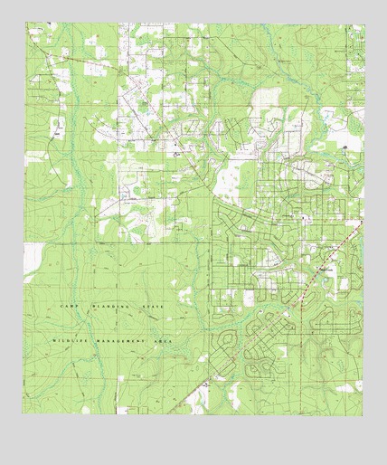
Middleburg SW, FL USGS Topographic Map
Click on map above to begin viewing in our Map Viewer.

This topographic map contains these locations and features:
Feature Name Type Latitude Longitude GNIS ID View Map
Big BranchStreamN30.1111°W81.9045°278635View Map
Boggy BranchStreamN30.0741°W81.9787°279156View Map
Bull CreekStreamN30.0380°W81.8887°279639View Map
Church of GodChurchN30.1144°W81.9898°307180View Map
Cinnamon Street ChurchChurchN30.0630°W81.9004°307182View Map
Clay County Fire Rescue Clay Hill Station 13BuildingN30.0998°W81.9548°2644087View Map
Clay Hill Church of GodChurchN30.0863°W81.9441°2449881View Map
Duckwater BranchStreamN30.0955°W81.9309°281842View Map
First Assembly of God ChurchChurchN30.0316°W81.9029°307186View Map
Fowler CemeteryCemeteryN30.0288°W81.9004°307190View Map
Freedom ChurchChurchN30.0855°W81.9407°307181View Map
Johns CemeteryCemeteryN30.1013°W81.8951°307188View Map
Middleburg Census Designated PlaceCensusN30.0502°W81.9011°2403285View Map
Middleburg Church of ChristChurchN30.0322°W81.9019°2449885View Map
Middleburg-Clay Hill DivisionCivilN30.1210°W81.9235°1935854View Map
Mill CreekStreamN30.0389°W81.8779°286868View Map
North Florida Christian AcademySchoolN30.0866°W81.9434°307191View Map
Oak Grove CemeteryCemeteryN30.0125°W81.9554°307189View Map
Oak Grove ChurchChurchN30.0111°W81.9320°287944View Map
Padget CemeteryCemeteryN30.1108°W81.9034°307187View Map
Saint Mark ChurchChurchN30.0541°W81.8879°307184View Map
Saint Mark Missionary Baptist ChurchChurchN30.0541°W81.8886°2449888View Map
Spencer's AirparkAirportN30.0649°W81.9633°309690View Map
The Church of Jesus Christ of Latter Day SaintsChurchN30.0635°W81.8972°307183View Map
The Jesus ChurchChurchN30.0494°W81.8898°307185View Map
Wilkinson Junior High SchoolSchoolN30.0831°W81.9443°307192View Map
Williams FieldAirportN30.0424°W81.8853°309691View Map

Note: Coordinates in the location and feature list above are referenced to NAD83 datum.


Copyright (C) 2008-2024 Ryan Niemi / Sunset Dynamics ... All Rights Reserved