TopoQuest Logo
Do you find TopoQuest useful?
Help keep TopoQuest running and adding new maps/features by donating!
Bitcoin:  19c7KJd3qBynnjoSw5npx9KScwjBe4ifkT
Litecoin:  LXs6TkuXGGXo1vDsWCkWVdjQX94eUKd6ui
Home View Maps Find Maps Find Places Resources & Links


Fitzgerald Hill, Arizona Topographic Map

USGS Map Title: Fitzgerald Hill, AZ
USGS Map MRC: 35112C4
DRG (GeoTIFF) Download: o35112c4.tif


Neighboring USGS Topographic Map Quads:


  Eagle Nest Mountain, AZ  
35112D5
 

  Stanford Tank, AZ  
35112D4
 

  Cataract Tank, AZ  
35112D3
 

  Horse Trap Mesa, AZ  
35112C5
 

  Fitzgerald Hill, AZ  
35112C4
 

  Hearst Mountain, AZ  
35112C3
 

  Cathedral Caves, AZ  
35112B5
 

  Ash Fork, AZ  
35112B4
 

  McLellan Reservoir, AZ  
35112B3


Map MRC Location:

N36°
W113°
N36°
W112°
H8 H7 H6 H5 H4 H3 H2 H1
G8 G7 G6 G5 G4 G3 G2 G1
F8 F7 F6 F5 F4 F3 F2 F1
E8 E7 E6 E5 E4 E3 E2 E1
D8 D7 D6 D5 D4 D3 D2 D1
C8 C7 C6 C5 C4 C3 C2 C1
B8 B7 B6 B5 B4 B3 B2 B1
A8 A7 A6 A5 A4 A3 A2 A1
N35°
W113°
N35°
W112°

Fitzgerald Hill, AZ USGS 1:24K Topographic Map Preview:
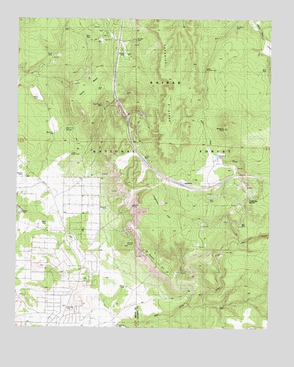
Fitzgerald Hill, AZ USGS Topographic Map
Click on map above to begin viewing in our Map Viewer.

This topographic map contains these locations and features:
Feature Name Type Latitude Longitude GNIS ID View Map
Antelope QuarriesLocaleN35.2833°W112.4449°43528View Map
Antelope SpringMineN35.2850°W112.4430°37612View Map
Antolini HillSummitN35.2806°W112.4368°25694View Map
Blue Cow TankReservoirN35.3285°W112.4826°40570View Map
Brown TankReservoirN35.2664°W112.4460°26792View Map
Buck TankReservoirN35.3546°W112.3777°26889View Map
Bunker TankReservoirN35.3609°W112.4478°27011View Map
Cedar TankReservoirN35.3190°W112.4380°27447View Map
Charcoal TankReservoirN35.2579°W112.4762°27511View Map
Cucamonga JunctionPopulated PlaceN35.3025°W112.3855°37733View Map
Daves TankReservoirN35.3430°W112.4911°40573View Map
Dog TankReservoirN35.2725°W112.3853°2091498View Map
Double A KnollSummitN35.3308°W112.3985°28547View Map
Double A Ranch (historical)LocaleN35.3172°W112.4013°28548View Map
Double A SidingLocaleN35.2908°W112.4213°37753View Map
Double A TankReservoirN35.3192°W112.4017°37754View Map
Dunbar TankReservoirN35.3667°W112.4452°40575View Map
Ferno MesaSummitN35.3470°W112.4643°28978View Map
Ferno Trick TankReservoirN35.3464°W112.4627°40572View Map
Fitzgerald HillSummitN35.3011°W112.4235°29033View Map
Garden TankReservoirN35.2963°W112.4995°29254View Map
Hazel TankReservoirN35.2922°W112.4855°29824View Map
Hop TankReservoirN35.3358°W112.4169°2091491View Map
Jim River TankReservoirN35.3720°W112.3938°30540View Map
Juan Tank CanyonValleyN35.2853°W112.3910°30632View Map
Kaibab Estates West Fire DepartmentBuildingN35.2799°W112.4716°2672422View Map
Lawson MineMineN35.3581°W112.4424°37895View Map
Lost TankReservoirN35.3022°W112.4058°31318View Map
Lower Cedar TankReservoirN35.3201°W112.4743°37916View Map
Murray TankReservoirN35.3111°W112.4979°32208View Map
Okie TankReservoirN35.3683°W112.4635°40571View Map
Paradise RidgeRidgeN35.3531°W112.4282°32676View Map
Punk TankReservoirN35.3605°W112.4841°38017View Map
Red TankReservoirN35.2919°W112.3898°33521View Map
Rock House TankReservoirN35.3401°W112.4593°40576View Map
Santa Cruz QuarryLocaleN35.2978°W112.4460°43527View Map
Santa Fe WellWellN35.2506°W112.4491°34072View Map
Shavel TankReservoirN35.3406°W112.3886°2091492View Map
Steiger TankReservoirN35.2586°W112.4000°34828View Map
Top TankReservoirN35.2517°W112.4186°2091499View Map
Twin TankReservoirN35.2520°W112.4666°35630View Map
Upper Jim River TankReservoirN35.3672°W112.4035°40574View Map
Westside TankReservoirN35.2982°W112.4561°36033View Map
Yellow Cow TankReservoirN35.3317°W112.4710°38199View Map
Yellow Cow TankReservoirN35.3301°W112.4771°45030View Map

Note: Coordinates in the location and feature list above are referenced to NAD83 datum.


Copyright (C) 2008-2024 Ryan Niemi / Sunset Dynamics ... All Rights Reserved