TopoQuest Logo
Do you find TopoQuest useful?
Help keep TopoQuest running and adding new maps/features by donating!
Bitcoin:  19c7KJd3qBynnjoSw5npx9KScwjBe4ifkT
Litecoin:  LXs6TkuXGGXo1vDsWCkWVdjQX94eUKd6ui
Home View Maps Find Maps Find Places Resources & Links


Stanford Tank, Arizona Topographic Map

USGS Map Title: Stanford Tank, AZ
USGS Map MRC: 35112D4
DRG (GeoTIFF) Download: o35112d4.tif


Neighboring USGS Topographic Map Quads:


  Howard Spring, AZ  
35112E5
 

  Red Hill Ranch, AZ  
35112E4
 

  Mixon Tank, AZ  
35112E3
 

  Eagle Nest Mountain, AZ  
35112D5
 

  Stanford Tank, AZ  
35112D4
 

  Cataract Tank, AZ  
35112D3
 

  Horse Trap Mesa, AZ  
35112C5
 

  Fitzgerald Hill, AZ  
35112C4
 

  Hearst Mountain, AZ  
35112C3


Map MRC Location:

N36°
W113°
N36°
W112°
H8 H7 H6 H5 H4 H3 H2 H1
G8 G7 G6 G5 G4 G3 G2 G1
F8 F7 F6 F5 F4 F3 F2 F1
E8 E7 E6 E5 E4 E3 E2 E1
D8 D7 D6 D5 D4 D3 D2 D1
C8 C7 C6 C5 C4 C3 C2 C1
B8 B7 B6 B5 B4 B3 B2 B1
A8 A7 A6 A5 A4 A3 A2 A1
N35°
W113°
N35°
W112°

Stanford Tank, AZ USGS 1:24K Topographic Map Preview:
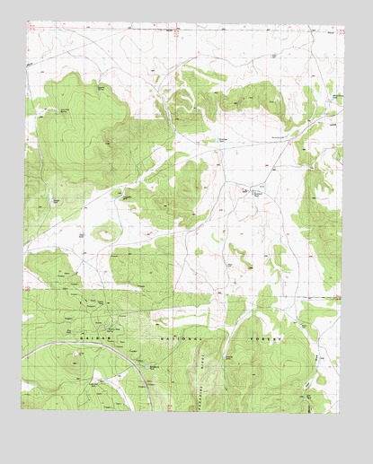
Stanford Tank, AZ USGS Topographic Map
Click on map above to begin viewing in our Map Viewer.

This topographic map contains these locations and features:
Feature Name Type Latitude Longitude GNIS ID View Map
Aja RanchLocaleN35.4467°W112.4127°24165View Map
Antelope TankReservoirN35.4556°W112.4224°25689View Map
Apache SpringSpringN35.4785°W112.4727°25724View Map
Barney Dry DamDamN35.4636°W112.3991°25989View Map
Chinese Tank (historical)ReservoirN35.4162°W112.4685°37710View Map
Con Clair SpringSpringN35.4706°W112.4870°27841View Map
Doe TankReservoirN35.4003°W112.4646°37746View Map
Indian TankReservoirN35.4097°W112.4688°30383View Map
Jimmy TankReservoirN35.3825°W112.4302°40568View Map
Little Aso TankReservoirN35.3842°W112.4718°31030View Map
M K TankReservoirN35.3822°W112.3888°37921View Map
Martin DamDamN35.4028°W112.3918°31540View Map
Martin Dam DrawValleyN35.3944°W112.3843°31541View Map
Paradise TanksReservoirN35.3927°W112.4213°32678View Map
Pouquette TankReservoirN35.4436°W112.4623°33163View Map
Quarry TankReservoirN35.4014°W112.4675°40563View Map
Reneke TankReservoirN35.4420°W112.4898°33573View Map
Sandstone TankReservoirN35.3893°W112.4517°34055View Map
Stanford TankReservoirN35.4460°W112.4106°34797View Map
Tom TankReservoirN35.4389°W112.4682°38117View Map
Upper Sandstone TankReservoirN35.3972°W112.4372°2091485View Map
White Horse TankReservoirN35.4758°W112.3805°38166View Map

Note: Coordinates in the location and feature list above are referenced to NAD83 datum.


Copyright (C) 2008-2025 Ryan Niemi / Sunset Dynamics ... All Rights Reserved