TopoQuest Logo
Do you find TopoQuest useful?
Help keep TopoQuest running and adding new maps/features by donating!
Bitcoin:  19c7KJd3qBynnjoSw5npx9KScwjBe4ifkT
Litecoin:  LXs6TkuXGGXo1vDsWCkWVdjQX94eUKd6ui
Home View Maps Find Maps Find Places Resources & Links


Arsenicker Keys, Florida Topographic Map

USGS Map Title: Arsenicker Keys, FL
USGS Map MRC: 25080D3
DRG (GeoTIFF) Download: o25080d3.tif


Neighboring USGS Topographic Map Quads:


  Goulds, FL  
25080E4
 

  Perrine, FL  
25080E3
 

  Soldier Key, FL  
25080E2
 

  Homestead, FL  
25080D4
 

  Arsenicker Keys, FL  
25080D3
 

  Elliott Key, FL  
25080D2
 

  Glades, FL  
25080C4
 

  Card Sound, FL  
25080C3
 

  Pacific Reef, FL  
25080C2


Map MRC Location:

N26°
W81°
N26°
W80°
H8 H7 H6 H5 H4 H3 H2 H1
G8 G7 G6 G5 G4 G3 G2 G1
F8 F7 F6 F5 F4 F3 F2 F1
E8 E7 E6 E5 E4 E3 E2 E1
D8 D7 D6 D5 D4 D3 D2 D1
C8 C7 C6 C5 C4 C3 C2 C1
B8 B7 B6 B5 B4 B3 B2 B1
A8 A7 A6 A5 A4 A3 A2 A1
N25°
W81°
N25°
W80°

Arsenicker Keys, FL USGS 1:24K Topographic Map Preview:
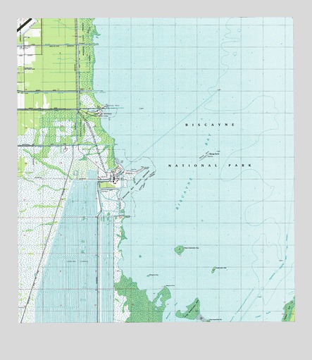
Arsenicker Keys, FL USGS Topographic Map
Click on map above to begin viewing in our Map Viewer.

This topographic map contains these locations and features:
Feature Name Type Latitude Longitude GNIS ID View Map
Arsenicker KeyIslandN25.3971°W80.2864°277962View Map
Canal L 31 ECanalN25.3915°W80.3678°304615View Map
Convoy PointCapeN25.4646°W80.3339°280726View Map
Convoy Point Visitors CenterBuildingN25.4639°W80.3350°2078605View Map
Cutter BankPopulated PlaceN25.3782°W80.2637°304641View Map
East Arsenicker KeyIslandN25.3751°W80.2884°281942View Map
Flaggler Terrace ParkParkN25.4351°W80.2862°304593View Map
Florida Power and Light Turkey Point Power PlantLocaleN25.4350°W80.3311°2481038View Map
FPL Turkey Point HeliportAirportN25.4322°W80.3308°307790View Map
Grand CanalCanalN25.4265°W80.3376°304640View Map
Homestead Bayfront MarinaLocaleN25.4622°W80.3386°2078083View Map
Homestead Bayfront ParkParkN25.4618°W80.3423°284215View Map
IslandiaPopulated PlaceN25.3782°W80.2526°304638View Map
Little RiverStreamN25.4254°W80.3284°285779View Map
Long Arsenicker KeyIslandN25.3804°W80.2953°304995View Map
Mangrove KeyIslandN25.3946°W80.3159°286377View Map
Mangrove PointCapeN25.3901°W80.3084°295801View Map
Mangrove PreserveParkN25.4898°W80.3442°304637View Map
Midnight PassChannelN25.3809°W80.3067°304635View Map
Military CanalCanalN25.4893°W80.3589°286845View Map
Pelican BankBarN25.4437°W80.2895°288663View Map
Sponge RocksPopulated PlaceN25.4434°W80.2892°304639View Map
Turkey PointCapeN25.4387°W80.3173°292538View Map
Turkey Point Nuclear Power PlantLocaleN25.4342°W80.3297°304636View Map
Turtle PointCapeN25.4187°W80.3262°292581View Map
West Arsenicker KeyIslandN25.4054°W80.3017°305000View Map

Note: Coordinates in the location and feature list above are referenced to NAD83 datum.


Copyright (C) 2008-2025 Ryan Niemi / Sunset Dynamics ... All Rights Reserved