TopoQuest Logo
Do you find TopoQuest useful?
Help keep TopoQuest running and adding new maps/features by donating!
Bitcoin:  19c7KJd3qBynnjoSw5npx9KScwjBe4ifkT
Litecoin:  LXs6TkuXGGXo1vDsWCkWVdjQX94eUKd6ui
Home View Maps Find Maps Find Places Resources & Links


Fords Creek, Mississippi Topographic Map

USGS Map Title: Fords Creek, MS
USGS Map MRC: 30089H6
DRG (GeoTIFF) Download: o30089h6.tif


Neighboring USGS Topographic Map Quads:


  Sandy Hook, MS  
31089A7
 

  Baxterville SW, MS  
31089A6
 

  Baxterville, MS  
31089A5
 

  Angie, LA  
30089H7
 

  Fords Creek, MS  
30089H6
 

  Orvisburg, MS  
30089H5
 

  Bogalusa East, LA  
30089G7
 

  White Sand, MS  
30089G6
 

  Poplarville, MS  
30089G5


Map MRC Location:

N31°
W90°
N31°
W89°
H8 H7 H6 H5 H4 H3 H2 H1
G8 G7 G6 G5 G4 G3 G2 G1
F8 F7 F6 F5 F4 F3 F2 F1
E8 E7 E6 E5 E4 E3 E2 E1
D8 D7 D6 D5 D4 D3 D2 D1
C8 C7 C6 C5 C4 C3 C2 C1
B8 B7 B6 B5 B4 B3 B2 B1
A8 A7 A6 A5 A4 A3 A2 A1
N30°
W90°
N30°
W89°

Fords Creek, MS USGS 1:24K Topographic Map Preview:
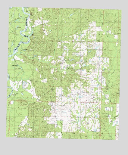
Fords Creek, MS USGS Topographic Map
Click on map above to begin viewing in our Map Viewer.

This topographic map contains these locations and features:
Feature Name Type Latitude Longitude GNIS ID View Map
Aaron LakeLakeN30.9959°W89.7280°666124View Map
Amackertown Volunteer Fire Department Station 2BuildingN30.9050°W89.7255°2332787View Map
Big BranchStreamN30.9782°W89.7431°533054View Map
Bill Williams Lake DamDamN30.8869°W89.6267°680535View Map
Blue LakeLakeN30.9732°W89.7251°667299View Map
Camerons Ferry (historical)CrossingN30.9530°W89.7473°543963View Map
Fords CreekStreamN30.9852°W89.7490°535033View Map
Fords CreekPopulated PlaceN30.9485°W89.6898°670079View Map
Fords CreekStreamN30.9471°W89.7067°670080View Map
Fords Creek ChurchChurchN30.9474°W89.6892°688129View Map
Harry LakeLakeN30.9643°W89.7457°554673View Map
Horseshoe LakeLakeN30.9795°W89.7409°554778View Map
Hunt BluffCliffN30.9930°W89.7276°671586View Map
Hunt LakeLakeN30.9905°W89.7378°554802View Map
James O Ladner Lake DamDamN30.9452°W89.6634°680539View Map
John Henry LakeLakeN30.9586°W89.7321°671899View Map
Little Hell CreekStreamN30.8949°W89.6342°672617View Map
Lower Cameron LakeLakeN30.9416°W89.7349°672911View Map
Mill CreekStreamN30.9560°W89.7415°673593View Map
Richie CemeteryCemeteryN30.8766°W89.7384°676635View Map
Road LakeLakeN30.9875°W89.7412°555809View Map
Ronald French Lake DamDamN30.9569°W89.6517°680540View Map
Stewart SchoolSchoolN30.9241°W89.7001°678285View Map
Twomile CreekStreamN30.9519°W89.6367°679014View Map
Upper Cameron LakeLakeN30.9441°W89.7381°679145View Map
Wesley ChapelChurchN30.9077°W89.7192°679445View Map
White ChapelChurchN30.9844°W89.7120°679580View Map

Note: Coordinates in the location and feature list above are referenced to NAD83 datum.


Copyright (C) 2008-2025 Ryan Niemi / Sunset Dynamics ... All Rights Reserved