TopoQuest Logo
Do you find TopoQuest useful?
Help keep TopoQuest running and adding new maps/features by donating!
Bitcoin:  19c7KJd3qBynnjoSw5npx9KScwjBe4ifkT
Litecoin:  LXs6TkuXGGXo1vDsWCkWVdjQX94eUKd6ui
Home View Maps Find Maps Find Places Resources & Links


Fort Davis, Texas Topographic Map

USGS Map Title: Fort Davis, TX
USGS Map MRC: 30103E8
DRG (GeoTIFF) Download: o30103e8.tif


Neighboring USGS Topographic Map Quads:


  Mount Locke, TX  
30104F1
 

  Casket Mountain, TX  
30103F8
 

  Swayback Mountain, TX  
30103F7
 

  Blue Mountain, TX  
30104E1
 

  Fort Davis, TX  
30103E8
 

  Fort Davis SE, TX  
30103E7
 

  Smith Hills, TX  
30104D1
 

  Mano Prieto Mountain, TX  
30103D8
 

  Mitre Peak, TX  
30103D7


Map MRC Location:

N31°
W104°
N31°
W103°
H8 H7 H6 H5 H4 H3 H2 H1
G8 G7 G6 G5 G4 G3 G2 G1
F8 F7 F6 F5 F4 F3 F2 F1
E8 E7 E6 E5 E4 E3 E2 E1
D8 D7 D6 D5 D4 D3 D2 D1
C8 C7 C6 C5 C4 C3 C2 C1
B8 B7 B6 B5 B4 B3 B2 B1
A8 A7 A6 A5 A4 A3 A2 A1
N30°
W104°
N30°
W103°

Fort Davis, TX USGS 1:24K Topographic Map Preview:
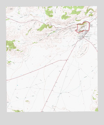
Fort Davis, TX USGS Topographic Map
Click on map above to begin viewing in our Map Viewer.

This topographic map contains these locations and features:
Feature Name Type Latitude Longitude GNIS ID View Map
Arabella MountainSummitN30.6224°W103.9955°1351230View Map
Blue Mountain Airport (historical)AirportN30.5532°W103.9541°1386647View Map
Brushy CanyonValleyN30.6127°W103.9964°1353025View Map
Davis Mountains State ParkParkN30.5960°W103.9302°1355711View Map
Davis Mountains State Park TrailTrailN30.5957°W103.9302°2032832View Map
Devils TankReservoirN30.5981°W103.9824°1355980View Map
Dirks - Anderson Elementary SchoolSchoolN30.5951°W103.8890°1351111View Map
Dolores MountainSummitN30.5682°W103.8949°1356143View Map
Fort DavisPopulated PlaceN30.5882°W103.8946°1357584View Map
Fort Davis Census Designated PlaceCensusN30.5784°W103.8922°2408235View Map
Fort Davis High SchoolSchoolN30.5865°W103.8988°2007191View Map
Fort Davis National Historic SiteParkN30.5993°W103.8962°1357585View Map
Fort Davis Post OfficePost OfficeN30.5949°W103.8862°2731127View Map
Fort Davis Spring (historical)SpringN30.6085°W103.8921°1998472View Map
Fort Davis Volunteer Fire DepartmentBuildingN30.5887°W103.8960°2552046View Map
Grierson-Sproul HouseBuildingN30.5907°W103.9052°2031145View Map
Henry M and Annie V Trueheart HouseBuildingN30.5890°W103.9027°2031073View Map
Hospital CanyonValleyN30.5979°W103.8923°1359690View Map
Jeff Davis County AmbulanceBuildingN30.5887°W103.8959°2656100View Map
Jeff Davis County Sheriff's OfficeBuildingN30.5885°W103.8951°2750416View Map
Keesey CanyonValleyN30.6007°W103.9253°1360516View Map
Lone Tree CreekStreamN30.5557°W103.9857°1374687View Map
Lone Tree HillSummitN30.5571°W103.9982°1361676View Map
Middle Fork Cienega CreekStreamN30.5157°W103.9813°1362722View Map
North Fork Cienega CreekStreamN30.5235°W103.9182°1364052View Map
Olds CreekStreamN30.6138°W103.9766°1364514View Map
Pioneer CemeteryCemeteryN30.5832°W103.8899°1365336View Map
Road CanyonValleyN30.6066°W103.9467°1366540View Map
Rough CanyonValleyN30.6082°W103.9585°1366908View Map
Saint Joseph CemeteryCemeteryN30.5796°W103.8816°1367196View Map
Scobee MountainSummitN30.6174°W103.8852°1367869View Map
Sleeping Lion MountainSummitN30.5952°W103.8974°1368421View Map
South Fork Cienega CreekStreamN30.5235°W103.9182°1376201View Map
Sproul ReservoirReservoirN30.6095°W103.8781°1369046View Map
Tall Grassland TrailTrailN30.6002°W103.8974°2033140View Map
Texas Department of Public Safety Highway Patrol OfficeBuildingN30.5892°W103.8953°2750410View Map

Note: Coordinates in the location and feature list above are referenced to NAD83 datum.


Copyright (C) 2008-2024 Ryan Niemi / Sunset Dynamics ... All Rights Reserved