TopoQuest Logo
Do you find TopoQuest useful?
Help keep TopoQuest running and adding new maps/features by donating!
Bitcoin:  19c7KJd3qBynnjoSw5npx9KScwjBe4ifkT
Litecoin:  LXs6TkuXGGXo1vDsWCkWVdjQX94eUKd6ui
Home View Maps Find Maps Find Places Resources & Links


Fountain Inn, South Carolina Topographic Map

USGS Map Title: Fountain Inn, SC
USGS Map MRC: 34082F2
DRG (GeoTIFF) Download: o34082f2.tif


Neighboring USGS Topographic Map Quads:


  Mauldin, SC  
34082G3
 

  Pelham, SC  
34082G2
 

  Reidville, SC  
34082G1
 

  Simpsonville, SC  
34082F3
 

  Fountain Inn, SC  
34082F2
 

  Woodruff, SC  
34082F1
 

  Fork Shoals, SC  
34082E3
 

  Hickory Tavern, SC  
34082E2
 

  Laurens North, SC  
34082E1


Map MRC Location:

N35°
W83°
N35°
W82°
H8 H7 H6 H5 H4 H3 H2 H1
G8 G7 G6 G5 G4 G3 G2 G1
F8 F7 F6 F5 F4 F3 F2 F1
E8 E7 E6 E5 E4 E3 E2 E1
D8 D7 D6 D5 D4 D3 D2 D1
C8 C7 C6 C5 C4 C3 C2 C1
B8 B7 B6 B5 B4 B3 B2 B1
A8 A7 A6 A5 A4 A3 A2 A1
N34°
W83°
N34°
W82°

Fountain Inn, SC USGS 1:24K Topographic Map Preview:
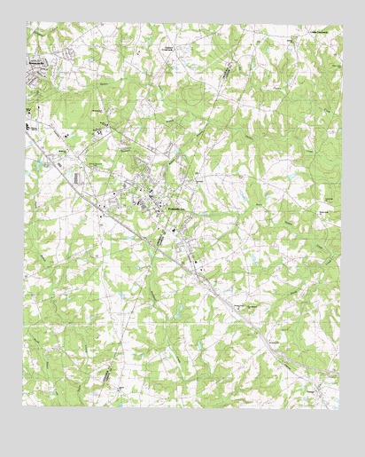
Fountain Inn, SC USGS Topographic Map
Click on map above to begin viewing in our Map Viewer.

This topographic map contains these locations and features:
Feature Name Type Latitude Longitude GNIS ID View Map
Bethany CemeteryCemeteryN34.7440°W82.1437°1234748View Map
Bethany ChurchChurchN34.7446°W82.1446°1246769View Map
Bethany School (historical)SchoolN34.7473°W82.1390°1234750View Map
Bethlehem ChurchChurchN34.7087°W82.2329°1220618View Map
Beulah CemeteryCemeteryN34.6304°W82.2118°1234755View Map
Beulah ChurchChurchN34.6304°W82.2118°1246858View Map
Bryson Elementary SchoolSchoolN34.7168°W82.2176°1251660View Map
Bryson Middle SchoolSchoolN34.7140°W82.2198°1247038View Map
Cannon Memorial ParkCemeteryN34.7027°W82.2221°1221328View Map
City of Fountain InnCivilN34.6992°W82.1995°2403653View Map
Cooks CrossroadsPopulated PlaceN34.7243°W82.1654°1247373View Map
Coopers Large PondReservoirN34.6268°W82.1265°1240251View Map
Coopers Large Pond Dam D-3020DamN34.6268°W82.1265°1240250View Map
Durbin Creek CemeteryCemeteryN34.6882°W82.1337°1234801View Map
Durbin Creek ChurchChurchN34.6885°W82.1340°1247579View Map
Ed Dohar PondReservoirN34.6435°W82.1815°1240238View Map
Ed Dohar Pond Dam D-3007DamN34.6435°W82.1815°1240237View Map
Faith ChurchChurchN34.7212°W82.1504°1247721View Map
Fountain InnPopulated PlaceN34.6890°W82.1957°1222514View Map
Fountain Inn DivisionCivilN34.6494°W82.2422°1938273View Map
Fountain Inn Elementary SchoolSchoolN34.6960°W82.2037°1232004View Map
Fountain Inn Fire Department HeadquartersBuildingN34.6954°W82.2004°2578246View Map
Fountain Inn Municipal CemeteryCemeteryN34.6918°W82.1929°1245162View Map
Fountain Inn Police DepartmentBuildingN34.6951°W82.2006°2734299View Map
Fox Run Country ClubLocaleN34.7404°W82.2057°1245161View Map
Gaylords CrossroadsPopulated PlaceN34.7418°W82.1912°1231309View Map
Gray Court DivisionCivilN34.6371°W82.1308°1938280View Map
Hillcrest High SchoolSchoolN34.7162°W82.2490°1232025View Map
Hillcrest Memorial HospitalHospitalN34.7204°W82.2483°1247920View Map
Howard BranchStreamN34.7196°W82.1804°1223358View Map
Interchange 19CrossingN34.6426°W82.1471°1228342View Map
Interchange 22CrossingN34.6690°W82.1815°1228343View Map
Interchange 23CrossingN34.6804°W82.2029°1228344View Map
Interchange 24CrossingN34.6887°W82.2179°1228345View Map
Interchange 26CrossingN34.7048°W82.2390°1228346View Map
Jays LakeReservoirN34.6804°W82.2080°1239900View Map
Jays Lake Dam D-2912DamN34.6801°W82.2082°1239899View Map
Jones CemeteryCemeteryN34.7009°W82.1642°1223635View Map
Laurens County Fire Department Durbin Creek SubstationBuildingN34.7471°W82.1377°2578204View Map
Martin PondReservoirN34.7031°W82.2446°1239890View Map
Martin Pond Dam D-2906DamN34.7018°W82.2448°1239889View Map
Mount Carmel ChurchChurchN34.6471°W82.1534°1249562View Map
Mount Carmel School (historical)SchoolN34.6487°W82.1543°1234896View Map
Nannies PondReservoirN34.6601°W82.2082°1239902View Map
Nannies Pond Dam D-2913DamN34.6601°W82.2082°1239901View Map
New Durbin ChurchChurchN34.6926°W82.1312°1249795View Map
New Harmony CemeteryCemeteryN34.6586°W82.1613°1234919View Map
New Harmony ChurchChurchN34.6587°W82.1612°1249802View Map
New Liberty ChurchChurchN34.7373°W82.1259°1249839View Map
Old Shady Oak ChurchChurchN34.7212°W82.2193°1232066View Map
OwingsPopulated PlaceN34.6310°W82.1334°1250001View Map
Pine Grove ChurchChurchN34.6996°W82.1826°1234933View Map
Pleasant Grove CemeteryCemeteryN34.6581°W82.1629°1234936View Map
Pleasant Grove ChurchChurchN34.6576°W82.1651°1234937View Map
Pleasant View Church (historical)ChurchN34.6496°W82.2384°1232080View Map
Pleasant View School (historical)SchoolN34.6490°W82.2379°1245288View Map
PoinsettiaPopulated PlaceN34.7323°W82.2437°1245289View Map
PowderhornPopulated PlaceN34.7293°W82.2429°1245291View Map
Powers Shop (historical)Populated PlaceN34.6418°W82.1498°1234943View Map
Reedy CreekStreamN34.6751°W82.1276°1225815View Map
Riddle Pond Dam D-2966DamN34.7018°W82.1448°1240185View Map
Simpsonville DivisionCivilN34.7367°W82.2444°1938422View Map
Sure Trans Medical TransportBuildingN34.7392°W82.2375°2739612View Map
Thads PondReservoirN34.7009°W82.2493°1239888View Map
Thads Pond Dam D-2905DamN34.7001°W82.2498°1239887View Map
The CedarsPopulated PlaceN34.7357°W82.2459°1245354View Map
Waycross School (historical)SchoolN34.7326°W82.1987°1232125View Map
WFIS-AM (Fountain Inn)TowerN34.7079°W82.2276°1252348View Map
Wilson CreekStreamN34.7185°W82.1771°1251463View Map

Note: Coordinates in the location and feature list above are referenced to NAD83 datum.


Copyright (C) 2008-2025 Ryan Niemi / Sunset Dynamics ... All Rights Reserved