TopoQuest Logo
Do you find TopoQuest useful?
Help keep TopoQuest running and adding new maps/features by donating!
Bitcoin:  19c7KJd3qBynnjoSw5npx9KScwjBe4ifkT
Litecoin:  LXs6TkuXGGXo1vDsWCkWVdjQX94eUKd6ui
Home View Maps Find Maps Find Places Resources & Links


Hickory Tavern, South Carolina Topographic Map

USGS Map Title: Hickory Tavern, SC
USGS Map MRC: 34082E2
DRG (GeoTIFF) Download: o34082e2.tif


Neighboring USGS Topographic Map Quads:


  Simpsonville, SC  
34082F3
 

  Fountain Inn, SC  
34082F2
 

  Woodruff, SC  
34082F1
 

  Fork Shoals, SC  
34082E3
 

  Hickory Tavern, SC  
34082E2
 

  Laurens North, SC  
34082E1
 

  Ware Shoals West, SC  
34082D3
 

  Ware Shoals East, SC  
34082D2
 

  Laurens South, SC  
34082D1


Map MRC Location:

N35°
W83°
N35°
W82°
H8 H7 H6 H5 H4 H3 H2 H1
G8 G7 G6 G5 G4 G3 G2 G1
F8 F7 F6 F5 F4 F3 F2 F1
E8 E7 E6 E5 E4 E3 E2 E1
D8 D7 D6 D5 D4 D3 D2 D1
C8 C7 C6 C5 C4 C3 C2 C1
B8 B7 B6 B5 B4 B3 B2 B1
A8 A7 A6 A5 A4 A3 A2 A1
N34°
W83°
N34°
W82°

Hickory Tavern, SC USGS 1:24K Topographic Map Preview:
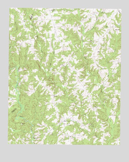
Hickory Tavern, SC USGS Topographic Map
Click on map above to begin viewing in our Map Viewer.

This topographic map contains these locations and features:
Feature Name Type Latitude Longitude GNIS ID View Map
Arnolds Mill (historical)LocaleN34.5065°W82.2229°1234735View Map
Babb CemeteryCemeteryN34.6112°W82.2240°1220270View Map
Babb Pond Dam D-3018DamN34.5718°W82.1998°1240247View Map
Campbell ChapelChurchN34.5857°W82.1484°1234768View Map
Center Rabon ChurchChurchN34.5723°W82.1884°1247231View Map
Center Rabon School (historical)SchoolN34.5718°W82.1890°1234772View Map
Currys LakeReservoirN34.6082°W82.1409°1247466View Map
Dials CemeteryCemeteryN34.5951°W82.1576°1234796View Map
Dials ChurchChurchN34.5943°W82.1590°1247527View Map
Edens (historical)Populated PlaceN34.5757°W82.1837°1234803View Map
Edens School (historical)SchoolN34.5798°W82.1859°1234804View Map
Green PondPopulated PlaceN34.6232°W82.2032°1234833View Map
Green Pond CemeteryCemeteryN34.6229°W82.2026°1234834View Map
Green Pond ChurchChurchN34.6229°W82.2051°1245832View Map
Green Pond School (historical)SchoolN34.6232°W82.2043°1234835View Map
Henderson CemeteryCemeteryN34.5093°W82.2009°1234843View Map
Henderson ChurchChurchN34.5093°W82.2009°1245954View Map
Hickory TavernPopulated PlaceN34.5212°W82.1887°1245972View Map
Hickory Tavern SchoolSchoolN34.5190°W82.1871°1234844View Map
Horse CreekStreamN34.5112°W82.2234°1223310View Map
Laurens County Fire Department GreenpondBuildingN34.6187°W82.2050°2578173View Map
Laurens County Fire Department Hickory Tavern Station 1BuildingN34.5239°W82.1870°2578394View Map
Lick CreekStreamN34.5126°W82.1340°1223900View Map
Martin CreekStreamN34.5712°W82.2409°1224340View Map
Mill Rock ChurchChurchN34.5421°W82.1432°1246668View Map
Mill Rock School (historical)SchoolN34.5421°W82.1434°1234893View Map
Mountain CreekStreamN34.5537°W82.1468°1224852View Map
New Prospect CemeteryCemeteryN34.5187°W82.2351°1234921View Map
New Prospect ChurchChurchN34.5182°W82.2346°1249849View Map
Payne BranchStreamN34.6185°W82.2307°1225327View Map
Pumpkin BranchStreamN34.6026°W82.1671°1234947View Map
Rabon Creek ChurchChurchN34.5448°W82.1993°1250282View Map
Rabun Creek CemeteryCemeteryN34.5454°W82.1979°1234948View Map
Reedy River (historical)Populated PlaceN34.5071°W82.2207°1234950View Map
Riddle PondReservoirN34.5418°W82.2432°1239894View Map
Riddle Pond Dam D-2909DamN34.5418°W82.2432°1239893View Map
Rocky Mount School (historical)SchoolN34.5787°W82.2201°1235319View Map
Shiloh ChurchChurchN34.5346°W82.1509°1250872View Map
Stoddard CreekStreamN34.6112°W82.1698°1226895View Map
Sullivan Mill (historical)LocaleN34.5062°W82.2221°1234980View Map
Tumbling ShoalsRapidsN34.5062°W82.2223°1251229View Map
Tumbling Shoals (historical)Populated PlaceN34.5057°W82.2248°1234987View Map

Note: Coordinates in the location and feature list above are referenced to NAD83 datum.


Copyright (C) 2008-2024 Ryan Niemi / Sunset Dynamics ... All Rights Reserved