TopoQuest Logo
Do you find TopoQuest useful?
Help keep TopoQuest running and adding new maps/features by donating!
Bitcoin:  19c7KJd3qBynnjoSw5npx9KScwjBe4ifkT
Litecoin:  LXs6TkuXGGXo1vDsWCkWVdjQX94eUKd6ui
Home View Maps Find Maps Find Places Resources & Links


Fox Lake, Utah Topographic Map

USGS Map Title: Fox Lake, UT
USGS Map MRC: 40110G2
DRG (GeoTIFF) Download: o40110g2.tif


Neighboring USGS Topographic Map Quads:


  Gilbert Peak NE, UT  
40110H3
 

  Hole In The Rock, UT  
40110H2
 

  Hoop Lake, UT  
40110H1
 

  Kings Peak, UT  
40110G3
 

  Fox Lake, UT  
40110G2
 

  Chepeta Lake, UT  
40110G1
 

  Mount Emmons, UT  
40110F3
 

  Bollie Lake, UT  
40110F2
 

  Rasmussen Lakes, UT  
40110F1


Map MRC Location:

N41°
W111°
N41°
W110°
H8 H7 H6 H5 H4 H3 H2 H1
G8 G7 G6 G5 G4 G3 G2 G1
F8 F7 F6 F5 F4 F3 F2 F1
E8 E7 E6 E5 E4 E3 E2 E1
D8 D7 D6 D5 D4 D3 D2 D1
C8 C7 C6 C5 C4 C3 C2 C1
B8 B7 B6 B5 B4 B3 B2 B1
A8 A7 A6 A5 A4 A3 A2 A1
N40°
W111°
N40°
W110°

Fox Lake, UT USGS 1:24K Topographic Map Preview:
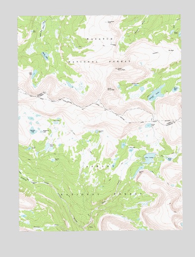
Fox Lake, UT USGS Topographic Map
Click on map above to begin viewing in our Map Viewer.

This topographic map contains these locations and features:
Feature Name Type Latitude Longitude GNIS ID View Map
Beaver LakeLakeN40.8517°W110.2296°1438535View Map
Bennion LakeLakeN40.8342°W110.1602°1438605View Map
Bowden LakeLakeN40.7912°W110.2242°1439046View Map
Brook LakeLakeN40.7912°W110.1357°1439156View Map
Coffin LakeLakeN40.8413°W110.2382°1439860View Map
Corral MeadowsFlatN40.8649°W110.2196°1454709View Map
Craig LakeLakeN40.7591°W110.2472°1454711View Map
Crescent LakeReservoirN40.7854°W110.1590°1447965View Map
Crescent Lake DamDamN40.7866°W110.1540°1447966View Map
Davis LakesLakeN40.8128°W110.2221°1440289View Map
Dime LakeLakeN40.7965°W110.1648°1440461View Map
Dine LakeLakeN40.8659°W110.2397°1440462View Map
Divide LakeLakeN40.8107°W110.1515°1440477View Map
Fox LakeReservoirN40.7918°W110.1509°1447969View Map
Fox Lake DamDamN40.7916°W110.1557°1447970View Map
Fox Queant PassGapN40.7774°W110.1382°1454743View Map
Gilbert CreekStreamN40.7786°W110.2404°1441316View Map
Island LakeLakeN40.8290°W110.1452°1442065View Map
Island Lake DamDamN40.8249°W110.1507°1447977View Map
Kabell LakeLakeN40.8639°W110.1264°1442262View Map
Kabell RidgeRidgeN40.8533°W110.1268°1442263View Map
Kidney LakesLakeN40.7991°W110.2288°1442309View Map
Long MeadowFlatN40.8722°W110.2207°1454801View Map
North Burro PeakSummitN40.8438°W110.1749°1443853View Map
North Fork ParkParkN40.7780°W110.2390°1443924View Map
Rainbow LakeLakeN40.8082°W110.2396°1444717View Map
Round LakeLakeN40.8316°W110.1307°1445167View Map
Samuels LakeLakeN40.8076°W110.1907°1455904View Map
Shale CreekStreamN40.7513°W110.2010°1445466View Map
Shale Creek BridgeBridgeN40.7569°W110.1960°1454889View Map
Shale DugwayTrailN40.7522°W110.1974°1445467View Map
South Burro PeakSummitN40.8319°W110.1832°1445798View Map
Thompson PassGapN40.8577°W110.1754°1446546View Map
Thompson PeakSummitN40.8711°W110.1824°1446547View Map
Uinta Canyon Forest Service StationLocaleN40.7847°W110.1910°1454932View Map
Verlie LakeLakeN40.7980°W110.2428°1446925View Map
Weeping Ledge LakeLakeN40.8172°W110.2347°1454945View Map
Wilderness LakeLakeN40.8130°W110.2360°1454949View Map

Note: Coordinates in the location and feature list above are referenced to NAD83 datum.


Copyright (C) 2008-2025 Ryan Niemi / Sunset Dynamics ... All Rights Reserved