TopoQuest Logo
Do you find TopoQuest useful?
Help keep TopoQuest running and adding new maps/features by donating!
Bitcoin:  19c7KJd3qBynnjoSw5npx9KScwjBe4ifkT
Litecoin:  LXs6TkuXGGXo1vDsWCkWVdjQX94eUKd6ui
Home View Maps Find Maps Find Places Resources & Links


Rasmussen Lakes, Utah Topographic Map

USGS Map Title: Rasmussen Lakes, UT
USGS Map MRC: 40110F1
DRG (GeoTIFF) Download: o40110f1.tif


Neighboring USGS Topographic Map Quads:


  Fox Lake, UT  
40110G2
 

  Chepeta Lake, UT  
40110G1
 

  Whiterocks Lake, UT  
40109G8
 

  Bollie Lake, UT  
40110F2
 

  Rasmussen Lakes, UT  
40110F1
 

  Paradise Park, UT  
40109F8
 

  Heller Lake, UT  
40110E2
 

  Dark Canyon, UT  
40110E1
 

  Ice Cave Peak, UT  
40109E8


Map MRC Location:

N41°
W111°
N41°
W110°
H8 H7 H6 H5 H4 H3 H2 H1
G8 G7 G6 G5 G4 G3 G2 G1
F8 F7 F6 F5 F4 F3 F2 F1
E8 E7 E6 E5 E4 E3 E2 E1
D8 D7 D6 D5 D4 D3 D2 D1
C8 C7 C6 C5 C4 C3 C2 C1
B8 B7 B6 B5 B4 B3 B2 B1
A8 A7 A6 A5 A4 A3 A2 A1
N40°
W111°
N40°
W110°

Rasmussen Lakes, UT USGS 1:24K Topographic Map Preview:
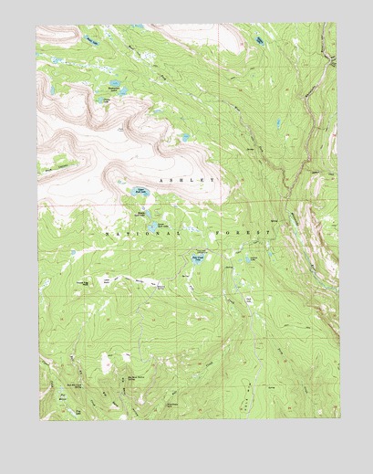
Rasmussen Lakes, UT USGS Topographic Map
Click on map above to begin viewing in our Map Viewer.

This topographic map contains these locations and features:
Feature Name Type Latitude Longitude GNIS ID View Map
Ashley National ForestForestN40.6466°W110.0990°1448007View Map
Bennion ParkFlatN40.6683°W110.0810°1438606View Map
Bennion SpringSpringN40.6669°W110.0771°1438608View Map
Big BendBendN40.6283°W110.0924°1438637View Map
Big Bend HollowValleyN40.6255°W110.0840°1438638View Map
Big Bend Hollow SpringSpringN40.6382°W110.0893°1438639View Map
Bull Elk Creek SpringSpringN40.6356°W110.1078°1439266View Map
Cirque LakeLakeN40.7261°W110.0990°1439751View Map
Cliff CreekStreamN40.7369°W110.0040°1439811View Map
Davis ParkFlatN40.6622°W110.0382°1440290View Map
East Fork Whiterocks RiverStreamN40.7380°W110.0035°1440825View Map
Frog LakeLakeN40.6277°W110.1123°1441245View Map
Goose Egg PeakSummitN40.6680°W110.1040°1441368View Map
Hidden LakeLakeN40.7443°W110.0327°1441741View Map
Island LakeReservoirN40.6816°W110.0174°1447914View Map
Island Lake DamDamN40.6816°W110.0174°1447915View Map
Johnson CreekStreamN40.7038°W110.0157°1442180View Map
Larvae LakeLakeN40.6752°W110.0386°1442445View Map
Little BasinBasinN40.6688°W110.0974°1442656View Map
Lower Rock LakeLakeN40.6858°W110.0778°1443024View Map
Lucky SpringSpringN40.6704°W110.0667°1454809View Map
Middle Rock LakeLakeN40.6901°W110.0798°1443377View Map
Point LakeLakeN40.7448°W110.1025°1444495View Map
Pole Creek CampgroundLocaleN40.6786°W110.0599°1444545View Map
Pole Creek LakeLakeN40.6756°W110.0594°1444548View Map
Pole Creek SinkBasinN40.6297°W110.0732°1444549View Map
Pole MountainSummitN40.6316°W110.0382°1444560View Map
Pot HolesLakeN40.6326°W110.1164°1444603View Map
Rasmussen LakesLakeN40.7313°W110.0928°1444726View Map
Upper Rock LakeLakeN40.6971°W110.0830°1446879View Map
West Fork Whiterocks RiverStreamN40.6969°W110.0204°1447156View Map

Note: Coordinates in the location and feature list above are referenced to NAD83 datum.


Copyright (C) 2008-2025 Ryan Niemi / Sunset Dynamics ... All Rights Reserved