TopoQuest Logo
Do you find TopoQuest useful?
Help keep TopoQuest running and adding new maps/features by donating!
Bitcoin:  19c7KJd3qBynnjoSw5npx9KScwjBe4ifkT
Litecoin:  LXs6TkuXGGXo1vDsWCkWVdjQX94eUKd6ui
Home View Maps Find Maps Find Places Resources & Links


Foxtail Lake, Nevada Topographic Map

USGS Map Title: Foxtail Lake, NV
USGS Map MRC: 39118E4
DRG (GeoTIFF) Download: o39118e4.tif


Neighboring USGS Topographic Map Quads:


  Stillwater NE, NV  
39118F5
 

  Pintail Bay, NV  
39118F4
 

  Cox Canyon, NV  
39118F3
 

  Stillwater, NV  
39118E5
 

  Foxtail Lake, NV  
39118E4
 

  Table Mountain, NV  
39118E3
 

  Lahontan Mountains, NV  
39118D5
 

  Diamond Canyon, NV  
39118D4
 

  La Plata Canyon, NV  
39118D3


Map MRC Location:

N40°
W119°
N40°
W118°
H8 H7 H6 H5 H4 H3 H2 H1
G8 G7 G6 G5 G4 G3 G2 G1
F8 F7 F6 F5 F4 F3 F2 F1
E8 E7 E6 E5 E4 E3 E2 E1
D8 D7 D6 D5 D4 D3 D2 D1
C8 C7 C6 C5 C4 C3 C2 C1
B8 B7 B6 B5 B4 B3 B2 B1
A8 A7 A6 A5 A4 A3 A2 A1
N39°
W119°
N39°
W118°

Foxtail Lake, NV USGS 1:24K Topographic Map Preview:
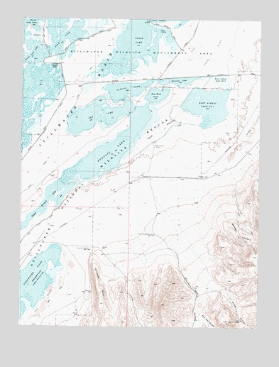
Foxtail Lake, NV USGS Topographic Map
Click on map above to begin viewing in our Map Viewer.

This topographic map contains these locations and features:
Feature Name Type Latitude Longitude GNIS ID View Map
Cattail LakeReservoirN39.5962°W118.4463°839358View Map
Division LakeReservoirN39.6008°W118.4307°840063View Map
Dog Head PondReservoirN39.5942°W118.4303°840080View Map
Dry LakeReservoirN39.5852°W118.4616°840181View Map
East Alkali Lake Number OneReservoirN39.5901°W118.4036°840253View Map
East Alkali Lake Number TwoReservoirN39.6005°W118.3964°840254View Map
East CanalCanalN39.5585°W118.4640°840259View Map
East PastureFlatN39.5802°W118.4290°840279View Map
East Pasture CorralLocaleN39.5738°W118.4315°840280View Map
Fourmile Point WellWellN39.5313°W118.4660°840545View Map
Foxtail LakeReservoirN39.5719°W118.4545°840554View Map
Goose LakeReservoirN39.6142°W118.4425°840723View Map
Goose Lake BypassCanalN39.6216°W118.4021°850761View Map
Goose LandingLocaleN39.6210°W118.4296°856038View Map
Hunter DrainCanalN39.5835°W118.4860°841206View Map
Lead Lake CanalCanalN39.6185°W118.4638°841595View Map
Lower Sheep Canyon WellWellN39.5027°W118.3849°841869View Map
Mountain Well CanyonValleyN39.5371°W118.4279°856324View Map
Mud Hole CanyonValleyN39.5071°W118.4085°842289View Map
Pappis PondReservoirN39.6063°W118.4843°842715View Map
Point of the Mountain WellWellN39.5377°W118.4326°842898View Map
Rice LandingLocaleN39.6241°W118.4354°856118View Map
Sheep CanyonValleyN39.5330°W118.4107°843616View Map
Shirttail CanyonValleyN39.5549°W118.4032°843665View Map
Shirttail WellWellN39.5613°W118.4051°843666View Map
South Lead LakeReservoirN39.6004°W118.4971°843880View Map
Stillwater MarshSwampN39.6141°W118.4507°848653View Map
Stillwater National Wildlife RefugeParkN39.6213°W118.4647°846018View Map
Stillwater PointCliffN39.5180°W118.4604°844009View Map
Stillwater Point DamDamN39.5316°W118.4810°863592View Map
Tule LakeReservoirN39.6188°W118.4721°844441View Map
Upper Foxtail LakeReservoirN39.5512°W118.4857°844539View Map
West CanalCanalN39.5752°W118.4815°844715View Map
West PastureFlatN39.5649°W118.4968°850762View Map
West Ripley Canyon WellWellN39.5530°W118.4101°847664View Map

Note: Coordinates in the location and feature list above are referenced to NAD83 datum.


Copyright (C) 2008-2025 Ryan Niemi / Sunset Dynamics ... All Rights Reserved