TopoQuest Logo
Do you find TopoQuest useful?
Help keep TopoQuest running and adding new maps/features by donating!
Bitcoin:  19c7KJd3qBynnjoSw5npx9KScwjBe4ifkT
Litecoin:  LXs6TkuXGGXo1vDsWCkWVdjQX94eUKd6ui
Home View Maps Find Maps Find Places Resources & Links


Cox Canyon, Nevada Topographic Map

USGS Map Title: Cox Canyon, NV
USGS Map MRC: 39118F3
DRG (GeoTIFF) Download: o39118f3.tif


Neighboring USGS Topographic Map Quads:


  Lone Rock SW, NV  
39118G4
 

  Lone Rock SE, NV  
39118G3
 

  Fondaway Canyon, NV  
39118G2
 

  Pintail Bay, NV  
39118F4
 

  Cox Canyon, NV  
39118F3
 

  I X L Canyon, NV  
39118F2
 

  Foxtail Lake, NV  
39118E4
 

  Table Mountain, NV  
39118E3
 

  Job Peak, NV  
39118E2


Map MRC Location:

N40°
W119°
N40°
W118°
H8 H7 H6 H5 H4 H3 H2 H1
G8 G7 G6 G5 G4 G3 G2 G1
F8 F7 F6 F5 F4 F3 F2 F1
E8 E7 E6 E5 E4 E3 E2 E1
D8 D7 D6 D5 D4 D3 D2 D1
C8 C7 C6 C5 C4 C3 C2 C1
B8 B7 B6 B5 B4 B3 B2 B1
A8 A7 A6 A5 A4 A3 A2 A1
N39°
W119°
N39°
W118°

Cox Canyon, NV USGS 1:24K Topographic Map Preview:
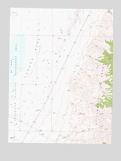
Cox Canyon, NV USGS Topographic Map
Click on map above to begin viewing in our Map Viewer.

This topographic map contains these locations and features:
Feature Name Type Latitude Longitude GNIS ID View Map
Cox CanyonValleyN39.6977°W118.2960°839814View Map
Desert WellWellN39.6552°W118.3415°848533View Map
Dry CanyonValleyN39.6660°W118.3035°840138View Map
Government SpringSpringN39.6294°W118.3732°848553View Map
High Rock SpringSpringN39.6527°W118.2851°847614View Map
Jobs Canyon SpringSpringN39.6485°W118.2879°847613View Map
Kent CanyonValleyN39.7210°W118.2796°841472View Map
Lambing CanyonValleyN39.6535°W118.3076°841559View Map
Mill SpringSpringN39.7471°W118.2553°863185View Map
Poco CanyonValleyN39.6269°W118.3201°842895View Map
Poco WellWellN39.6333°W118.3362°842896View Map
Salina Mining DistrictCivilN39.7188°W118.3274°856986View Map
Salinas (historical)LocaleN39.7110°W118.3015°857555View Map
Salinas Post Office (historical)Post OfficeN39.7110°W118.3015°864487View Map
Silver Hill CanyonValleyN39.7094°W118.2912°843701View Map
Silver Hill CreekStreamN39.7135°W118.3082°847598View Map
Silver Station (historical)LocaleN39.6402°W118.3479°847637View Map
West Job CanyonValleyN39.6405°W118.3074°844726View Map

Note: Coordinates in the location and feature list above are referenced to NAD83 datum.


Copyright (C) 2008-2025 Ryan Niemi / Sunset Dynamics ... All Rights Reserved