TopoQuest Logo
Do you find TopoQuest useful?
Help keep TopoQuest running and adding new maps/features by donating!
Bitcoin:  19c7KJd3qBynnjoSw5npx9KScwjBe4ifkT
Litecoin:  LXs6TkuXGGXo1vDsWCkWVdjQX94eUKd6ui
Home View Maps Find Maps Find Places Resources & Links


Fred, Louisiana Topographic Map

USGS Map Title: Fred, LA
USGS Map MRC: 30091F1
DRG (GeoTIFF) Download: o30091f1.tif


Neighboring USGS Topographic Map Quads:


  Jackson, LA  
30091G2
 

  Clinton, LA  
30091G1
 

  Bluff Creek, LA  
30090G8
 

  Zachary, LA  
30091F2
 

  Fred, LA  
30091F1
 

  Pride, LA  
30090F8
 

  Scotlandville, LA  
30091E2
 

  Comite, LA  
30091E1
 

  Watson, LA  
30090E8


Map MRC Location:

N31°
W92°
N31°
W91°
H8 H7 H6 H5 H4 H3 H2 H1
G8 G7 G6 G5 G4 G3 G2 G1
F8 F7 F6 F5 F4 F3 F2 F1
E8 E7 E6 E5 E4 E3 E2 E1
D8 D7 D6 D5 D4 D3 D2 D1
C8 C7 C6 C5 C4 C3 C2 C1
B8 B7 B6 B5 B4 B3 B2 B1
A8 A7 A6 A5 A4 A3 A2 A1
N30°
W92°
N30°
W91°

Fred, LA USGS 1:24K Topographic Map Preview:
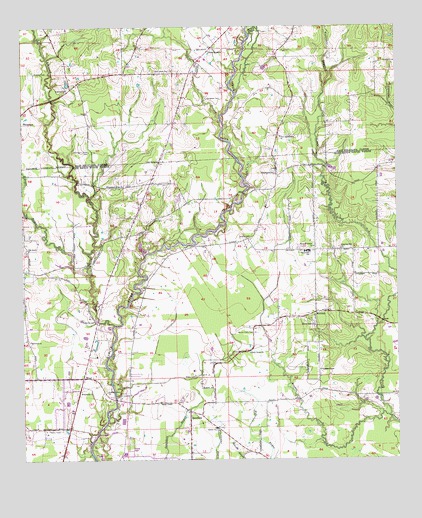
Fred, LA USGS Topographic Map
Click on map above to begin viewing in our Map Viewer.

This topographic map contains these locations and features:
Feature Name Type Latitude Longitude GNIS ID View Map
Annison Private AirportAirportN30.7058°W91.0598°1632946View Map
Ballard CemeteryCemeteryN30.6891°W91.0526°532291View Map
Beaver CreekStreamN30.6374°W91.0032°532855View Map
Black CemeteryCemeteryN30.6493°W91.0682°533181View Map
Chaneyville Community CenterBuildingN30.6862°W91.0238°2601305View Map
Chaneyville School (historical)SchoolN30.6855°W91.0293°533873View Map
Chaneyville Volunteer Fire DepartmentBuildingN30.6851°W91.0270°2332458View Map
Country Breeze AirportAirportN30.7238°W91.0741°2676740View Map
Cypress Grove ChurchChurchN30.6449°W91.0976°534369View Map
DeerfordPopulated PlaceN30.6391°W91.0695°554216View Map
Deerford Methodist ChurchChurchN30.6394°W91.0698°553146View Map
Deerford Post Office (historical)Post OfficeN30.6388°W91.0695°1632084View Map
Douglass CemeteryCemeteryN30.7296°W91.0629°534576View Map
Doyle BayouStreamN30.6791°W91.1032°554261View Map
East Baton Rouge Parish Library Pride - Chaneyville BranchBuildingN30.7049°W91.0173°2603054View Map
Eastside Baptist ChurchChurchN30.6446°W91.1059°554334View Map
FredPopulated PlaceN30.6488°W91.1054°543220View Map
Galilee Baptist ChurchChurchN30.6341°W91.0609°554501View Map
Greater Oak Grove Baptist ChurchChurchN30.6970°W91.0872°2601856View Map
Holly Grove ChurchChurchN30.6560°W91.0495°535723View Map
Junior Deputy CampLocaleN30.6580°W91.0009°553225View Map
Kingdom Hall ChurchChurchN30.6863°W91.0190°1964807View Map
Little Ezion ChurchChurchN30.7116°W91.0793°536543View Map
MilldalePopulated PlaceN30.6677°W91.0276°537123View Map
Milldale Baptist ChurchChurchN30.6649°W91.0393°2602256View Map
Moses ChapelChurchN30.6416°W91.0798°537243View Map
Mount Holly CemeteryCemeteryN30.6618°W91.0479°537325View Map
Mount Pleasant ChurchChurchN30.6869°W91.0279°537389View Map
Mount Wade ChurchChurchN30.6641°W91.0279°537418View Map
New Philadelphia ChurchChurchN30.7185°W91.0387°537616View Map
Northeast Elementary SchoolSchoolN30.7060°W91.0145°557653View Map
Northeast High SchoolSchoolN30.7032°W91.0120°2434802View Map
Oak Grove Baptist Church Number 1ChurchN30.6860°W91.1237°555524View Map
Olive BranchStreamN30.7246°W91.0584°537870View Map
Olive BranchPopulated PlaceN30.7441°W91.0620°541160View Map
Overton CemeteryCemeteryN30.7371°W91.1207°537920View Map
Parish Governing Authority District 1CivilN30.6426°W91.1048°1929733View Map
Philadelphia ChurchChurchN30.7080°W91.0404°538101View Map
Pine Grove ChurchChurchN30.7377°W91.0759°538169View Map
Redwood Baptist ChurchChurchN30.6594°W91.1229°555786View Map
Redwood CemeteryCemeteryN30.6655°W91.1009°538547View Map
Redwood ChurchChurchN30.7321°W91.1101°538548View Map
Redwood CreekStreamN30.6641°W91.0948°555787View Map
Rock Church and World MinistriesChurchN30.6536°W91.1032°2602347View Map
Schlei BayouStreamN30.7480°W91.0487°553253View Map
Strangers Home CemeteryCemeteryN30.7143°W91.1026°539687View Map
Strangers Home ChurchChurchN30.7044°W91.0968°539688View Map
Waterfall BayouStreamN30.7330°W91.0237°540249View Map
Whitehead Ultralight FlightparkAirportN30.6752°W91.1149°1633019View Map
Winding ChapelChurchN30.6510°W91.0262°540496View Map

Note: Coordinates in the location and feature list above are referenced to NAD83 datum.


Copyright (C) 2008-2024 Ryan Niemi / Sunset Dynamics ... All Rights Reserved