TopoQuest Logo
Do you find TopoQuest useful?
Help keep TopoQuest running and adding new maps/features by donating!
Bitcoin:  19c7KJd3qBynnjoSw5npx9KScwjBe4ifkT
Litecoin:  LXs6TkuXGGXo1vDsWCkWVdjQX94eUKd6ui
Home View Maps Find Maps Find Places Resources & Links


Frozen Point, Texas Topographic Map

USGS Map Title: Frozen Point, TX
USGS Map MRC: 29094E5
DRG (GeoTIFF) Download: o29094e5.tif


Neighboring USGS Topographic Map Quads:


  Oak Island, TX  
29094F6
 

  Oyster Bayou, TX  
29094F5
 

  Stanolind Reservoir, TX  
29094F4
 

  Lake Stephenson, TX  
29094E6
 

  Frozen Point, TX  
29094E5
 

  High Island, TX  
29094E4
 

  Flake, TX  
29094D6
 

  Caplen, TX  
29094D5


Map MRC Location:

N30°
W95°
N30°
W94°
H8 H7 H6 H5 H4 H3 H2 H1
G8 G7 G6 G5 G4 G3 G2 G1
F8 F7 F6 F5 F4 F3 F2 F1
E8 E7 E6 E5 E4 E3 E2 E1
D8 D7 D6 D5 D4 D3 D2 D1
C8 C7 C6 C5 C4 C3 C2 C1
B8 B7 B6 B5 B4 B3 B2 B1
A8 A7 A6 A5 A4 A3 A2 A1
N29°
W95°
N29°
W94°

Frozen Point, TX USGS 1:24K Topographic Map Preview:
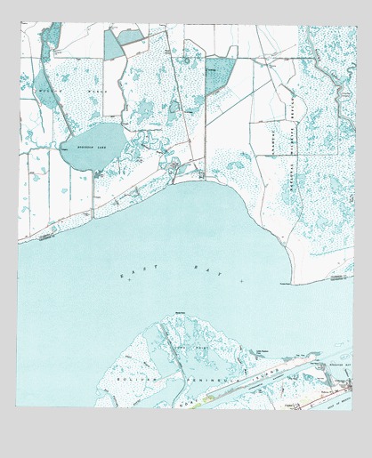
Frozen Point, TX USGS Topographic Map
Click on map above to begin viewing in our Map Viewer.

This topographic map contains these locations and features:
Feature Name Type Latitude Longitude GNIS ID View Map
Anahuac National Wildlife Refuge TrailTrailN29.5669°W94.5335°2032986View Map
Cane BayouGutN29.5991°W94.5855°1372912View Map
Coulter IslandIslandN29.6041°W94.5038°1333498View Map
East Robinson Lake Gas FieldOilfieldN29.5730°W94.5838°1334982View Map
Frozen PointCapeN29.5411°W94.5235°1336281View Map
Ghost BayouGutN29.5130°W94.5749°1336508View Map
Little Pasture BayouGutN29.5147°W94.5396°1374597View Map
Little Pasture CoveBayN29.5191°W94.5363°1340150View Map
Long PointCapeN29.5200°W94.5607°1340499View Map
Marsh PointCapeN29.5316°W94.5666°1340987View Map
Open LakesLakeN29.6163°W94.5674°1343293View Map
Robinson BayouStreamN29.5734°W94.5698°1345326View Map
Robinson LakeLakeN29.5847°W94.5970°1345338View Map
RolloverPopulated PlaceN29.5061°W94.5069°1378983View Map
Rollover PassCanalN29.5083°W94.5005°1345528View Map
Sun Oil Company CanalCanalN29.5122°W94.5632°1348063View Map
Sun Oil Company CanalCanalN29.5166°W94.5666°1385143View Map
Willow MarshSwampN29.5966°W94.6157°1350201View Map

Note: Coordinates in the location and feature list above are referenced to NAD83 datum.


Copyright (C) 2008-2025 Ryan Niemi / Sunset Dynamics ... All Rights Reserved