TopoQuest Logo
Do you find TopoQuest useful?
Help keep TopoQuest running and adding new maps/features by donating!
Bitcoin:  19c7KJd3qBynnjoSw5npx9KScwjBe4ifkT
Litecoin:  LXs6TkuXGGXo1vDsWCkWVdjQX94eUKd6ui
Home View Maps Find Maps Find Places Resources & Links


Gaastra, Michigan Topographic Map

USGS Map Title: Gaastra, MI
USGS Map MRC: 46088A5
DRG (GeoTIFF) Download: o46088a5.tif


Neighboring USGS Topographic Map Quads:


  Gibbs City, MI  
46088B6
 

  Sunset Lake, MI  
46088B5
 

  Amasa, MI  
46088B4
 

  Iron River, MI  
46088A6
 

  Gaastra, MI  
46088A5
 

  Fortune Lakes, MI  
46088A4
 

  Tipler, WI  
45088H6
 

  Long Lake NE, WI  
45088H5
 

  Naults, MI  
45088H4


Map MRC Location:

N47°
W89°
N47°
W88°
H8 H7 H6 H5 H4 H3 H2 H1
G8 G7 G6 G5 G4 G3 G2 G1
F8 F7 F6 F5 F4 F3 F2 F1
E8 E7 E6 E5 E4 E3 E2 E1
D8 D7 D6 D5 D4 D3 D2 D1
C8 C7 C6 C5 C4 C3 C2 C1
B8 B7 B6 B5 B4 B3 B2 B1
A8 A7 A6 A5 A4 A3 A2 A1
N46°
W89°
N46°
W88°

Gaastra, MI USGS 1:24K Topographic Map Preview:
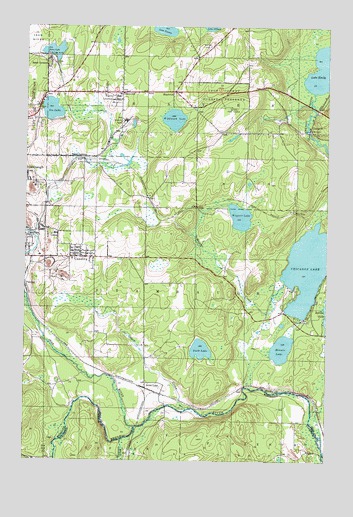
Gaastra, MI USGS Topographic Map
Click on map above to begin viewing in our Map Viewer.

This topographic map contains these locations and features:
Feature Name Type Latitude Longitude GNIS ID View Map
Aspirus Iron River HospitalHospitalN46.0998°W88.6193°2129408View Map
Bates CemeteryCemeteryN46.1194°W88.5482°1619107View Map
Bates Fire TowerTowerN46.1019°W88.5393°1623221View Map
Bates JunctionPopulated PlaceN46.0863°W88.6021°1619108View Map
Bates LakeLakeN46.1177°W88.6138°620739View Map
Bates LocationPopulated PlaceN46.1130°W88.6162°1619109View Map
Bates MineMineN46.1161°W88.6143°620741View Map
Bates SchoolSchoolN46.1055°W88.5860°1619110View Map
Bates Township HallBuildingN46.1064°W88.5839°2129410View Map
Bengal MineMineN46.0786°W88.6210°621094View Map
Brule River Cliffs State Natural AreaParkN46.0119°W88.5451°2060875View Map
ChicagonPopulated PlaceN46.0952°W88.5074°1619487View Map
Chicagon LakeLakeN46.0604°W88.5025°623180View Map
City of GaastraCivilN46.0557°W88.6050°1626327View Map
Edison School (historical)SchoolN46.0127°W88.5665°1845375View Map
First Roadside Park Historical MarkerParkN46.1067°W88.5478°2129533View Map
GaastraPopulated PlaceN46.0583°W88.6060°626580View Map
Gaastra Police StationBuildingN46.0597°W88.6061°2129491View Map
Gaastra Post OfficePost OfficeN46.0592°W88.6022°2129490View Map
George Young Golf CourseLocaleN46.0528°W88.5194°2129531View Map
Ice LakeLakeN46.1009°W88.6147°1620287View Map
Ice Lake ParkParkN46.1014°W88.6189°2129487View Map
Indian Burial GroundCemeteryN46.0408°W88.5097°2129520View Map
Indian Village Historical MarkerParkN46.0408°W88.5097°2129532View Map
Iron County Community SchoolSchoolN46.1056°W88.5861°2129405View Map
Iron RiverStreamN46.0100°W88.5779°1620327View Map
Iron River Bible ChurchChurchN46.1061°W88.6056°2129386View Map
Iron River Jehovah's WitnessesChurchN46.1117°W88.5578°2129387View Map
Lake EmilyLakeN46.1132°W88.5015°625577View Map
Lake SixteenLakeN46.1238°W88.5683°638041View Map
Lakeland Baptist ChurchChurchN46.0986°W88.6244°2129389View Map
MapletonPopulated PlaceN46.1066°W88.5629°1617700View Map
Mapleton Post Office (historical)Post OfficeN46.1067°W88.5628°2129440View Map
Marquette Medical ClinicHospitalN46.0994°W88.6194°2129409View Map
Minnie LakeLakeN46.0324°W88.5184°1620851View Map
Olson CreekStreamN46.0147°W88.5579°634045View Map
PalatkaPopulated PlaceN46.0497°W88.6240°1621144View Map
Pentoga ParkParkN46.0408°W88.5093°1622816View Map
Rogers LocationPopulated PlaceN46.1061°W88.5849°636121View Map
Rogers MineMineN46.0975°W88.5832°1621426View Map
Saunders Post Office (historical)Post OfficeN46.0219°W88.5767°2129431View Map
Scott LakePopulated PlaceN46.0219°W88.5768°1617840View Map
Scott LakeLakeN46.0320°W88.5520°1621548View Map
Scott Lake Station (historical)LocaleN46.0211°W88.5753°2129432View Map
Wagner CreekStreamN46.0516°W88.5174°1615663View Map
Wagner LakeLakeN46.0702°W88.5361°1622040View Map
WIKB-FM (Iron River)TowerN46.1008°W88.5399°1625722View Map
Wildwood LakeLakeN46.0983°W88.5640°1616467View Map
Wisconsin CreekStreamN46.0061°W88.5846°1580809View Map

Note: Coordinates in the location and feature list above are referenced to NAD83 datum.


Copyright (C) 2008-2025 Ryan Niemi / Sunset Dynamics ... All Rights Reserved