TopoQuest Logo
Do you find TopoQuest useful?
Help keep TopoQuest running and adding new maps/features by donating!
Bitcoin:  19c7KJd3qBynnjoSw5npx9KScwjBe4ifkT
Litecoin:  LXs6TkuXGGXo1vDsWCkWVdjQX94eUKd6ui
Home View Maps Find Maps Find Places Resources & Links


Amasa, Michigan Topographic Map

USGS Map Title: Amasa, MI
USGS Map MRC: 46088B4
DRG (GeoTIFF) Download: o46088b4.tif


Neighboring USGS Topographic Map Quads:


  Porter Lake, MI  
46088C5
 

  Triangle Ranch, MI  
46088C4
 

  Ned Lake SE, MI  
46088C3
 

  Sunset Lake, MI  
46088B5
 

  Amasa, MI  
46088B4
 

  Kelso Junction, MI  
46088B3
 

  Gaastra, MI  
46088A5
 

  Fortune Lakes, MI  
46088A4
 

  Crystal Falls, MI  
46088A3


Map MRC Location:

N47°
W89°
N47°
W88°
H8 H7 H6 H5 H4 H3 H2 H1
G8 G7 G6 G5 G4 G3 G2 G1
F8 F7 F6 F5 F4 F3 F2 F1
E8 E7 E6 E5 E4 E3 E2 E1
D8 D7 D6 D5 D4 D3 D2 D1
C8 C7 C6 C5 C4 C3 C2 C1
B8 B7 B6 B5 B4 B3 B2 B1
A8 A7 A6 A5 A4 A3 A2 A1
N46°
W89°
N46°
W88°

Amasa, MI USGS 1:24K Topographic Map Preview:
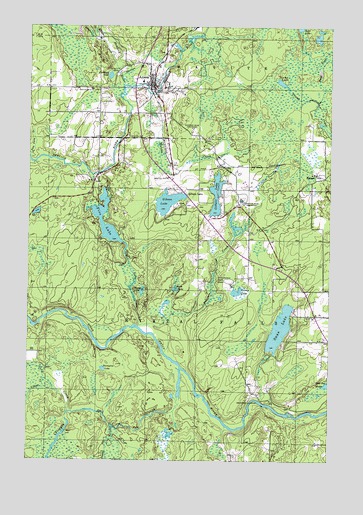
Amasa, MI USGS Topographic Map
Click on map above to begin viewing in our Map Viewer.

This topographic map contains these locations and features:
Feature Name Type Latitude Longitude GNIS ID View Map
AmasaPopulated PlaceN46.2327°W88.4487°620044View Map
Amasa - Hematite Township Volunteer Fire DepartmentBuildingN46.2323°W88.4480°2627065View Map
Amasa Census Designated PlaceCensusN46.2295°W88.4580°2628659View Map
Amasa Community LibraryBuildingN46.2328°W88.4464°2129505View Map
Amasa MuseumBuildingN46.2325°W88.4506°2129500View Map
Amasa Post OfficePost OfficeN46.2328°W88.4503°2129499View Map
Amasa StationLocaleN46.2328°W88.4500°2129501View Map
BalsamPopulated PlaceN46.2077°W88.3810°1617430View Map
Balsam Post Office (historical)Post OfficeN46.2078°W88.3808°2129462View Map
Balsam StationLocaleN46.2078°W88.3792°2129461View Map
Bethany Lutheran ChurchChurchN46.2342°W88.4486°2129504View Map
Camp LakeLakeN46.1736°W88.4138°622596View Map
Casagranda Race TrackLocaleN46.1766°W88.4165°1623273View Map
Cedar CreekStreamN46.1480°W88.4929°622904View Map
Cemetery LakeLakeN46.2357°W88.4669°622969View Map
Chicagon FallsFallsN46.1336°W88.4536°2129514View Map
Chicagon SloughStreamN46.1511°W88.4365°1619488View Map
Dahm LakeLakeN46.1743°W88.4391°624275View Map
East Fork Premo CreekStreamN46.2286°W88.3804°625184View Map
Erickson LandingPopulated PlaceN46.1416°W88.4043°1617547View Map
Fire LakeLakeN46.1909°W88.4686°625982View Map
Fire Lake CreekStreamN46.1638°W88.4537°625984View Map
Gibson LakePopulated PlaceN46.2030°W88.4301°1617581View Map
Gibson LakeLakeN46.1994°W88.4428°626789View Map
Gibson Lake ParkParkN46.1992°W88.4375°2129509View Map
Gilbert LakeLakeN46.2014°W88.4223°626808View Map
Grace United Methodist ChurchChurchN46.2328°W88.4486°2129502View Map
Gravel Pit CreekStreamN46.1341°W88.4646°627247View Map
Harrison CreekStreamN46.2358°W88.4621°627852View Map
Hematite CemeteryCemeteryN46.2366°W88.4632°628073View Map
Little Hemlock RiverStreamN46.2330°W88.4607°630638View Map
Manila CreekStreamN46.2308°W88.4512°631383View Map
Olson CreekStreamN46.1388°W88.4829°634047View Map
Peterson CreekStreamN46.1636°W88.4546°634714View Map
Porcupine LakeLakeN46.1511°W88.4687°635253View Map
Porter MineMineN46.1991°W88.4110°635307View Map
Premo LakeLakeN46.2341°W88.3960°635420View Map
Railroad CreekStreamN46.2458°W88.4354°635594View Map
Shoe Pac LakeLakeN46.1468°W88.3760°637828View Map
Sion Lutheran ChurchChurchN46.2328°W88.4500°2129503View Map
Swamp LakeLakeN46.1738°W88.4529°639142View Map
Swan LakeLakeN46.1631°W88.3955°1614467View Map
Warner MineMineN46.2205°W88.4326°1615776View Map
Youngers CreekStreamN46.2380°W88.4640°1616905View Map

Note: Coordinates in the location and feature list above are referenced to NAD83 datum.


Copyright (C) 2008-2025 Ryan Niemi / Sunset Dynamics ... All Rights Reserved