TopoQuest Logo
Do you find TopoQuest useful?
Help keep TopoQuest running and adding new maps/features by donating!
Bitcoin:  19c7KJd3qBynnjoSw5npx9KScwjBe4ifkT
Litecoin:  LXs6TkuXGGXo1vDsWCkWVdjQX94eUKd6ui
Home View Maps Find Maps Find Places Resources & Links


Galien, Michigan Topographic Map

USGS Map Title: Galien, MI
USGS Map MRC: 41086G4
DRG (GeoTIFF) Download: o41086g4.tif


Neighboring USGS Topographic Map Quads:


  Bridgman, MI  
41086H5
 

  Baroda, MI  
41086H4
 

  Berrien Springs, MI  
41086H3
 

  Three Oaks, MI  
41086G5
 

  Galien, MI  
41086G4
 

  Niles West, MI  
41086G3
 

  New Carlisle, IN  
41086F5
 

  Lydick, IN  
41086F4
 

  South Bend West, IN  
41086F3


Map MRC Location:

N42°
W87°
N42°
W86°
H8 H7 H6 H5 H4 H3 H2 H1
G8 G7 G6 G5 G4 G3 G2 G1
F8 F7 F6 F5 F4 F3 F2 F1
E8 E7 E6 E5 E4 E3 E2 E1
D8 D7 D6 D5 D4 D3 D2 D1
C8 C7 C6 C5 C4 C3 C2 C1
B8 B7 B6 B5 B4 B3 B2 B1
A8 A7 A6 A5 A4 A3 A2 A1
N41°
W87°
N41°
W86°

Galien, MI USGS 1:24K Topographic Map Preview:
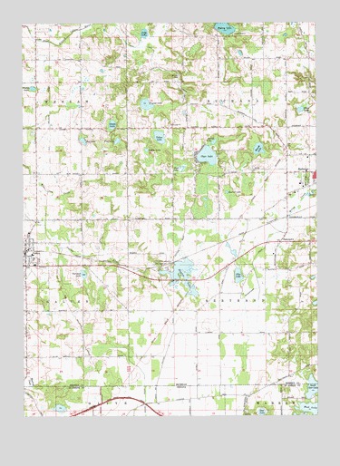
Galien, MI USGS Topographic Map
Click on map above to begin viewing in our Map Viewer.

This topographic map contains these locations and features:
Feature Name Type Latitude Longitude GNIS ID View Map
BakertownPopulated PlaceN41.8050°W86.3908°1618885View Map
Bakertown CemeteryCemeteryN41.8127°W86.3973°2374163View Map
Bakertown DrainCanalN41.7987°W86.4025°1618886View Map
Bertrand Township Fire Department Station 1 HeadquartersBuildingN41.8047°W86.3952°2635934View Map
Burrus LakeLakeN41.8211°W86.4132°1618892View Map
Camp MadronLocaleN41.8709°W86.4100°1618894View Map
Church of the NazareneChurchN41.8275°W86.3753°2377394View Map
Clear LakeLakeN41.8326°W86.4214°1618896View Map
DaytonPopulated PlaceN41.7984°W86.4395°1618897View Map
Dayton CemeteryCemeteryN41.7837°W86.4356°2374135View Map
Dayton LakeLakeN41.7966°W86.4331°1618898View Map
Dayton Post Office (historical)Post OfficeN41.7983°W86.4394°2376494View Map
Dayton StationLocaleN41.7983°W86.4397°2376499View Map
Deer LakeLakeN41.7511°W86.3990°452849View Map
East Clear Lake CampgroundLocaleN41.8350°W86.4194°2377410View Map
GalienPopulated PlaceN41.7981°W86.4992°1618901View Map
Galien High SchoolSchoolN41.8000°W86.4956°2373999View Map
Galien Post OfficePost OfficeN41.8033°W86.4992°2373990View Map
Galien Public LibraryBuildingN41.8056°W86.4992°2373998View Map
Galien StationLocaleN41.8028°W86.4989°2373989View Map
Galien Township CemeteryCemeteryN41.7975°W86.4917°2374169View Map
Galien Township HallBuildingN41.8042°W86.4986°2373995View Map
Galien United Methodist ChurchChurchN41.8047°W86.4992°2373992View Map
Garwood LakeLakeN41.7952°W86.4743°1618902View Map
Hagley LakeLakeN41.8543°W86.4956°1618906View Map
Hancock AirportAirportN41.8524°W86.4352°1623815View Map
Indian LakeLakeN41.8346°W86.4472°1618910View Map
Judy LakeLakeN41.8716°W86.4479°1618913View Map
Madron LakeLakeN41.8735°W86.4137°1618920View Map
McGowan CemeteryCemeteryN41.7864°W86.4211°2374146View Map
Moon LakeLakeN41.8473°W86.3816°1618923View Map
Mud LakeLakeN41.8291°W86.4325°1618925View Map
Mud Lake BogParkN41.8289°W86.4319°2377409View Map
Oak Ridge CemeteryCemeteryN41.8252°W86.3786°1618932View Map
Olive Branch Methodist ChurchChurchN41.7694°W86.4553°2373993View Map
Pike LakeLakeN41.7945°W86.4085°1618935View Map
Pine LakeLakeN41.8374°W86.4596°1618936View Map
Round LakeLakeN41.8371°W86.4185°1618939View Map
Rug LakeLakeN41.8375°W86.4741°1618940View Map
Saint Peters Evangelical ChurchChurchN41.8056°W86.4997°2373994View Map
Shady LakeLakeN41.8427°W86.4617°1618942View Map
South Clear LakeLakeN41.7586°W86.3771°1624942View Map
Stevens Farm CemeteryCemeteryN41.8419°W86.4297°2374142View Map
Township of BuchananCivilN41.8583°W86.4003°1625997View Map
Village of GalienCivilN41.8016°W86.4996°2398938View Map
Village of Galien Police DepartmentBuildingN41.8016°W86.4992°2737616View Map
Wagner LakeLakeN41.8491°W86.4473°1618951View Map
Weaver LakeLakeN41.8348°W86.3995°1618954View Map
Weaver ParkParkN41.8581°W86.4334°1618955View Map
Yellow LakeLakeN41.8387°W86.4416°1618957View Map

Note: Coordinates in the location and feature list above are referenced to NAD83 datum.


Copyright (C) 2008-2025 Ryan Niemi / Sunset Dynamics ... All Rights Reserved