TopoQuest Logo
Do you find TopoQuest useful?
Help keep TopoQuest running and adding new maps/features by donating!
Bitcoin:  19c7KJd3qBynnjoSw5npx9KScwjBe4ifkT
Litecoin:  LXs6TkuXGGXo1vDsWCkWVdjQX94eUKd6ui
Home View Maps Find Maps Find Places Resources & Links


Gallatin, Missouri Topographic Map

USGS Map Title: Gallatin, MO
USGS Map MRC: 39093H8
DRG (GeoTIFF) Download: o39093h8.tif


Neighboring USGS Topographic Map Quads:


  Coffey, MO  
40094A1
 

  Jameson, MO  
40093A8
 

  Bancroft, MO  
40093A7
 

  Altamont, MO  
39094H1
 

  Gallatin, MO  
39093H8
 

  Jamesport, MO  
39093H7
 

  Kidder, MO  
39094G1
 

  Nettleton, MO  
39093G8
 

  Breckenridge, MO  
39093G7


Map MRC Location:

N40°
W94°
N40°
W93°
H8 H7 H6 H5 H4 H3 H2 H1
G8 G7 G6 G5 G4 G3 G2 G1
F8 F7 F6 F5 F4 F3 F2 F1
E8 E7 E6 E5 E4 E3 E2 E1
D8 D7 D6 D5 D4 D3 D2 D1
C8 C7 C6 C5 C4 C3 C2 C1
B8 B7 B6 B5 B4 B3 B2 B1
A8 A7 A6 A5 A4 A3 A2 A1
N39°
W94°
N39°
W93°

Gallatin, MO USGS 1:24K Topographic Map Preview:
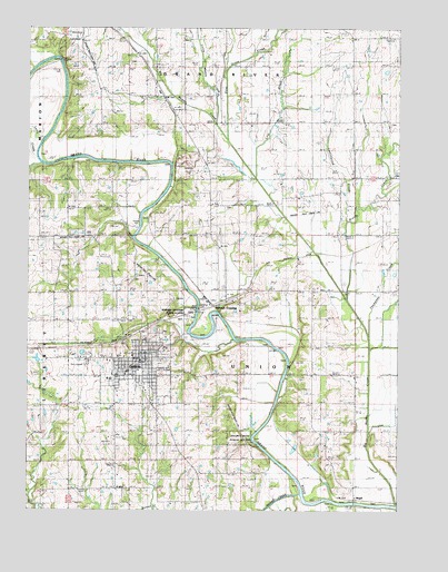
Gallatin, MO USGS Topographic Map
Click on map above to begin viewing in our Map Viewer.

This topographic map contains these locations and features:
Feature Name Type Latitude Longitude GNIS ID View Map
Big Muddy CreekStreamN39.8764°W93.8754°714193View Map
Brushy CreekStreamN39.9295°W93.8926°714902View Map
Calfpen SchoolSchoolN39.9325°W93.9436°730065View Map
Centenary ChurchChurchN39.9170°W93.9044°715625View Map
City of GallatinCivilN39.9106°W93.9642°2394844View Map
Cottonwood CreekStreamN39.9500°W93.8928°716362View Map
Cottonwood School (historical)SchoolN39.8814°W93.9747°716374View Map
Covel D Searcy Elementary SchoolSchoolN39.9102°W93.9715°2545412View Map
Daviess CountyCivilN39.9607°W93.9855°758485View Map
Daviess County Sheriff's OfficeBuildingN39.9150°W93.9620°2752467View Map
Everly CemeteryCemeteryN39.9917°W93.9652°717695View Map
GallatinPopulated PlaceN39.9145°W93.9622°766157View Map
Gallatin Fire Protection DistrictBuildingN39.9157°W93.9648°2621121View Map
Gallatin High SchoolSchoolN39.9087°W93.9721°2545164View Map
Gallatin Police DepartmentBuildingN39.9142°W93.9605°2752514View Map
Gallatin Post OfficePost OfficeN39.9140°W93.9611°2782675View Map
Goodbar SchoolSchoolN39.9756°W93.9005°718561View Map
Greenwood CemeteryCemeteryN39.9241°W93.9656°2681504View Map
Hillcrest CemeteryCemeteryN39.9239°W93.9679°2681505View Map
Holmes Bend Public AccessLocaleN39.8939°W93.9255°742964View Map
Honey CreekStreamN39.8795°W93.9088°719764View Map
Johnson School (historical)SchoolN39.9464°W93.9241°720384View Map
Larry CreekStreamN39.9658°W93.9941°720818View Map
Little Muddy CreekStreamN39.9764°W93.9369°721276View Map
Lost CreekStreamN39.9617°W93.9227°721587View Map
MagillPopulated PlaceN39.8781°W93.8899°741036View Map
Pattonsburg LakeReservoirN39.9667°W93.9947°736181View Map
Pilot Grove CreekStreamN39.9739°W93.9341°724348View Map
Pleasant Grove School (historical)SchoolN39.9486°W93.9824°724508View Map
Splawn Ridge SchoolSchoolN39.9053°W93.9047°726863View Map
Thompson CreekStreamN39.9242°W93.8877°727603View Map
Township of UnionCivilN39.9173°W93.9286°766589View Map
Wabash CrossingPopulated PlaceN39.9283°W93.9380°741342View Map
Wabash Crossing Public AccessLocaleN39.9270°W93.9449°742965View Map

Note: Coordinates in the location and feature list above are referenced to NAD83 datum.


Copyright (C) 2008-2025 Ryan Niemi / Sunset Dynamics ... All Rights Reserved