TopoQuest Logo
Do you find TopoQuest useful?
Help keep TopoQuest running and adding new maps/features by donating!
Bitcoin:  19c7KJd3qBynnjoSw5npx9KScwjBe4ifkT
Litecoin:  LXs6TkuXGGXo1vDsWCkWVdjQX94eUKd6ui
Home View Maps Find Maps Find Places Resources & Links


Jameson, Missouri Topographic Map

USGS Map Title: Jameson, MO
USGS Map MRC: 40093A8
DRG (GeoTIFF) Download: o40093a8.tif


Neighboring USGS Topographic Map Quads:


  Mitchellville, MO  
40094B1
 

  Gilman City West, MO  
40093B8
 

  Gilman City East, MO  
40093B7
 

  Coffey, MO  
40094A1
 

  Jameson, MO  
40093A8
 

  Bancroft, MO  
40093A7
 

  Altamont, MO  
39094H1
 

  Gallatin, MO  
39093H8
 

  Jamesport, MO  
39093H7


Map MRC Location:

N41°
W94°
N41°
W93°
H8 H7 H6 H5 H4 H3 H2 H1
G8 G7 G6 G5 G4 G3 G2 G1
F8 F7 F6 F5 F4 F3 F2 F1
E8 E7 E6 E5 E4 E3 E2 E1
D8 D7 D6 D5 D4 D3 D2 D1
C8 C7 C6 C5 C4 C3 C2 C1
B8 B7 B6 B5 B4 B3 B2 B1
A8 A7 A6 A5 A4 A3 A2 A1
N40°
W94°
N40°
W93°

Jameson, MO USGS 1:24K Topographic Map Preview:
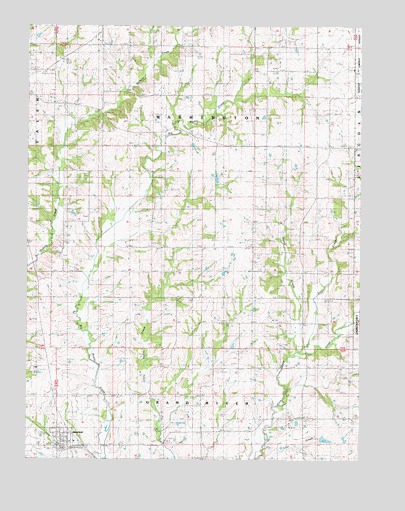
Jameson, MO USGS Topographic Map
Click on map above to begin viewing in our Map Viewer.

This topographic map contains these locations and features:
Feature Name Type Latitude Longitude GNIS ID View Map
Barnett SchoolSchoolN40.0108°W93.9044°713685View Map
Cook LakeReservoirN40.0059°W93.8881°760861View Map
East CreekStreamN40.0303°W93.8974°717269View Map
East DamDamN40.0067°W93.8886°760860View Map
Excelsior School (historical)SchoolN40.0936°W93.9644°717709View Map
Grand River ChurchChurchN40.0120°W93.9574°718675View Map
Hickory Creek Church (historical)ChurchN40.0575°W93.9877°719450View Map
Hill CemeteryCemeteryN40.0900°W93.8763°730117View Map
JamesonPopulated PlaceN40.0053°W93.9794°720251View Map
Jameson Post OfficePost OfficeN40.0052°W93.9876°2782875View Map
Jameson Volunteer Fire Protection DistrictBuildingN40.0044°W93.9868°2620277View Map
Land SchoolSchoolN40.1192°W93.9069°720785View Map
Madelaine (historical)Populated PlaceN40.1189°W93.9111°740192View Map
Mason CreekStreamN40.0306°W93.8986°721952View Map
McCleary SchoolSchoolN40.1189°W93.9655°730145View Map
Netherton School (historical)SchoolN40.0589°W93.9669°723176View Map
North Daviess High SchoolSchoolN40.0052°W93.9822°2545185View Map
Prairie City ChurchChurchN40.0395°W93.9161°724830View Map
Scotland School (historical)SchoolN40.0542°W93.9055°726141View Map
Smith School (historical)SchoolN40.0903°W93.9105°726630View Map
Town of JamesonCivilN40.0059°W93.9878°2397009View Map
Township of Grand RiverCivilN40.0091°W93.9629°766578View Map
Township of WashingtonCivilN40.0901°W93.9343°766590View Map

Note: Coordinates in the location and feature list above are referenced to NAD83 datum.


Copyright (C) 2008-2025 Ryan Niemi / Sunset Dynamics ... All Rights Reserved