TopoQuest Logo
Do you find TopoQuest useful?
Help keep TopoQuest running and adding new maps/features by donating!
Bitcoin:  19c7KJd3qBynnjoSw5npx9KScwjBe4ifkT
Litecoin:  LXs6TkuXGGXo1vDsWCkWVdjQX94eUKd6ui
Home View Maps Find Maps Find Places Resources & Links


Garcon Point, Florida Topographic Map

USGS Map Title: Garcon Point, FL
USGS Map MRC: 30087D1
DRG (GeoTIFF) Download: o30087d1.tif


Neighboring USGS Topographic Map Quads:


  Pace, FL  
30087E2
 

  Milton South, FL  
30087E1
 

  Ward Basin, FL  
30086E8
 

  Pensacola, FL  
30087D2
 

  Garcon Point, FL  
30087D1
 

  Holley, FL  
30086D8
 

  Gulf Breeze, FL  
30087C2
 

  Oriole Beach, FL  
30087C1
 

  South of Holley, FL  
30086C8


Map MRC Location:

N31°
W88°
N31°
W87°
H8 H7 H6 H5 H4 H3 H2 H1
G8 G7 G6 G5 G4 G3 G2 G1
F8 F7 F6 F5 F4 F3 F2 F1
E8 E7 E6 E5 E4 E3 E2 E1
D8 D7 D6 D5 D4 D3 D2 D1
C8 C7 C6 C5 C4 C3 C2 C1
B8 B7 B6 B5 B4 B3 B2 B1
A8 A7 A6 A5 A4 A3 A2 A1
N30°
W88°
N30°
W87°

Garcon Point, FL USGS 1:24K Topographic Map Preview:
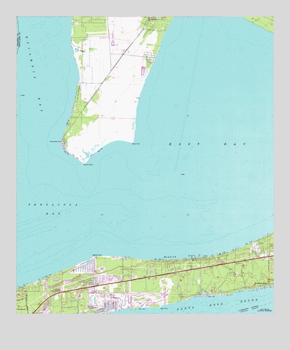
Garcon Point, FL USGS Topographic Map
Click on map above to begin viewing in our Map Viewer.

This topographic map contains these locations and features:
Feature Name Type Latitude Longitude GNIS ID View Map
Avalon Mulat Volunteer Fire Department Substation 12BuildingN30.4688°W87.0915°2644057View Map
Basin BayouStreamN30.4858°W87.0972°278148View Map
Black Hammock CemeteryCemeteryN30.4996°W87.0580°278896View Map
Dickerson CityPopulated PlaceN30.4829°W87.0596°2652393View Map
Dickerson City Census Designated PlaceCensusN30.4826°W87.0651°2629554View Map
East BayBayN30.4701°W87.0104°277636View Map
Garcon FieldAirportN30.4953°W87.0892°309697View Map
Garcon PointCapeN30.4391°W87.0916°282915View Map
Garcon Point Census Designated PlaceCensusN30.4758°W87.0900°2629556View Map
Hernandez PointCapeN30.4474°W87.1019°294333View Map
Memorial Serenity GardensCemeteryN30.3852°W87.1025°286708View Map
Midway Census Designated PlaceCensusN30.4138°W87.0260°2583363View Map
Midway DivisionCivilN30.4037°W87.0288°2648043View Map
Midway Fire District Station 35BuildingN30.3856°W87.0867°2644006View Map
Midway Fire District Station 37BuildingN30.4013°W87.0034°2644343View Map
Redfish CoveBayN30.3997°W87.0463°289567View Map
Redfish PointCapeN30.3991°W87.0852°289577View Map
Saint Pauls ChurchChurchN30.3963°W87.0186°290358View Map
Santa Rosa County Sheriff's Office - District 1 Gulf BreezeBuildingN30.3855°W87.0868°2754483View Map
The Friary of Lakeview CenterHospitalN30.3979°W87.0393°2094906View Map
Tiger PointPopulated PlaceN30.3785°W87.0555°1985711View Map
Tiger Point Census Designated PlaceCensusN30.3775°W87.0579°2629563View Map
WBND-AM (Pensacola Beach)TowerN30.4644°W87.0905°308844View Map
White PointCapeN30.4477°W87.0686°293220View Map
Wilson Memorial ChurchChurchN30.4994°W87.0600°293381View Map
WRNE-AM (Gulf Breeze)TowerN30.4858°W87.0836°308696View Map

Note: Coordinates in the location and feature list above are referenced to NAD83 datum.


Copyright (C) 2008-2024 Ryan Niemi / Sunset Dynamics ... All Rights Reserved