TopoQuest Logo
Do you find TopoQuest useful?
Help keep TopoQuest running and adding new maps/features by donating!
Bitcoin:  19c7KJd3qBynnjoSw5npx9KScwjBe4ifkT
Litecoin:  LXs6TkuXGGXo1vDsWCkWVdjQX94eUKd6ui
Home View Maps Find Maps Find Places Resources & Links


Garden, Michigan Topographic Map

USGS Map Title: Garden, MI
USGS Map MRC: 45086G5
DRG (GeoTIFF) Download: o45086g5.tif


Neighboring USGS Topographic Map Quads:


  Saint Jacques, MI  
45086H6
 

  Garden Corners, MI  
45086H5


  Nahma, MI  
45086G6
 

  Garden, MI  
45086G5


  Fayette, MI  
45086F6
 

  Devils Corner, MI  
45086F5


Map MRC Location:

N46°
W87°
N46°
W86°
H8 H7 H6 H5 H4 H3 H2 H1
G8 G7 G6 G5 G4 G3 G2 G1
F8 F7 F6 F5 F4 F3 F2 F1
E8 E7 E6 E5 E4 E3 E2 E1
D8 D7 D6 D5 D4 D3 D2 D1
C8 C7 C6 C5 C4 C3 C2 C1
B8 B7 B6 B5 B4 B3 B2 B1
A8 A7 A6 A5 A4 A3 A2 A1
N45°
W87°
N45°
W86°

Garden, MI USGS 1:24K Topographic Map Preview:
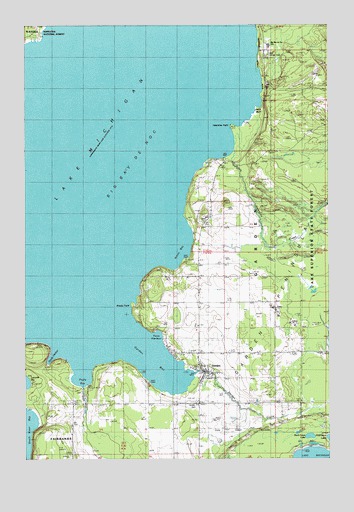
Garden, MI USGS Topographic Map
Click on map above to begin viewing in our Map Viewer.

This topographic map contains these locations and features:
Feature Name Type Latitude Longitude GNIS ID View Map
Ansels PointCapeN45.7944°W86.5793°1619031View Map
Bailey Family CemeteryCemeteryN45.8067°W86.5583°2351949View Map
Biddle House Historical MarkerParkN45.8489°W86.6194°2360368View Map
Big Bay de Noc SchoolSchoolN45.8689°W86.5246°1622370View Map
Buck Fever LakeLakeN45.7564°W86.5081°1619350View Map
Cousineau - Potvin Family CemeteryCemeteryN45.8272°W86.5472°2352326View Map
GardenPopulated PlaceN45.7747°W86.5507°626629View Map
Garden Area Catholic ChurchesChurchN45.7769°W86.5525°2351917View Map
Garden BayBayN45.7769°W86.5682°1619995View Map
Garden Congregational ChurchChurchN45.7775°W86.5536°2351918View Map
Garden CreekStreamN45.7750°W86.5560°626635View Map
Garden Post OfficePost OfficeN45.7667°W86.5533°2351919View Map
Garden Township Volunteer Fire DepartmentBuildingN45.7734°W86.5488°2627068View Map
Garden Township Volunteer Fire DepartmentBuildingN45.7730°W86.5500°2627076View Map
Goully HarborBayN45.7800°W86.6132°1620047View Map
Jacks BluffCliffN45.8530°W86.5254°1620345View Map
Kates BayBayN45.8105°W86.5610°629471View Map
Kates Bay CemeteryCemeteryN45.8066°W86.5440°1620401View Map
New Garden CemeteryCemeteryN45.8669°W86.5249°1621002View Map
Old Garden CemeteryCemeteryN45.7658°W86.5543°1622371View Map
Puffy BayBayN45.7728°W86.6010°635503View Map
Puffy CreekStreamN45.7705°W86.6010°1621322View Map
Tri - Star Emergency Medical Services Station 1BuildingN45.7736°W86.5488°2661929View Map
Tri-Valley Golf CourseLocaleN45.7944°W86.5653°2351914View Map
Valentine CreekStreamN45.8391°W86.5390°1622010View Map
Valentine PointCapeN45.8453°W86.5379°1615443View Map
Vans HarborBayN45.7847°W86.5699°1622018View Map
Vans Harbor Post Office (historical)Post OfficeN45.7839°W86.5675°2351120View Map
Village of GardenCivilN45.7732°W86.5539°2398943View Map

Note: Coordinates in the location and feature list above are referenced to NAD83 datum.


Copyright (C) 2008-2025 Ryan Niemi / Sunset Dynamics ... All Rights Reserved