TopoQuest Logo
Do you find TopoQuest useful?
Help keep TopoQuest running and adding new maps/features by donating!
Bitcoin:  19c7KJd3qBynnjoSw5npx9KScwjBe4ifkT
Litecoin:  LXs6TkuXGGXo1vDsWCkWVdjQX94eUKd6ui
Home View Maps Find Maps Find Places Resources & Links


Garden Corners, Michigan Topographic Map

USGS Map Title: Garden Corners, MI
USGS Map MRC: 45086H5
DRG (GeoTIFF) Download: o45086h5.tif


Neighboring USGS Topographic Map Quads:


  Waco Lake, MI  
46086A6
 

  Gooseneck Lake, MI  
46086A5


  Saint Jacques, MI  
45086H6
 

  Garden Corners, MI  
45086H5


  Nahma, MI  
45086G6
 

  Garden, MI  
45086G5


Map MRC Location:

N46°
W87°
N46°
W86°
H8 H7 H6 H5 H4 H3 H2 H1
G8 G7 G6 G5 G4 G3 G2 G1
F8 F7 F6 F5 F4 F3 F2 F1
E8 E7 E6 E5 E4 E3 E2 E1
D8 D7 D6 D5 D4 D3 D2 D1
C8 C7 C6 C5 C4 C3 C2 C1
B8 B7 B6 B5 B4 B3 B2 B1
A8 A7 A6 A5 A4 A3 A2 A1
N45°
W87°
N45°
W86°

Garden Corners, MI USGS 1:24K Topographic Map Preview:
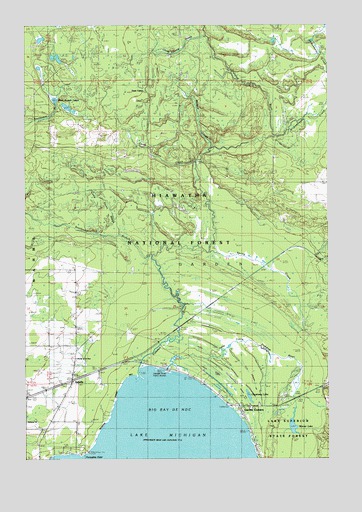
Garden Corners, MI USGS Topographic Map
Click on map above to begin viewing in our Map Viewer.

This topographic map contains these locations and features:
Feature Name Type Latitude Longitude GNIS ID View Map
Archambeau CreekStreamN45.9680°W86.5215°620201View Map
Bethany ChurchChurchN45.8858°W86.6238°1619176View Map
Camp Eleven CreekStreamN45.9966°W86.5496°1619401View Map
Camp Seven CreekStreamN45.9394°W86.5857°622629View Map
Camp Twelve CreekStreamN45.9605°W86.5543°1619415View Map
Cousineau LakeLakeN45.8929°W86.5329°623900View Map
Fish Dam Campground and RV ParkLocaleN45.9014°W86.5622°2351915View Map
Fishdam ParkParkN45.9066°W86.5624°1619917View Map
Fishdam RiverStreamN45.8983°W86.5790°1619918View Map
Garden CornersPopulated PlaceN45.8903°W86.5368°1619997View Map
Garden Corners Rest AreaLocaleN45.8903°W86.5367°2351916View Map
IsabellaPopulated PlaceN45.8975°W86.6057°1617642View Map
Isabella Post Office (historical)Post OfficeN45.8975°W86.6058°2354275View Map
Isabella StationLocaleN45.8972°W86.6056°2354274View Map
Little Fishdam RiverStreamN45.9005°W86.5674°1620550View Map
McIgee CreekStreamN45.9644°W86.5482°1620768View Map
Porcupine PointCapeN45.8769°W86.6013°635255View Map
Saint Ann ChurchChurchN45.9041°W86.6038°1621472View Map
Southwest Branch Fishdam RiverStreamN45.9336°W86.5724°1621712View Map
Spring CreekStreamN45.9347°W86.5485°1621735View Map
Township of GardenCivilN45.9376°W86.5417°1626333View Map
Vans CampLocaleN45.9811°W86.5754°1615514View Map
Warner LakeLakeN45.8846°W86.5148°1622061View Map
West Branch LakesLakeN45.9769°W86.6090°1616046View Map

Note: Coordinates in the location and feature list above are referenced to NAD83 datum.


Copyright (C) 2008-2025 Ryan Niemi / Sunset Dynamics ... All Rights Reserved