TopoQuest Logo
Do you find TopoQuest useful?
Help keep TopoQuest running and adding new maps/features by donating!
Bitcoin:  19c7KJd3qBynnjoSw5npx9KScwjBe4ifkT
Litecoin:  LXs6TkuXGGXo1vDsWCkWVdjQX94eUKd6ui
Home View Maps Find Maps Find Places Resources & Links


Gardiner, Washington Topographic Map

USGS Map Title: Gardiner, WA
USGS Map MRC: 48122A8
DRG (GeoTIFF) Download: o48122a8.tif


Neighboring USGS Topographic Map Quads:


  Dungeness OE E, WA  
48123B1


  Port Townsend North, WA  
48122B7
 

  Sequim, WA  
48123A1
 

  Gardiner, WA  
48122A8
 

  Port Townsend South, WA  
48122A7
 

  Mount Zion, WA  
47123H1
 

  Uncas, WA  
47122H8
 

  Center, WA  
47122H7


Map MRC Location:

N49°
W123°
N49°
W122°
H8 H7 H6 H5 H4 H3 H2 H1
G8 G7 G6 G5 G4 G3 G2 G1
F8 F7 F6 F5 F4 F3 F2 F1
E8 E7 E6 E5 E4 E3 E2 E1
D8 D7 D6 D5 D4 D3 D2 D1
C8 C7 C6 C5 C4 C3 C2 C1
B8 B7 B6 B5 B4 B3 B2 B1
A8 A7 A6 A5 A4 A3 A2 A1
N48°
W123°
N48°
W122°

Gardiner, WA USGS 1:24K Topographic Map Preview:
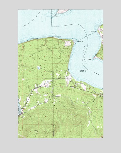
Gardiner, WA USGS Topographic Map
Click on map above to begin viewing in our Map Viewer.

This topographic map contains these locations and features:
Feature Name Type Latitude Longitude GNIS ID View Map
Beckett PointCapeN48.0765°W122.8904°1516356View Map
Blyn Census Designated PlaceCensusN48.0131°W122.9897°2407871View Map
Blyn LookoutLocaleN48.0068°W122.9724°1530097View Map
Cape GeorgeCapeN48.1037°W122.8846°1517376View Map
Cape George Colony Club MarinaLocaleN48.1017°W122.8836°2610336View Map
Cat LakeLakeN48.0681°W122.9711°1517487View Map
Clallam County Fire District 3 Station 35 - Diamond PointBuildingN48.0903°W122.9286°2643476View Map
Diamond PointCapeN48.0940°W122.9146°1518759View Map
Diamond Point AirstripAirportN48.0926°W122.9285°1533778View Map
Eagle CreekStreamN48.0656°W122.9268°1519038View Map
GardinerPopulated PlaceN48.0498°W122.9157°1519892View Map
Gardiner Community ChurchChurchN48.0508°W122.9288°2608605View Map
Gardiner Country ChapelChurchN48.0453°W122.9622°2609845View Map
J and D East PitMineN48.0548°W122.9428°2605755View Map
Jefferson County Fire Protection District 5 Discovery Bay Fire Department Station 52BuildingN48.0491°W122.9093°2643492View Map
Kanem PointCapeN48.1190°W122.9449°1521561View Map
Little Brown Church of BlynChurchN48.0217°W122.9947°2608975View Map
Miller PeninsulaCapeN48.0206°W122.9321°1523187View Map
Protection Island Landing Strip (historical)AirportN48.1245°W122.9291°1534195View Map
Rocky PointCapeN48.0962°W122.9755°1525174View Map
Thompson SpitBarN48.0979°W122.9446°1527114View Map

Note: Coordinates in the location and feature list above are referenced to NAD83 datum.


Copyright (C) 2008-2024 Ryan Niemi / Sunset Dynamics ... All Rights Reserved